


Soil and landforms of south-western Victoria. Part 1. Inventory of soils and their associated landscapes
| Title |
Soil and landforms of south-western Victoria. Part 1. Inventory of soils and their associated landscapes |
| Description |
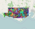
Soils and landforms over 2.4 million hectares were surveyed for their suitability for a change in land use management. To realise the potential for cropping in the higher rainfall regions of south-western Victoria, landform features, critical soil properties, climatic requirements and crop phenology must be considered. This report presents an inventory of the soils and landforms in map format, and of the areal distribution of the different soil-landform units. |
| Author |
Maher, J.M.; Martin, J.J. |
| Keywords | CCMA|Colac|Corangamite|soil|Victoria |
| URL | http://vro.agriculture.vic.gov.au/dpi/vro/coranregn.nsf/pages/soil_landform_mm_soils |
| Abstract |
The higher rainfall regions of the basalt plains of south-western Victoria are seen as having a potential for increased cropping. In order to obtain economic levels of production it is considered important to identify, characterize and map the distribution of the various soils and their associated landforms. Such information will allow planners and researchers to identify likely areas in which to concentrate resources, or to identify areas with limiting soil properties and landform features that may require further investigation. Within the 2.4 million hectares investigated 237 different soils have been recognized using the classification scheme outlined in the report. The distribution of soil and landform combinations is shown in the accompanying maps with a more detailed description of the map units being included in the report. |
| Publish Date | 1st January 1987 |
| Resource Code | 310 |
| ISBN | 730608611 |
| ISSN | 0816-7990 |
| Availability |
IN FILE |
| Related spatial layers |
 SW Victoria soil-landforms (1987)
|