Victorian Resources Online (archived)
Archived content — This page contains material from the Victorian Resources Online (VRO) website. It is no longer maintained and is provided for reference only. This content is hosted by CeRDI and is not endorsed by Agriculture Victoria.
Sitemap
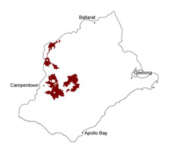
6.1.2 Stony rises of the Volcanic Western Plains
|
The stony rises represent the most recent volcanic activity, the most prominent of which forms the platform from which the Mount Porndon (289 m) scoria cones rise. This feature has been dated as 59 000 years old, placing it among the youngest landforms in Australia (Stone et al. 1977).
The younger stony rises form the most rocky and undulating landscapes, such as the area of Pomborneit East, south of Lake Corangamite. These landscapes are characterised by stony mounds with little or no soil and no surface drainage development. Older stony rise landscapes, such as north of Dreeite, have some soil development and some small ephemeral lakes, swamps and wetlands which have formed in the depressions, but no significant surface drainage systems. Associated soil types are shallow dark gradational and self-mulching (and cracking) clay soils. As the stony rise landscapes develop through geological time, they evolve into plains with poorly developed drainage (geomorphic unit 6.1.3). | |
Soil-landform units
Soil-landform unit | Original unit ID | Unit description | Area (km2) |
| 32 | Lava plain with stony rises (e.g. Derrinallum) | 297 |
| 127 | Undulating stony rises (e.g. Stoneyford) | 171 |
| 131 | Undulating basalt plains (e.g. Dreeite) | 210 |