Victorian Resources Online (archived)
ESAS9
Location: Mingay
Australian Soil Classification: Vertic, Mottled-Mesonatric, Grey SODOSOL
General Landscape Description: Gently undulating plain.
Site Description: Raised bed (2 metre wide) cropping paddock. Gilgai micro relief present.
Geology: Quaternary Basalt.
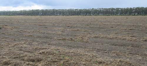 ESAS9 Landscape |
Soil Profile Morphology:
Surface Soil
| A1 | 0-12 cm | Dark greyish brown (10YR4/2); hardsetting and crusting in the surface; fine sandy clay loam; moderate coarse blocky, parting to medium blocky structure; significant amount of buckshot present; pH 5.9: | 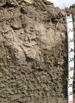 ESAS9 Profile |
| A2 | 12-20/40 cm | Brown (10YR5/3) conspicuously bleached (10YR7/1d); fine sandy clay loam; fine polyhedral structure; pH 5.9; wavy change to: NOTE: depth to subsoil varies due to gilgai. | |
| Subsoil | |||
| B21 | 20/40-50 cm | Dark grey (10YR4/1) with strong brown (7.5YR4/6) mottles; heavy clay; coarse blocky structure; vertic shrink/swell properties; pH 7.1: | |
| B22 | 50-75 cm | Yellowish brown (10YR5/4); heavy clay; lenticular structure; pH 7.8: | |
| B23 | 75-110 cm | Light yellowish brown (2.5Y6/4); heavy clay; coarse lenticular, parting to fine lenticular structure; slickensides evident; pH 8.7. | |
Soil Profile Characteristics:
pH | Salinity Rating | |||
Surface (A1 horizon) | Moderately Acid | Low | Non-Sodic | None |
Subsoil (B21 horizon) | Slightly Alkaline | Low | Strongly Sodic | Strong1 |
Deeper subsoil (at 80-120 cm) | Strongly Alkaline | Medium - High | Strongly Sodic | Strong2 |
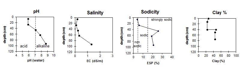
| The surface is moderately acid. The subsoil is slightly alkaline and the deeper subsoil is strongly alkaline. | The salinity rating in the surface is low. The subsoil has a medium to high salinity rating. | The surface is non-sodic. The subsoil is strongly sodic. |
|
Horizon | Horizon Depth (cm) | pH (water) | pH (CaCl2) | EC dS/m | NaCl % | Exchangeable Cations | |||
Ca | Mg | K | Na | ||||||
meq/100g | |||||||||
A1 | 0-12 | 5.9 | 5.4 | 0.17 | 7 | 2.9 | 0.38 | 0.73 | |
A2 | 12-40 | 5.9 | 5.0 | 0.07 | 2.3 | 1.4 | 0.11 | 0.48 | |
B21 | 40-50 | 7.1 | 5.9 | 0.22 | 6 | 8.9 | 0.41 | 5.3 | |
B22 | 50-75 | 7.8 | 6.7 | 0.32 | 0.04 | 6.6 | 10 | 0.32 | 6.7 |
B23 | 75-110 | 8.7 | 8.3 | 1.3 | 0.2 | 7.9 | 14 | 0.37 | 11 |
Horizon | Horizon Depth (cm) | Oxidisable Organic Carbon % | Exchangeable Aluminium mg/kg | Exchangeable Acidity meq/100g | Field Capacity pF2.5 | Wilting Point pF4.2 | Coarse Sand (0.2-2.0 mm) | Fine Sand (0.02-0.2 mm) | Silt (0.002-0.02 mm) | Clay (<0.002 mm) |
A1 | 0-12 | 2.2 | <10 | 7.2 | 24.8 | 11.4 | 17 | 41 | 11 | 26 |
A2 | 12-40 | <10 | 3.9 | 17.5 | 5.9 | 26 | 44 | 6 | 23 | |
B21 | 40-50 | 39.9 | 20.5 | 5 | 33 | 12 | 46 | |||
B22 | 50-75 | 34.5 | 24.9 | 5 | 33 | 16 | 44 | |||
B23 | 75-110 | 46.0 | 24.3 |
Profile Described By: Mark Imhof (March 2008).