Victorian Resources Online (archived)
SFS19a
Location: Teesdale.
Australian Soil Classification: Ferric, Subnatric, Brown SODOSOL
General Landscape Description: Level plain (close to the side of the Leigh River Valley).
Site Description: Southern Farming Systems (SFS) raised bed cropping site.
Geology: Moorabool Viaduct Formation
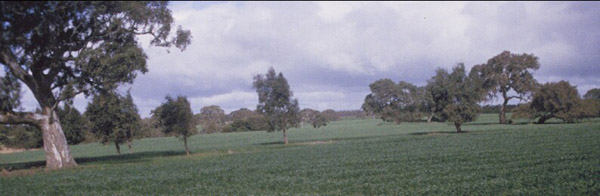 SFS19a Landscape. |
Soil Profile Morphology:
Surface Soil
| A1 | 0-15/18 cm | Sandy; wavy change to: | 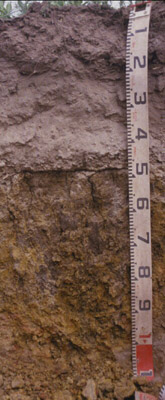 SFS19a Profile. | |
| A2 | 15/18-45 cm | Conspicuously bleached (10YR7/2 dry); abundant medium (5-20 mm) gravel at 35-45 cm depth: | ||
| Subsoil | ||||
| B21 | 45-65+ cm | Brownish yellow (10YR6/8) and red (2.5YR6/8); strong coarse prismatic, parting to strong medium to coarse blocky and strong fine to medium polyhedral and lenticular structure; contains common manganiferous coatings inside peds; pH 7.1. |
Key Profile Features:
- Strong texture contrast between surface (A) horizons and subsoil (B21) horizon.
- Conspicuously bleached subsurface (A2) horizon.
- Prone to wind erosion.
- Prone to water logging.
Soil Profile Characteristics:
pH | Salinity Rating | |||
Subsoil (B21 horizon) | Near Neutral | Low | Sodic | None1 |
Horizon | Horizon Depth (cm) | pH (water) | pH (CaCl2) | EC dS/m | Exchangeable Cations | |||
Ca | Mg | K | Na | |||||
meq/100g | ||||||||
B21 | 45-65 | 7.1 | 6.5 | 0.24 | 4.3 | 12 | 0.53 | 2.2 |
Horizon | Horizon Depth (cm) | Field Capacity pF2.5 | Wilting Point pF4.2 | Coarse Sand (0.2-2.0 mm) | Fine Sand (0.02-0.2 mm) | Silt (0.002-0.02 mm) | Clay (<0.002 mm) |
B21 | 45-65 | 40.1 | 28.1 | 6 | 4 | 4 | 85 |
Profile Described By: Richard MacEwan & Mark Imhof (September 2000).