Victorian Resources Online (archived)
SFS20
Location: Cressy
Australian Soil Classification: Vertic (& Calcic), Mottled-Mesonatric, Black SODOSOL
General Landscape Description: Level plain, potentially a paleo lake bed or high level swamp.
Site Description: Grazing paddock. Southern Farming Systems (SFS) trial site.
Geology: Quaternary - Newer Volcanics.
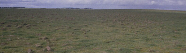 SFS20 Landscape |
Soil Profile Morphology:
| Surface Soil | 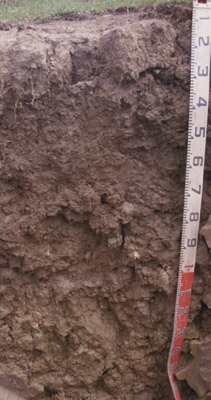 SFS20 Profile | ||
| A1 | 0-5 cm | Dark greyish brown (10YR4/2); fine sandy clay loam; fine crumb structure; pH 5.4; clear boundary to intermittent A2 or B21t horizons: | |
| A2 | 5-30 cm | Intermittent horizon ranging from <0.5 cm to 25 cm thickness; conspicuously bleached light gray (10YR7/1 dry); rusty root channels mottling; clay loam, fine sandy; hard set massive structure (but reflecting cracking pattern of subsoil prisms below); very firm consistence dry; medium (2-5 mm in size) buckshot and well rounded quartz; pH 5.4; abrupt change to: | |
| Subsoil | |||
| B21t | 5/30 - 40 cm | Very dark grey (10YR3/1) with few yellowish brown (10YR5/8) mottles; heavy clay; extremely coarse prismatic structure; very strong consistence dry; extremely dispersive (totally disperses in 5 minutes); pH 7.3; clear change to: | |
| B22 | 40-70 cm | Brown (10YR5/3) with many yellowish brown (10YR5/8) mottles; heavy clay; less definite structure than B21 above or B23 below; sticky consistence at time of sampling; pH 8.6; gradual change to: | |
| B23ss | 70-100 cm | Light yellowish brown (2.5Y6/4); heavy clay; many coarse lenticular peds; slightly calcareous; pH 9.4; gradual change to: | |
| B24k | 100-200 cm | Light olive brown (2.5Y5/4) ; heavy clay; strong coarse lenticular and prismatic structure; fine (1-3 mm in size) buckshot throughout the matrix; very many soft carbonate segregations; pH 9.4; gradual change to: | |
| B25ss | 200+ cm | Greyish brown (2.5Y5/2) with few brownish yellow (10YR6/8) mottles as well as fine black lustrous manganiferous coatings on some ped faces; strongly pedal; frequent very large (up to 1 m in size) slickensides; pH 8.7. | |
Key Profile Features:
- Strong texture contrast between surface (A) horizons and subsoil (B21) horizons.
- Conspicuously bleached surface (A2) horizon.
Soil Profile Characteristics:
pH | Salinity Rating | |||
Surface (A1 horizon) | Strongly Acid | Low | Non-Sodic | None |
Subsoil (B21 horizon) | Slightly Alkaline | Low | Strongly Sodic | Complete |
Deeper subsoil (at 80-110 cm) | Very Strongly Alkaline | Low | Strongly Sodic | Complete |
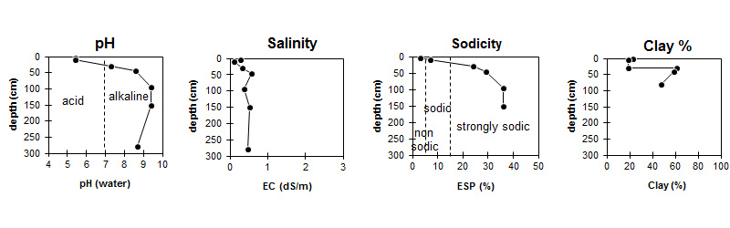
| The pH in the surface is strongly acid. The pH in the upper subsoil is slightly alkaline becoming very strongly alkaline with depth. | The salinity rating is low throughout the profile. | The surface is non sodic. The subsoil is strongly sodic. | The clay content increases abruptly at the surface / subsoil interface. |
Horizon | pH (water) | pH (CaCl2) | EC dS/m | NaCl | Exchangeable Cations | |||
Ca | Mg | K | Na | |||||
meq/100g | ||||||||
A1 | 5.4 | 4.7 | 0.27 | 0.03 | 3.3 | 2.8 | 1.2 | 0.6 |
A2 | 5.4 | 4.5 | 0.12 | 1.6 | 1.8 | 0.27 | 0.88 | |
B21 | 7.3 | 6.5 | 0.33 | 0.03 | 4.4 | 13 | 1.6 | 6.1 |
B22 | 8.6 | 8.0 | 0.56 | 0.05 | 4.3 | 17 | 1.8 | 9.5 |
B23 | 9.4 | 8.5 | 0.37 | 0.06 | 3.3 | 16 | 1.7 | 12 |
B24 | 9.4 | 8.5 | 0.51 | 0.20 | 3.4 | 17 | 1.4 | 12 |
B25 | 8.7 | 7.9 | 0.46 | |||||
Horizon | Exchangeable Aluminium mg/kg | Exchangeable Acidity meq/100g | Oxidisable Organic Carbon % | Total Nitrogen % | Field Capacity pF2.5 | Wilting Point pF4.2 | Coarse Sand (0.2-2.0 mm) | Fine Sand (0.02-0.2 mm) | Silt (0.002-0.02 mm) | Clay (<0.002 mm) |
A1 | 14 | 15 | 5.5 | 0.48 | 37.9 | 15.9 | 11 | 35 | 19 | 23 |
A2 | 37 | 7.6 | 23.2 | 7.3 | 18 | 40 | 19 | 19 | ||
B21 | 44.7 | 26.4 | 6 | 17 | 10 | 62 | ||||
B22 | 47.5 | 28.7 | 6 | 19 | 13 | 59 | ||||
B23 | 47.3 | 26.3 | 8 | 21 | 19 | 48 | ||||
B24 | 46.8 | 26.1 | ||||||||
B25 |
Management Considerations:
- Plant available water capacity (PAWC) is considered to be very low (estimated at 29 mm) in the upper 20 cm of this soil profile. Effective rooting depth (ERD) is restricted to 20 cm due to due to the higly sodic (ESP>20) subsoil.
- Acid topsoil (A1 and A2) and high exchangeable aluminium will limit plant growth in this soil but this can be readily remedied with lime. The subsoil is extremely sodic (ESP = 24-35%) and highly dispersive. This soil is extremely prone to waterlogging. Subsoil conditions are unfavourable for root growth because of the sodic swelling nature of the clay and the extremely coarse structure. Gypsum application will improve subsoil permeability but the coarse structure will remain a limitation. Cropping this soil would not have good prospects without major soil improvement (e.g. use of raised beds, lime and gypsum application, controlled traffic).
Profile Described By: Richard MacEwan & Mark Imhof (September 2000).