Victorian Resources Online (archived)
SFS21
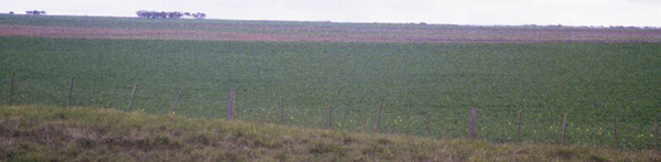
Location: Cressy
Australian Soil Classification: Melanic, Hypercalcic, Black VERTOSOL (or DERMOSOL) (Clayey)
General Landscape Description: Lunette
Site Description: Crest.
Land Use: Pasture prior to forming into raised beds for cropping. Southern Farming Systems (SFS) trial site.
Geology: Quaternary aeolian deposits: sand, clay, calcareous sand
 SFS21 Landscape |
Soil Profile Morphology:
| Surface Soil | 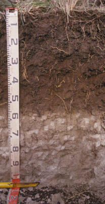 SFS21 Profile | ||
| A11 | 0-10 cm | Black (10YR2/1); self mulching suface condition; light clay; fine crumb structure; pH 6.3; clear change to: | |
| A12 | 10-30 cm | Black (10YR2/1); light clay; rough peds; fine to medium polyhedral structure; strong consistence; pH 6.3; clear change to: | |
| Subsoil | |||
| B21 | 30-60 cm | Very dark grey (7.5YR3/1); light medium clay; moderate coarse polyhedral, parting to strong fine polyhedral structure; pH 7.3; clear change to: | |
| B22k | 60-130+ cm | Light brownish grey (2.5Y6/2); light medium clay; apedal; very common fine pores; some larger root channels infilled with A and B horizon material; highly calcareous; pH 8.5. | |
Key Profile Features:
- Well structured soil profile.
- Very calcareous in deeper subsoil.
Soil Profile Characteristics:
pH | Salinity Rating | |||
Surface (A1 horizon) | Slightly Acid | Low | Non-Sodic | None |
Subsoil (B21 horizon) | Slightly Alkaline | Very Low | Non-Sodic | None1 |
Deeper Subsoil (at 75-85 cm) | Moderately Alkaline | Low | Non-Sodic | None |
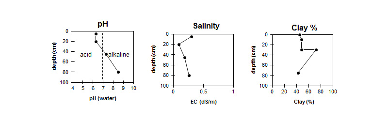
| The pH in the surface is slightly acid. The pH in the subsoil is slightly alkaline, becoming moderately alkaline with depth. | The salinity rating is low to very low throughout the profile. | The clay content increases sharply at the surface / subsoil interface. |
Horizon | Horizon Depth (cm) | pH (water) | pH (CaCl2) | EC dS/m | NaCl | Exchangeable Cations | |||
Ca | Mg | K | Na | ||||||
meq/100g | |||||||||
A1 | 0-10 | 6.3 | 5.9 | 0.30 | 0.04 | 11.0 | 5.5 | 2.3 | 0.3 |
A12 | 10-30 | 6.3 | 5.7 | 0.09 | 12.0 | 8.0 | 2.6 | 0.27 | |
B21 | 30-60 | 7.3 | 6.8 | 0.19 | 18.0 | 16.0 | 2.6 | 0.41 | |
B22k | 60-130+ | 8.5 | 8.0 | 0.26 | 24.0 | 15.0 | 1.4 | 0.48 | |
Horizon | Horizon Depth (cm) | Exchangeable Aluminium mg/kg | Exchangeable Acidity meq/100g | Oxidisable Organic Carbon % | Total Nitrogen % | Field Capacity pF2.5 | Wilting Point pF4.2 | Coarse Sand (0.2-2.0 mm) | Fine Sand (0.02-0.2 mm) | Silt (0.002-0.02 mm) | Clay (<0.002 mm) |
A1 | 0-10 | 11 | 4.2 | 0.4 | 36.3 | 20.9 | 12 | 19 | 16 | 45 | |
A12 | 10-30 | <10 | 8.7 | 33.2 | 20.6 | 16 | 17 | 13 | 48 | ||
B21 | 30-60 | 48.6 | 31.4 | 5 | 8 | 7 | 72 | ||||
B22k | 60-130+ | 39.3 | 25.2 | 3 | 7 | 9 | 43 |
Management Considerations:
- The lunette soils in the Victorian Volcanic Plain may have sandy or clay profiles, with clay profiles, as in this case (SFS21), being generally more common. Occurrence is very localised and of limited spatial extent. The soils are well structured and have high fertility. Site drainage is usually good but because the clay content is high and the clays swell, internal drainage is often poor and the soil surface becomes sticky and difficult to manage when wet.
Whole Profile
- Plant available water capacity (PAWC) is considered to be medium (estimated at 125 mm) in the upper 100 cm of this soil profile.
Profile Described By: Richard MacEwan & Mark Imhof (September 2000).