Victorian Resources Online (archived)
SW33
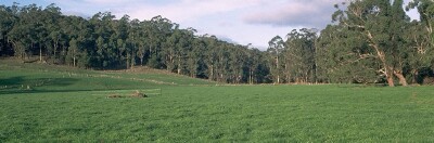
Location: Kawarren
Australian Soil Classification: Acidic, Dermosolic, Redoxic HYDROSOL
Map Unit: Map Unit 147 (Maher and Martin, 1987).
General Landscape Description: Level plain.
Site Description: Grazing paddock (dairy).
Geology: Quaternary sediments overlying Tertiary - Dilwyn Formation.
 SW33 Landscape |
Soil Profile Morphology:
Surface Soil
| A1 | 0-20 cm | Greyish brown (10YR3/2); rusty root channel mottling present; very fine sandy clay loam; weak coarse blocky, parting to moderate medium blocky structure; weak consistence moist; pH 5.1: | 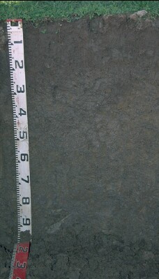 SW33 Profile |
| Subsoil | |||
| B21 | 20-45 cm | Brown (10YR5/3) with yellowish brown (10YR5/8) mottles; light clay; moderate medium polyhedral structure; weak consistence moist; pH 4.9: | |
| B22 | 45-100 cm | Grey (10YR5/1) with yellowish brown (10YR5/6) mottles; medium clay; strong medium polyhedral, parting to strong fine polyhedral structure; weak consistence moist; pH 4.7. |
Key Profile Features:
- The soil profile will be saturated for a number of months in most years.
Soil Profile Characteristics:
pH | Salinity Rating | |||
Surface (A1 horizon) | Strongly Acid | Low | Non-Sodic | None |
Subsoil (B21 horizon) | Very Strongly Acid | Low | Non-Sodic | None |
Deeper subsoil (at 1 m) | Very Strongly Acid | Very Low | Non-Sodic | None |
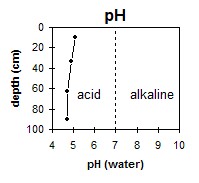 The surface horizon is strongly acid. The subsoil is very strongly acid. | 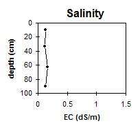 The whole profile has a low to very low salinity rating. | 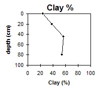 The clay content gradually increases with depth. |
Horizon | Horizon Depth (cm) | pH (water) | pH (CaCl2) | EC (dS/m) | Exchangeable Cations | |||
Ca | Mg | K | Na | |||||
meq/100g | ||||||||
A1 | 0-20 | 5.1 | 4.4 | 0.13 | 3.9 | 0.9 | 0.2 | 0.05 |
B21 | 20-45 | 4.9 | 4.2 | 0.12 | 2.5 | 1.6 | 0.2 | 0.05 |
B22 | 45-80 | 4.7 | 4 | 0.16 | 1.6 | 3.3 | 0.3 | 0.2 |
B23 | 80-100 | 4.7 | 3.9 | 0.13 | 1.2 | 3.7 | 0.2 | 0.2 |
Horizon | Horizon Depth (cm) | Acidity meq/100g | Oxidisable Organic Carbon % | Total Nitrogen % | Field Capacity pF2.5 | Wilting Point pF4.2 | Coarse Sand (0.2- 2.0 mm) | Fine Sand (0.02- 0.2 mm) | Silt (0.002- 0.02 mm) | Clay (<0.002 mm) |
A1 | 0-20 | 3.2 | 0.23 | 28.7 | 11.2 | 9 | 50 | 14 | 24 | |
B21 | 20-45 | 12 | 29.2 | 13.6 | 10 | 41 | 10 | 38 | ||
B22 | 45-80 | 38.8 | 21.2 | 7 | 26 | 7 | 57 | |||
B23 | 80-100 | 8 | 27 | 8 | 54 |
Profile Described By: Mark Imhof and Austin Brown (June, 1998).