Victorian Resources Online (archived)
SW40
Location: Barongarook West.
Australian Soil Classification: Humose-Acidic, Mesotrophic, Grey DERMOSOL (very thick loamy surface).
Map Unit: Map Unit 157 (Maher and Martin, 1987).
General Landscape Description: Gently undulating rise.
Site Description: Grazing paddock (dairy).
Geology: Tertiary - Dilwyn Formation.
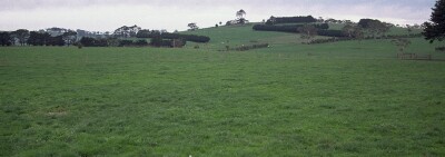 SW40 Landscape |
Soil Profile Morphology:
Surface Soil
| A11 | 0-25 cm | Black (10YR2/1); light fine sandy clay loam; weak to moderate coarse blocky structure; weak consistence moist; pH 5.4: | 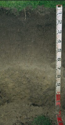 SW40 Profile |
| A12 | 25-40 cm | Very dark brown (10YR2/2); fine sandy clay loam; weak coarse blocky structure; weak consistence moist; pH 5.5: | |
| A21 | 40-60 cm | Brown (10YR5/3); fine sandy clay loam; weakly structured; weak consistence moist; pH 5.3: | |
| A22 | 60-75 cm | Pale brown (10YR6/3); fine sandy loam; weakly structured; firm consistence moist; pH 5.1: | |
| Subsoil | |||
| B21 | 75-90 cm | Pale brown (10YR6/3) with brownish yellow (10YR6/6) mottles; fine sandy clay; weak to moderate medium blocky structure; firm consistence moist; pH 5.1: | |
| B22 | 90+ cm | Grey (10YR5/1) with yellowish brown (10YR5/8) mottles; fine sandy clay; strong coarse blocky, parting to moderate to strong medium blocky structure; shiny faced peds; firm consistence moist; contains very few (2%) quartz fragments (2-5 mm in size); pH 5.0. |
Soil Profile Characteristics:
pH | Salinity Rating | |||
Surface (A11 horizon) | Strongly Acid | Moderate | Non-Sodic | None |
Subsoil (B21 horizon) | Strongly Acid | Low-Moderate | Non-Sodic | None |
Deeper Subsoil (at 90+ cm) | Strongly Acid | Low-Moderate | Non-Sodic | None |
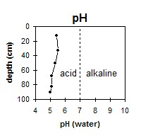 The whole profile is strongly acid throughout. | 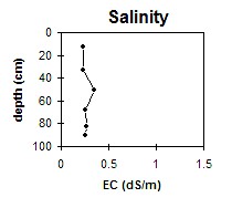 The profile has a low to moderate salinity rating throughout. | 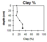 The clay content increases gradually with depth. |
Horizon | Horizon Depth (cm) | pH (water) | pH (CaCl2) | EC (dS/m) | NaCl % | Exchangeable Cations | |||
Ca | Mg | K | Na | ||||||
meq/100g | |||||||||
A11 | 0-25 | 5.4 | 4.7 | 0.23 | 0.03 | 3.8 | 1.2 | 0.2 | 0.3 |
A12 | 25-40 | 5.5 | 4.8 | 0.23 | 0.04 | 1.4 | 0.9 | 0.1 | 0.1 |
A21 | 40-60 | 5.3 | 4.7 | 0.35 | 0.07 | 0.6 | 0.6 | 0.05 | 0.05 |
A22 | 60-75 | 5.1 | 4.6 | 0.26 | 0.06 | 0.5 | 1.9 | <0.1 | 0.2 |
B21 | 75-90 | 5.1 | 4.5 | 0.27 | 0.07 | 0.9 | 0.6 | <0.1 | 0.05 |
B22 | 90+ | 5 | 4.4 | 0.26 | 0.06 | 0.3 | 2.9 | <0.1 | 0.4 |
Horizon | Horizon Depth (cm) | Field Capacity pF2.5 | Wilting Point pF4.2 | Acidity meq/100g | Oxidisable Organic Carbon % | Coarse Sand (0.2- 2.0 mm) | Fine Sand (0.02- 0.2 mm) | Silt (0.002- 0.02 mm) | Clay (<0.002 mm) |
A11 | 0-25 | 26.4 | 10.7 | 4.8 | 26 | 38 | 17 | 12 | |
A12 | 25-40 | 17.4 | 5.3 | 28 | 40 | 18 | 13 | ||
A21 | 40-60 | 16 | 3.1 | 29 | 43 | 20 | 10 | ||
A22 | 60-75 | 20.5 | 7.3 | 25 | 38 | 15 | 21 | ||
B21 | 75-90 | 25.2 | 11.2 | 6.5 | 22 | 33 | 15 | 31 | |
B22 | 90+ | 25.7 | 11 | 6.7 | 21 | 34 | 12 | 31 |
Profile Described By: Mark Imhof and Austin Brown (June 1998).