Victorian Resources Online (archived)
SW42
Location: Cobden
Australian Soil Classification: Melacic-Mottled (& Vertic), Eutrophic, Brown CHROMOSOL (thick clay loamy surface).
Map Unit: Map Unit 20 (Maher and Martin, 1987).
General Landscape Description: Upper slope of gently undulating rise.
Site Description: Grazing paddock (dairy).
Geology: Tertiary - Gellibrand Marl
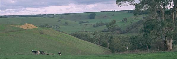 SW42 Landscape |
Soil Profile Morphology:
Surface Soil
| A1 | 0-30 cm | Very dark greyish brown (10YR3/2); clay loam (very fine sandy); moderate coarse blocky, parting to moderate medium polyhedral and moderate fine polyhedral structure; weak consistence moist; pH 5.3: | 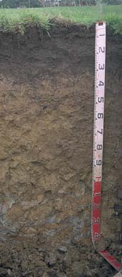 SW42 profile |
| A2 | 30-35 cm | Brown (10YR5/3); clay loam; discontinuous and clear change to: | |
| Subsoil | |||
| B21 | 35-60 cm | Yellowish brown (10YR5/4) with many (30%) brownish yellow (10YR6/6) mottles; medium clay; strong medium blocky, parting to strong fine blocky and lenticular structure; some slickensides present; contains few (5%) very coarse (2-5cm) iron nodules in patches; weak consistence moist; pH 6.5: | |
| B22 | 60-80 cm | Light olive brown (2.5Y5/4) with many brownish yellow (10YR6/6) mottles; medium clay; lenticular structure; weak consistence moist; pH 6.8: | |
| B23 | 80-110 cm | Light olive brown (2.5Y5/4) with many brownish yellow (10YR6/6) mottles; medium clay; moderate very coarse prismatic, parting to moderate coarse blocky structure; large slickensides present; very firm consistence moist; pH 6.9: | |
| B3 | 110+ cm | Grey (N5) with brownish yellow (10YR6/8) and some red mottles; medium clay; large slickensides present; very firm consistence moist; pH 6.8. | |
Key Profile Features:
- Strong texture contrast between surface (A) horizon and subsoil (B21) horizon.
Soil Profile Characteristics:
pH | Salinity Rating | |||
Surface (A1 horizon) | Strongly Acid | Low | Non-Sodic | None |
Subsoil (B21 horizon) | Slightly Acid | Very Low | Non-Sodic | None |
Deeper Subsoil (at 1 m) | Slightly Acid | Low | Sodic | Slight1 |
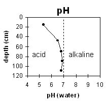 |  |
The surface horizon is strongly acid. The subsoil is slightly acid. | The salinity rating is low throughout the profile. |
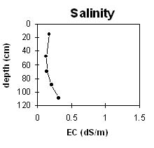
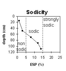 | 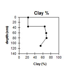 |
The surface and upper subsoil is non-sodic. The subsoil becomes sodic at about 60 cm depth. | The clay content increases markedly at 35 cm depth. |
Horizon | Horizon Depth (cm) | pH (water) | pH CaCl2 | EC (dS/m) | NaCl % | Exchangeable Cations | |||
Ca | Mg | K | Na | ||||||
meq/100g | |||||||||
A1 | 0-30 | 5.3 | 4.7 | 0.17 | 7.4 | 1.5 | 0.4 | 0.05 | |
A2 | 30-35 | ||||||||
B21 | 35-60 | 6.5 | 5.7 | 0.13 | 9.5 | 6.2 | 0.2 | 0.7 | |
B22 | 60-80 | 6.8 | 6 | 0.14 | 8.8 | 7 | 0.2 | 1.4 | |
B23 | 80-110 | 6.9 | 6.2 | 0.21 | 10 | 7.8 | 0.1 | 2.4 | |
B3 | 110+ | 6.8 | 6 | 0.31 | 0.04 | 9 | 7.1 | 0.1 | 2.7 |
Horizon | Horizon Depth (cm) | Acidity meq/100g | Oxidisable Organic Carbon % | Total Nitrogen % | Field Capacity pF2.5 | Wilting Point pF4.2 | Coarse Sand (0.2-2.0 mm) | Fine Sand (0.02-0.2 mm) | Silt (0.002-0.02 mm) | Clay (<0.002 mm) |
A1 | 0-30 | 4.0 | 0.29 | 37.6 | 17.2 | 8 | 34 | 16 | 22 | |
A2 | 30-35 | |||||||||
B21 | 35-60 | 10 | 51.8 | 29.2 | 6 | 16 | 7 | 64 | ||
B22 | 60-80 | 53.9 | 30 | 4 | 14 | 6 | 68 | |||
B23 | 80-110 | 57.8 | 30.5 | 3 | 14 | 7 | 69 | |||
B3 | 110+ | 48.4 | 26.6 | 17 | 16 | 8 | 54 |
Profile Described By: Mark Imhof and Austin Brown (June 1998).