Victorian Resources Online (archived)
SW51
Location: Cooriemungle.
Australian Soil Classification: Bleached-Acidic, Dystrophic, Grey DERMOSOL.
Map Unit: Unmapped.
General Landscape Description: Lower slope of Gently Undulating Rises.
Site Description: Grazing paddock (dairy).
Geology: Tertiary – Moorabool Viaduct Formation.
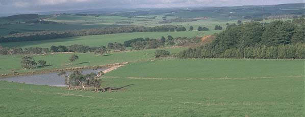 SW51 Landscape |
Soil Profile Morphology:
Surface Soil
| A1 | 0-15 cm | Black (10YR2/1); fine sandy clay loam; weakly structured; weak consistence moist; contains very few (2%) quartz nodules (2-5 mm in size); pH 5.3; clear change to: |
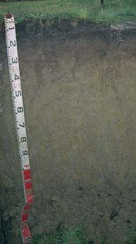 SW51 Profile |
| A2 | 15-25 cm | Pale brown (10YR6/3), conspicuously bleached; very finesandy clay loam; weakly structured; weak consistence moist; contains very few (2%) quartz nodules (2-5 mm in size); pH 5.2; clear change to: | |
| Subsoil | |||
| B21 | 25-60 cm | Pale brown (10YR6/3) with many brownish yellow (10YR6/6) and yellowish brown (10YR5/8) mottles; light clay very fine sandy; moderate coarse blocky, parting to strong medium blocky structure; weak consistence moist; pH 5.5; gradual change to: | |
| B22 | 60-80 cm | Light brownish grey (10YR6/2) with many yellowish brown (10YR5/8) mottles; light mediumclay; strong medium blocky structure; weak consistence moist; pH 5.1; gradual change to: | |
| B23 | 80-110 cm | Grey (10YR6/1) with many yellowish brown (10YR5/8) mottles; light medium clay; strong coarse blocky, parting to moderate fine polyhedral structure; shiny peds; firm consistence moist; pH 5.3. | |
Key Profile Features:
- Strongly acid throughout the profile.
Soil Profile Characteristics:
pH | Salinity Rating | |||
Surface (A1 horizon) | Strongly Acid | Very Low | Non-Sodic | None |
Subsoil (B21 horizon) | Strongly Acid | Very Low | Non-Sodic | Slight1 |
Deeper Subsoil (at 1 m) | Strongly Acid | Very Low | Non-Sodic | None |
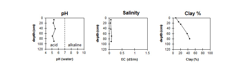
This profile is strongly acid throughout. | This profile has a very low salinity rating throughout. | The clay content increases gradually with depth. |
Horizon | Horizon Depth (cm) | pH (water) | pH CaCl2 | EC 1:5 | Exchangeable Cations | |||
Ca | Mg | K | Na | |||||
meq/100g | ||||||||
A1 | 0-15 | 5.3 | 4.4 | 0.07 | 6.1 | 1 | 0.1 | 0.05 |
A2 | 15-25 | 5.2 | 4.1 | 0.06 | 1.6 | 0.5 | <0.1 | 0.2 |
B21 | 25-60 | 5.5 | 4.2 | 0.07 | 1 | 0.6 | <0.1 | 0.4 |
B22 | 60-80 | 5.1 | 4.1 | 0.09 | 0.9 | 1.6 | 0.1 | 0.4 |
B23 | 80-110 | 5.3 | 4.2 | 0.08 | 0.7 | 2.8 | <0.1 | 0.4 |
Horizon | Horizon Depth (cm) | Acidity meq/100g | Oxidisable Organic Carbon % | Total Nitrogen % | Field Capacity pF2.5 | Wilting Point pF4.2 | Coarse Sand (0.2-2.0 mm) | Fine Sand (0.02-0.2 mm) | Silt (0.002-0.02 mm) | Clay (<0.002 mm) |
A1 | 0-15 | 4.9 | 0.38 | 29 | 11 | 10 | 51 | 21 | 8 | |
A2 | 15-25 | 21 | 7 | 8 | 53 | 22 | 15 | |||
B21 | 25-60 | 9.5 | 24 | 9 | 7 | 50 | 22 | 21 | ||
B22 | 60-80 | 30 | 14 | 7 | 40 | 17 | 38 | |||
B23 | 80-110 | 34 | 18 | 6 | 35 | 16 | 45 |
Profile Described By: Mark Imhof and Austin Brown (August 1998).