Victorian Resources Online (archived)
SW52
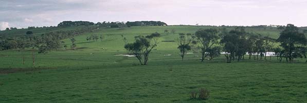
Location: Cowleys Creek
Australian Soil Classification: Vertic (& Bleached-Acidic), Eutrophic, Grey DERMOSOL
Map Unit: Unit 158 (Maher and Martin, 1987).
General Landscape Description: Gently undulating rises.
Site Description: Grazing paddock (dairy).
Geology: Tertiary - Gellibrand Marl.
 SW52 Landscape |
Soil Profile Morphology:
Surface Soil
| A1 | 0-12 cm | Very dark greyish brown (10YR3/2); very fine sandy clay loam; weak to moderate medium blocky structure; pH 5.3; clear change to: | 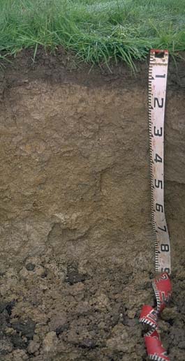 SW52 Profile |
| A2 | 12-20 cm | Pale brown (10YR6/3), conspicuously bleached; rusty root channel mottling; very fine sandy clay loam; moderate medium blocky structure; pH 4.9; gradual change to: | |
| Subsoil | |||
| B21 | 20-35 cm | Pale brown (10YR6/3) with a few yellowish brown (10YR5/8) mottles; light clay; moderate coarse blocky, parting to strong medium blocky structure; pH 4.9; gradual change to: | |
| B22 | 35-65 cm | Brown (10YR5/3) with many yellowish brown (10YR5/8) mottles; medium clay; moderate coarse prismatic, parting to strong medium polyhedral structure; pH 4.9; gradual change to: | |
| B23 | 65+ cm | Grey (10YR6/1) with many yellowish brown (10YR5/8) mottles; medium clay; strong coarse polyhedral, parting to strong fine polyhedral structure; many slickensides evident; pH 5.2. | |
| Deeper Subsoil | Yellowish brown (10YR5/8); clay; contains calcareous segregations. | ||
Key Profile Features:
- Strongly acid profile.
Soil Profile Characteristics:
pH | Salinity Rating | |||
Surface (A1 horizon) | Strongly Acid | Low-Moderate | Non-Sodic | None |
Subsoil (B21 horizon) | Very Strongly Acid | Low | Non-Sodic | None1 |
Deeper Subsoil (at 65+ cm) | Strongly Acid | Low | Non-Sodic | Slight2 |
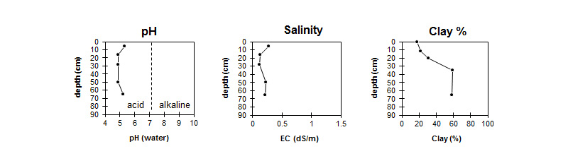
The profile is strongly to very strongly acid throughout. | This profile has a mainly low salinity rating throughout. | The clay content increases gradually with depth. |
Horizon | Horizon Depth (cm) | pH (water) | pH CaCl2 | EC 1:5 | NaCl % | Exchangeable Cations | |||
Ca | Mg | K | Na | ||||||
meq/100g | |||||||||
A1 | 0-12 | 5.3 | 4.6 | 0.27 | 0.01 | 5.3 | 2.2 | 1 | 0.1 |
A2 | 12-20 | 4.9 | 4.2 | 0.13 | 2.6 | 1.5 | 0.4 | 0.05 | |
B21 | 20-35 | 4.9 | 4.1 | 0.12 | 2.8 | 2.4 | 0.3 | 0.2 | |
B22 | 35-65 | 4.9 | 4.2 | 0.23 | 6.7 | 5.8 | 0.4 | 0.4 | |
B23 | 65+ | 5.2 | 4.4 | 0.21 | 7.9 | 8.8 | 0.2 | 1.3 | |
Horizon | Horizon Depth (cm) | Field Capacity pF2.5 | Wilting Point pF4.2 | Acidity meq/100g | Oxidisable Organic Carbon % | Total Nitrogen % | Coarse Sand (0.2-2.0 mm) | Fine Sand (0.02-0.2 mm) | Silt (0.002-0.02 mm) | Clay (<0.002 mm) |
A1 | 0-12 | 43 | 16.5 | 5.3 | 0.5 | 3 | 35 | 31 | 18 | |
A2 | 12-20 | 30.8 | 10 | 1 | 40 | 35 | 22 | |||
B21 | 20-35 | 30.2 | 13.6 | 9.1 | 1 | 34 | 34 | 31 | ||
B22 | 35-65 | 41.3 | 23 | 1 | 19 | 18 | 59 | |||
B23 | 65+ | 45.2 | 23.2 | 1 | 15 | 21 | 58 |
Profile Described By: Mark Imhof and Austin Brown (August 1998).