Victorian Resources Online (archived)
SW53
Location: Cooriemungle.
Australian Soil Classification: Vertic (& Sodic), Calcic, Grey CHROMOSOL
Geology: Gellibrand Marl.
Land Use: Dairy cattle grazing.
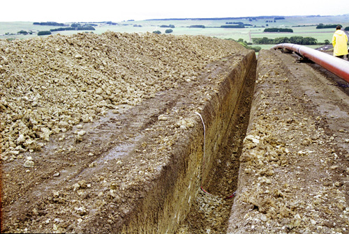 SW53 Landscape. |
Soil Profile Morphology:
Surface Soil
| A1 | 0-15 cm | Very dark greyish brown (10YR3/2); silty clay loam; weakly pedal; fine to medium polyhedral structure; pH 5.7; abrupt and smooth change to: | 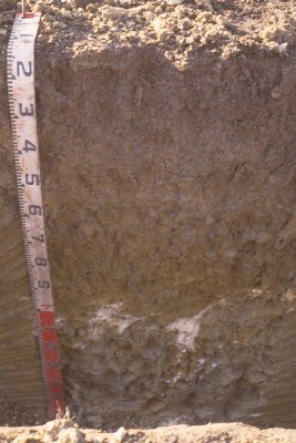 SW53 profile. Note: Surface (A) horizon has been stripped from the soil profile. |
| Subsoil | |||
| B21g | 15-60/70 cm | Dark greyish brown (2.5Y4/2) with common yellowish brown (10YR5/8) mottles; medium clay; coarse polyhedral, parting to fine to medium polyhedral structure; pH 5.7; gradual and wavy change to: | |
| B22g | 60/70-105/115 cm | Light olive brown (2.5Y5/4) and grey (2.5Y5/1); medium to heavy clay; coarse polyhedral or angular blocky, parting to fine to medium polyhedral structure; slickensides (>20 mm in size); pH 7.4; abrupt and irregular change to: | |
| B23kgss | 105/115-160+ cm | Light olive grey (5Y6/2) with common yellowish brown (10YR5/8) mottles; heavy clay; very coarse angular blocky, parting to coarse polyhedral or angular blocky, and fine to mediumlenticular structure; soft white extremely coarse (100 mm in size) calcareous accumulations at top of horizon; slickensides (>100 mm); pH 8.9. | |
Key Profile Features:
- Strong texture contrast between surface (A) horizon and subsoil (B21) horizon.
- Vertic properties (slickensides present) in deeper subsoil.
Soil Profile Characteristics:
pH | Salinity Rating | |||
Surface (A1 horizon) | Moderately Acid | Low | Non-Sodic | None |
Subsoil (B21 horizon) | Moderately Acid | Low | Non-Sodic | None |
Deeper Subsoil (at 70- 105 cm) | Slightly Alkaline | Low | Sodic | Strong1 |
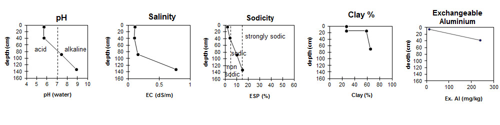
| The surface and upper subsoil is moderately acid. The subsoil at 1 metre is slightly alkaline becoming strongly alkaline at depth. | Salinity rating is low down to 1 metre and increases to medium at depth. | The surface and upper subsoil is non-sodic becoming sodic in the deeper subsoil. | Clay content increases markedly at the surface / subsoil boundary. | Exchangeable Aluminium increases to very high levels in the subsoil. |
Horizon | Horizon Depth (cm) | pH (water) | pH (CaCl2) | EC (dS/m) | NaCl % | Exchangeable Cations | |||
Ca | Mg | K | Na | ||||||
meq/100g | |||||||||
A1 | 0-15 | 5.7 | 4.9 | 0.11 | 8.8 | 3.8 | 0.63 | 0.48 | |
B21 | 15-60/70 | 5.7 | 4.5 | 0.1 | 8.5 | 9.4 | 0.51 | 1.2 | |
B22 | 60/70-105/115 | 7.4 | 6.2 | 0.16 | 16 | 13 | 0.43 | 3.2 | |
B23 | 105/115-160 | 8.9 | 8.9 | 0.77 | 0.09 | 16 | 14 | 2.9 | 5.8 |
Horizon | Horizon Depth (cm) | Oxidisable Organic Carbon % | Total Nitrogen % | Exchangeable Aluminium mg/kg | Exchangeable Acidity meq/100g | Field Capacity pF2.5 | Wilting Point pF4.2 | Coarse Sand (0.2-2.0 mm) | Fine Sand (0.02-0.2 mm) | Silt (0.002-0.02 mm) | Clay (<0.002 mm) |
A1 | 0-15 | 4.2 | 0.3 | 13 | 15 | 39 | 17 | 7 | 25 | 30 | 27 |
B21 | 15-60/70 | 240 | 13 | 45 | 24 | 1 | 17 | 19 | 59 | ||
B22 | 60/70-105/115 | 53 | 26 | 1 | 12 | 18 | 65 | ||||
B23 | 105/115-160 |
Management Considerations:
Surface (A) Horizon
- In its natural state the surface soil is well structured and strongly pedal. The description here "weakly pedal" is a reflection of the damaged caused by pugging, a common winter effect in the Heytsbury district.
- The level of exchangeable aluminium measured in this horizon is high. This may restrict the growth of aluminium sensitive species.
Profile Described By: Mark Imhof and Richard MacEwan (March 1999).