Victorian Resources Online (archived)
SW8
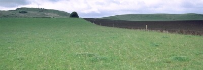
Location: Alvie
Australian Soil Classification: Sodic, Eutrophic, Brown DERMOSOL
General Landscape Description: Lower slope of a gently undulating rise.
Geology: Quaternary volcanic ash deposits (Qvs).
Land Use: Pasture has been cultivated and improved. Alternate with silage crop. Irrigated in Summer.
SW8 Landscape
Soil Profile Morphology:
Surface Soil
| A1 | 0-15 cm | Brown (7.5YR4/2); firm surface condition; fine sandy clay loam; moderate medium blocky, parting to moderate fine blocky structure; firm consistence moderately moist; pH 6.6; clear change to: | 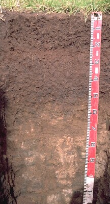 SW8 Profile |
| Subsoil | |||
| B21 | 15-25 cm | Dark reddish brown (5YR3/3); heavy clay loam (becoming light clay with depth); moderate medium blocky, parting to moderate fine polyhedral structure; firm consistence moderately moist; pH 6.5; abrupt change to: | |
| B22 | 25-40 cm | Dark brown (7.5YR3/4); light medium clay; strong medium polyhedral, parting to strong fine polyhedral structure, smooth faced peds; very firm consistence dry; pH 6.5; gradual change to: | |
| B23 | 40-50 cm | Dark brown (7.5YR3/2); medium clay; strong coarse blocky, parting to strong fine polyhedral structure; firm consistence slightly moist; roots to 50cm; pH 7.1; gradual change to: | |
| B/C | 50-70 cm | Dark brown (7.5YR3/2); fine sandy clay loam; very firm to strong consistence dry; contains a common (20%) amount of weathered basalt and volcanic ash; pH 8.0: | |
| C | 70+ cm | Volcanic ash deposits. |
Key Profile Features:
- Lack of strong texture contrast between surface (A) horizons and subsoil (B21) horizon.
- Moderately deep soil profile (ie. 70 cm) overlying volcanic ash deposits.
Soil Profile Characteristics:
pH | Salinity Rating | |||
Surface (A1 horizon) | Slightly Acid | Low | Sodic | None |
Subsoil (B21 horizon) | Slightly Acid | Very Low | Marginally Sodic | None |
Deeper Subsoil (at 50-70 cm) | Moderately Alkaline | Moderate | Non-Sodic | None |
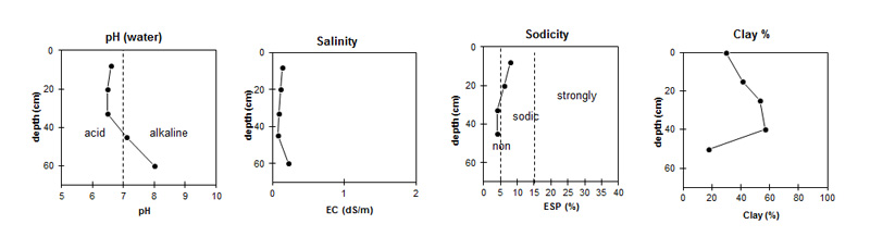
| The surface (A) horizons and upper subsoil are slightly acid. The deeper subsoil is slightly alkaline becoming moderately alkaline at depth. |
|
|
|
Horizon | Horizon Depth (cm) | pH (water) | pH (CaCl2) | EC 1:5 | Exchangeable Cations | |||
Ca | Mg | K | Na | |||||
meq/100g | ||||||||
A1 | 0-15 | 6.6 | 5.6 | 0.14 | 7.3 | 7.7 | 0.71 | 1.3 |
B21 | 15-25 | 6.5 | 5.5 | 0.11 | 6.4 | 10 | 0.68 | 0.95 |
B22 | 25-40 | 6.5 | 5.5 | 0.09 | 7.4 | 19 | 0.85 | 1.1 |
B23 | 40-50 | 7.1 | 5.9 | 0.08 | 8.2 | 28 | 0.89 | 1.1 |
B/C | 50-70 | 8.0 | 7.2 | 0.22 | 11 | 26 | 0.83 | 1.7 |
Horizon | Horizon Depth (cm) | Organic Carbon % | Wilting Point pF4.2 | Coarse Sand (0.2- 2.0 mm) | Fine Sand (0.02- 0.2 mm) | Silt (0.002- 0.02 mm) | Clay (<0.002 mm) |
A1 | 0-15 | 2.4 | 16.1 | 7.0 | 34.8 | 21.0 | 30.0 |
B21 | 15-25 | 1.4 | 17.9 | 7.0 | 31.5 | 14.5 | 41.0 |
B22 | 25-40 | 24.6 | 6.7 | 21.8 | 11.0 | 53.5 | |
B23 | 40-50 | 30.5 | 6.3 | 18.4 | 10.5 | 57.0 | |
B/C | 50-70 | 23.7 | 23.4 | 36.0 | 14.0 | 17.5 |
Management Considerations:
Whole Profile
- Plant available water capacity (PAWC) is considered to be low (estimated at 85 mm) for this soil profile. This is based on available laboratory data. Effective rooting depth will be restricted by the compacted ash deposits in the deeper subsoil. Most roots in the soil pit were observed to 50 cm depth.
- The inherent fertility (based on the sum of the exchangeable basic cations) of the surface horizons is moderate-high.
- The surface soil is reasonably well structured (parting to fine blocky structure) which should allow for good root proliferation.
- Due to the relatively high clay content in the surface horizon, such soils may be prone to compaction if excessively disturbed (eg. cultivation, trafficking) whilst in a moist-wet condition (ie wetter than the plastic limit).
- Although non-sodic, the upper subsoil disperses slightly (strongly after remoulding). Disturbance to this horizon by deep tillage (when in a moist to wet condition) may result in some structural degradation occurring.
- Exchangeable magnesium levels are high in the subsoil horizons (ie. > 45%). Values of exchangeable magnesium to Cation Exchange Capacity of over 20 % can induce potassium deficiency in some soils (Baker et al. 1993).
Profile Described By: Mark Imhof, Austin Brown, Paul Rampant, Graeme Ward and Ruth Lourey (April 1996).