Victorian Resources Online (archived)
SW84
Location: Warncoort
Australian Soil Classification: Episodic-Endocalcareous, Massive, Grey VERTOSOL
General Landscape Description: Gently undulating plain.
Site Description: Flat.
Geology: Basalt plain.
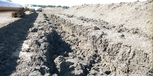
SW84 Landscape
Soil Profile Morphology:
Surface Soil
| A1 | 0-10 cm | Very dark grey (10YR3/1 moist); hardsetting surface condition with cracking; massive; clay loam; strong consistence dry; pH 6.8: | 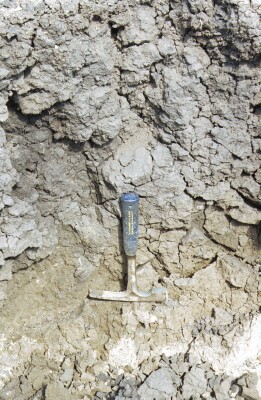 SW84 Profile |
| Subsoil | |||
| B21ss | 10-60 cm | Very dark grey (10YR3/1 moist); medium clay; prominent large slickensides; strong consistence dry; pH 8.3: | |
| B22ss | 60-80 cm | Dark grey (10YR4/1 moist); medium clay; strong consistence dry; slightly calcareous; pH 9.1; clear change to: | |
| B23k | 80-100 cm | Clay loam; soft carbonate; pH 9.5; abrupt change to: | |
| B24ssg | 100+ cm | Light brownish grey (2.5Y6/2 moist) with faint brownish yellow (10YR6/6 moist) mottles common; light clay; thick lenticular structure; strong consistence dry; moderately calcareous in patches; pH 9.2. |
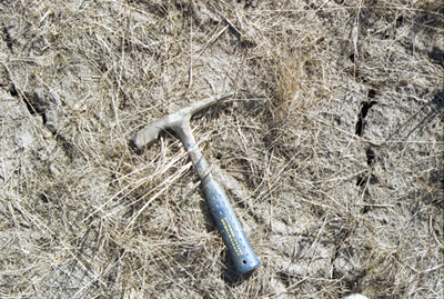
SW84 Surface cracking
Key Profile Features:
- High (>35%) clay content throughout the soil profile.
- Vertic features (slickensides and lenticular peds) in subsoil.
Soil Profile Characteristics:
pH | Salinity Rating | |||
Surface (A1 horizon) | Slightly Acid | Low | Sodic | Strong1 |
Subsoil (B21 horizon) | Moderately Alkaline | Medium | Strongly Sodic | Strong1 |
Deeper Subsoil (at 80-100 cm) | Very Strongly Alkaline | High - Very High | Strongly Sodic | None2 |
| 1 Complete dispersion after remoulding. 2 No aggregate dispersion due to high levels of soluble salts, slight dispersion after remoulding. | ||||
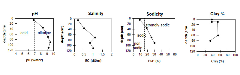
| The surface soil is slightly acid. The subsoil is moderately alkaline becoming very strongly alkaline with depth. | Salinity rating is low in the surface becoming medium in the subsoil and high to very high in the deeper subsoil. |
| The clay content increases markedly at the A/B boundary. |
Horizon | Horizon Depth (cm) | pH (water) | pH (CaCl2) | EC 1:5 | NaCl % | Exchangeable Cations | |||
Ca | Mg | K | Na | ||||||
meq/100g | |||||||||
A1 | 0-10 | 6.8 | 5.8 | 0.18 | 5.7 | 14 | 0.85 | 2.8 | |
B21 | 10-60 | 8.3 | 7.4 | 0.5 | 0.07 | 7.2 | 20 | 1.2 | 6.7 |
B22 | 60-80 | 9.1 | 8.5 | 1.1 | 0.16 | 6.3 | 21 | 1.1 | 10 |
B23 | 80-100 | 9.5 | 8.7 | 0.83 | 0.11 | 3.9 | 9.7 | 0.5 | 6 |
B24 | 100+ | 9.2 | 8.5 | 1 | 0.16 | ||||
Horizon | Horizon Depth (cm) | Organic Carbon % | Nitrogen % | Exchangeable Acidity meq/100g | Field Capacity pF2.5 | Wilting Point pF4.2 | Coarse Sand (0.2- 2.0 mm) | Fine Sand (0.02- 0.2 mm) | Silt (0.002- 0.02 mm) | Clay (<0.002 mm) |
A1 | 0-10 | 1.5 | 0.11 | 7.6 | 36.5 | 19.1 | 16 | 26 | 17 | 37 |
B21 | 10-60 | 54.9 | 28.3 | 7 | 19 | 19 | 53 | |||
B22 | 60-80 | 53.9 | 32.7 | 7 | 20 | 18 | 54 | |||
B23 | 80-100 | 32.7 | 16.2 | 7 | 10 | 9 | 33 | |||
B24 | 100+ |
Management Considerations:
Surface (A) Horizons
- The surface soil is sodic and disperses completely after remoulding. Care should be taken to avoid disturbing the surface horizon (i.e. trafficking, tillage, over-stocking) when the soil is in a moist condition. Also, raindrop impact on bare soil will exacerbate the hardsetting nature of the soil and will result in surface sealing and/or crust development.
- Tillage of cracking clay soils should be avoided if the soil is wet (i.e. wetter than the plastic limit). At such moisture conditions, excessive tillage, trafficking or over stocking could result in structural damage (i.e. compaction, smearing) occurring. Ideally tillage and trafficking should take place when the soil is drier than the plastic limit.
- When the soil is dry, heavy rains will move from soil cracks. This rapid recharge can be valuable for the survival of plants near wilting. When wet, the soil will swell and further infiltration of water will be relatively slow.
- The subsoil has a high level of soluble salts, which will restrict the growth of salt-sensitive species.
Notes
Situated in an area of lower drainage or plateau. Very vertic soil, cracking to surface and pugging. Collapsed trench but profile too dry and cracked to pick back effectively
Profile Described By: Richard McEwan (March 1999).