Victorian Resources Online (archived)
WCSS06
Location: Bellarine
Australian Soil Classification: Hypercalcic, Mottled-Subnatric, Brown SODOSOL
General Landscape Description: Rises.
Site Description: Upper slope (8% slope) of a hill slope.
Geology: Tertiary (Neogene) sediments, poorly consolidated ferruginised sandstone.
Land Use: Vineyard.

WCSS06 Landscape
Soil Profile Morphology:
Surface Soil
| A11 | 0-15 cm | Dark brown (7.5YR3/2); light sandy loam; weak structure; rough faced peds; weak consistence dry; pH 6.3; clear change to: | 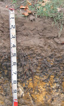 WCSS06 Profile WCSS06 Profile |
| A12 | 15-25 cm | Dark brown (7.5YR3/2); heavy loamy sand; massive; earthy fabric; weak consistence dry; contains a few coarse (6-22 mm in size) ferruginous and ferro-manganiferous concretions; pH 5.4; clear change to: | |
| A2 | 25-40 cm | Brown (7.5YR4/2); heavy loamy sand; massive structure; earthy fabric; weak consistence dry; very coarse ferruginous nodules common; many distinct clay cutans present; pH 5.9; clear and wavy change to: | |
| Subsoil | |||
| B21 | 40 - 70 cm | Yellowish brown (10YR5/4) with many very dark grey (10YR3/1) and yellowish red (5YR5/8) mottles; medium heavy clay; strong very coarse angular blocky, parting to strong medium angular blocky structure; smooth faced peds; very firm consistence moderately moist; contains a few very coarse soft calcareous segregations in patches as well as very few coarse fragments; many distinct clay cutans evident; pH 6.4; changing to: | |
| C1 | 70 – 90 cm | Yellowish brown (10YR5/6) with many very dark greyish brown (10YR3/2) and very pale brown (10YR7/3) mottles; sandy clay; moderate fine polyhedral structure; rough faced peds; contains many very coarse calcareous soft segregations, as well as many angular ferruginised sandstone fragments; some distinct infill evident; highly calcareous; pH 8.7; changing to: | |
| C2 | 90 – 130+ cm | Yellowish brown (10YR5/6) with many very dark greyish brown (10YR3/2) and very pale brown (10YR7/3) mottles; sandy clay; massive; contains a common amount of very coarse soft calcareous segregations; contains abundant ferruginised sandstone fragments; some distinct clayey infills evident; highly calcareous; pH 8.8. |
Soil Profile Characteristics:
pH | Salinity Rating | |||
Surface (A1 horizon) | Slightly Acid | Low | Non-Sodic | None 1 |
Subsoil (B21 horizon) | Slightly Acid | Low | Sodic | Moderate1 |
Deeper Subsoil (at 90-130+ cm) | Strongly Alkaline | Low | Sodic | Strong |
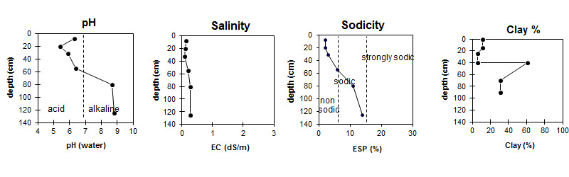
| The surface and upper subsoil is slightly acidic. The deeper subsoil is strongly alkaline. | The salinity rating is low throughout the profile. | The surface is non-sodic. The subsoil is sodic, with sodicity increasing with depth. | There is a sharp increase in clay content at the surface / subsoil boundary. |
Horizon | Horizon Depth (cm) | pH (water) | pH (CaCl2) | EC dS/m | Sodium Chloride % | Exchangeable Cations | |||
Ca | Mg | K | Na | ||||||
meq/100g | |||||||||
A11 | 0-15 | 6.3 | 5.7 | 0.14 | 5.6 | 1.4 | 0.82 | 0.33 | |
A12 | 15-25 | 5.4 | 4.8 | 0.1 | 2.6 | 0.66 | 0.24 | 0.2 | |
A2 | 25-40 | 5.9 | 5.2 | 0.09 | 2.6 | 0.61 | 0.23 | 0.25 | |
B2 | 40-70 | 6.4 | 5.6 | 0.2 | 11 | 9.0 | 0.48 | 1.8 | |
C1 | 70-90 | 8.7 | 8.1 | 0.27 | 0.01 | 6.1 | 4.7 | 0.34 | 1.4 |
C2 | 90-130 | 8.8 | 8.2 | 0.26 | 0.01 | 4.7 | 3.5 | 0.24 | 1.4 |
Horizon | Horizon Depth (cm) | Oxidisable Organic Carbon % | Nitrogen g/100g | Exchangeable Aluminium mg/kg | Exchangeable Acidity meq/100g | Field Capacity pF2.5 | Wilting Point pF4.2 | Coarse Sand (0.2-2.0 mm) | Fine Sand (0.02-0.2 mm) | Silt (0.002-0.02 mm) | Clay (<0.002 mm) |
A11 | 0-15 | 2.2 | 0.13 | <10 | 5.1 | 16.4 | 5.3 | 7 | 71 | 6 | 11 |
A12 | 15-25 | 1.3 | 0.06 | <10 | 5.4 | 14.7 | 4.5 | 10 | 72 | 4 | 11 |
A2 | 25-40 | 0.83 | <0.05 | <10 | 4.8 | 14.5 | 4.6 | 25 | 62 | 9 | 6 |
B2 | 40-70 | 1.1 | 0.1 | <10 | 10 | 42.4 | 23.1 | 2 | 30 | 3 | 61 |
C1 | 70-90 | 23.8 | 13.0 | 6 | 52 | 2 | 31 | ||||
C2 | 90-130 |
Profile Described By: David Rees and Siegfried Engleitner (March 2010).