Victorian Resources Online (archived)
SW100
Location: Batesford
Australian Soil Classification: Calcic, Hypernatric, Brown SODOSOL
General Landscape Description: Undulating rises.
Site Description: Open depression.
Geology: Moorabool Viaduct alluvium.
Soil Profile Morphology:
Surface Soil
| Ap | 0-25 cm | Reddish yellow mottled; sand; hardsetting (recently deposited material); abrupt change to: | 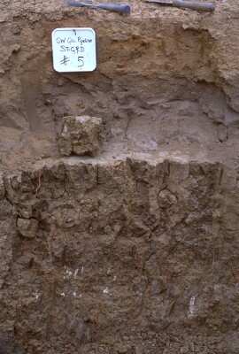 SW100 Profile - Note: Surface stripped from soil profile. |
| A1b | 25-30 cm | Grey; loamy sand; clear change to: NOTE: Buried A horizon. | |
| A2 | 30-55 cm | Greyish brown (10YR5/2 moist) conspicuously bleached (10YR7/1 dry); hardsetting sand; apedal structure; pH 6.4; sharp change to: | |
| Subsoil | |||
| B21t | 55-90 cm | Brown (10YR4/3 moist); medium clay; very coarse (>150 mm) prismatic, parting to coarse polyhedral structure; pH 8.2; gradual change to: | |
| B22t(k) | 90 + cm | Mottled brown and grey; clay loam; few (<5%) small calcium carbonate (CaCO3) accumulations at 1.2 metres depth and concentrated around macropores; pH 9.5. |
Key Profile Features:
- Conspicuously bleached subsurface (A2) horizon.
- Strong texture contrast between surface (A) horizons and subsoil (B21) horizon.
Soil Profile Characteristics:
pH | Salinity Rating | |||
Surface | Striped so not sampled | - | - | - |
Sub-Surface (A2 horizon) | Slightly Acid | Low | Strongly Sodic | - |
Subsoil (B21 horizon) | Moderately Alkaline | Low | Strongly Sodic | Strong-Complete |
Deeper Subsoil (at 100 cm) | Very Strongly Alkaline | Medium-High | Strongly Sodic | - |
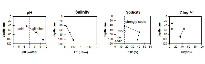
| The surface is slightly acid. The subsoil is moderately alkaline becoming very strongly alkaline at depth. | Salinity rating is low in the surface and upper subsoil becoming medium to high in the subsoil. | The soil is strongly sodic in the sub-surface and subsoil. | The clay content increases markedly at the A/B boundary. |
Horizon | Sample Depth (cm) | pH (water) | pH (CaCl2) | EC 1:5 | NaCl % | Exchangeable Cations | |||
Ca | Mg | K | Na | ||||||
meq/100g | |||||||||
Ap | 0-30 | - | - | - | - | - | - | - | |
A2 | 30-55 | 6.4 | 5.6 | 0.11 | 0.45 | 0.88 | 0.05 | 0.57 | |
Bt | 60-80 | 8.2 | 7 | 0.3 | 0.02 | 4.9 | 7.5 | 0.7 | 8.9 |
B22 | 95-110 | 9.5 | 8.5 | 0.52 | 0.05 | 4.7 | 7.3 | 0.6 | 7.7 |
Horizon | Sample Depth (cm) | Exchangeable Acidity meq/100g | Coarse Sand (0.2- 2.0 mm) | Fine Sand (0.02- 0.2 mm) | Silt (0.002- 0.02 mm) | Clay (<0.002 mm) |
Ap | 0-30 | - | - | - | - | - |
A2 | 30-55 | 1.6 | 33 | 50 | 8 | 8 |
Bt | 60-80 | 17 | 27 | 7 | 46 | |
B22 | 95-110 | 19 | 35 | 10 | 33 |
Management Considerations:
Soil (B) Horizons
- The dense and coarsely structured subsoil is strongly sodic and disperses strongly in water. This will result in restricted root and water movement into the subsoil.
Profile Described By: Richard McEwan (February 1999).