Victorian Resources Online (archived)
SW101
Locaton: Lara
Australian Soil Classification: Episodic-Endocalcareous, Self-Mulching, Black VERTOSOL
General Landscape Description: Alluvial plain.
Site Description: Flat below monocline.
Geology: Quaternary Basalt (Lovely Banks Monocline)
 SW101 Landscape |
Soil Profile Morphology:
Surface Soil
| A1 | 0-10 cm | Very dark grey (5YR3/1 moist); light medium clay; self-mulching surface condition; fine structure; rough faced peds; pH 6.9; clear and smooth change to: | 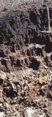 SW101 Profile - Note: Surface stripped from soil profile. |
| Subsoil | |||
| B21t | 10-30/40 cm | Very dark grey (5YR3/1 moist); medium clay; strong polyhedral structure; prominent small slickensides; pH 8.5; clear and wavy change to: | |
| B22ss | 30/40-65/75 cm | Dark reddish brown (5YR3/2 moist); prismatic, polyhedral and lenticular structure; frequent large (>300 mm) slickensides; pH 9.2; abrupt to clear and wavy change to: | |
| B23kss | 65/75+ cm | Dark greyish brown (2.5Y4/2 moist) or grey (2.5Y5/1); light clay; very large slickensides (up to 1 m); abundant large patches of whitish soft carbonate. |
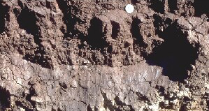
Large slickensides in deeper subsoil.
Key Profile Features:
- Self-mulching surface soil.
- High clay content throughout the soil profile.
- Vertic features (slickensides and lenticular peds).
- Calcium carbonate segregations in deeper subsoil.
Soil Profile Characteristics:
pH | Salinity Rating | |||
Surface (A1 horizon) | Slightly Acid | Low | Strongly Sodic | None1 |
Subsoil (B21 horizon) | Moderately Alkaline | High | Strongly Sodic | Strong-Complete |
Deeper Subsoil (at 40-60 cm) | Very Strongly Alkaline | Very High | Strongly Sodic | Strong-Complete |
| 1 Complete dispersion after remoulding. | ||||
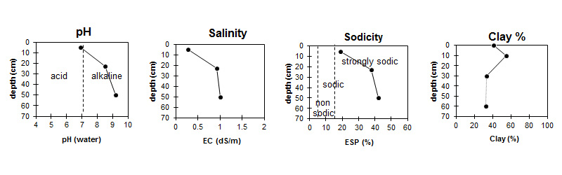
| The surface is slightly acid. The subsoil is moderately alkaline becoming very strongly alkaline at depth. | Salinity rating is low in the surface. The upper subsoil is high becoming very high in the deeper subsoil. | The profile is strongly sodic throughout. | The clay content is high throughout the profile. |
Horizon | Sample Depth (cm) | pH (water) | pH (CaCl2) | EC 1:5 | NaCl % | Exchangeable Cations | |||
Ca | Mg | K | Na | ||||||
meq/100g | |||||||||
A1 | 0-10 | 6.9 | 5.9 | 0.28 | 0.03 | 7.8 | 8.8 | 0.7 | 4 |
B21ss | 15-30 | 8.5 | 7.8 | 0.92 | 0.15 | 11 | 15 | 1 | 16 |
B22ss | 40-60 | 9.2 | 8.6 | 1 | 0.20 | 8.7 | 14 | 1 | 17 |
Horizon | Sample Depth (cm) | Exchangeable Acidity meq/100g | Organic Carbon % | Nitrogen % | Field Capacity pF2.5 | Wilting Point pF4.2 | Coarse Sand (0.2-2.0mm) | Fine Sand (0.02-0.2mm) | Silt (0.002-0.02mm) | Clay (<0.002mm) |
A1 | 0-10 | 12 | 2.5 | 0.24 | 42.1 | 23.4 | 6 | 24 | 21 | 41 |
B21ss | 15-30 | 74.2 | 36.7 | 3 | 11 | 23 | 55 | |||
B22ss | 40-60 | 61.4 | 34.3 | 5 | 22 | 36 | 33 |
Management Considerations:
Surface (A) Horizons
- The surface soil is sodic and disperses completely after remoulding. Care should be taken to avoid disturbing the surface horizon (i.e. trafficking, tillage, over-stocking) when the soil is in a moist condition. Also, raindrop impact on bare soil will exacerbate the hardsetting nature of the soil and will result in surface sealing and/or crust development.
- The relatively high wilting point (i.e. 19%) indicates that plants will be unable to fully utilise rains when the soil is dry.
- Tillage of cracking clay soils should be avoided if the soil is wet (i.e. wetter than the plastic limit). At such moisture conditions, excessive tillage, trafficking or over stocking could result in structural damage (i.e. compaction, smearing occurring). Tillage and trafficking should take place when the soil is drier than the plastic limit.
- When the soil is dry heavy rains will move down soil cracks. This rapid recharge can be reliable for that survival of plants near silting. When wet, the soil will swell and further infiltration of water will be relatively slow.
Subsoil (B) Horizons
- The subsoil displays vertic features (i.e. slickensides) which indicates that significant shrinking and swelling occurs during wetting and drying cycles. This may have engineering implications and is likely to explain the variability in surface horizon depth across the trench.
- The subsoil is strongly sodic and disperses freely. This is likely to result in restricted root and water movement into the subsoil.
Profile Described By: Richard McEwan (January 1999).