Victorian Resources Online (archived)
SW104
Location: Lara
Australian Soil Classification: Endocalcareous, Epipedal, Black VERTOSOL
General Landscape Description: Near level plain.
Site Description: Broad flat ridge slope <1%, easterly aspect.
Geology: Recent alluvium overlying Quaternary basalt.
Soil Profile Morphology:
Surface Soil
| Ap | 0-20 cm | Dark brown (7.5YR3/2 moist and 7.5YR4/2 dry); light clay; many fine calcareous nodules; pH 8.5; abrupt change to: | 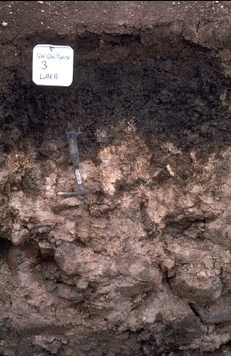 SW104 Profile - Note: Surface stripped from soil profile. |
| Subsoil | |||
| B21tss | 20-40 cm | Very dark greyish brown (10YR3/2); medium heavy clay; fine prismatic parting to blocky structure; slickensides; pH 8.6; wavy change to: | |
| B22tss | 40-50 cm | Brown (7.5YR4/3); angular blocky to lenticular structure: | |
| B23k/C | 50+ cm | Soft whitish calcium carbonate [CaCO3] over fractured basalt; highly calcareous in fissures. |
Key Profile Features:
- High (>35%) clay content throughout the soil profile.
- Vertic features (slickensides) prominent.
- Calcium carbonate segregations in deeper subsoil.
- Shallow to moderate soil profile depth – overlying fractured basalt.
Soil Profile Characteristics:
pH | Salinity Rating | |||
Surface (A1 horizon) | Moderately Alkaline | Low | Non-Sodic | None |
Subsoil (B21 horizon) | Strongly Alkaline | Low | Sodic | None1 |
| 1 Strong dispersion after remoulding. | ||||
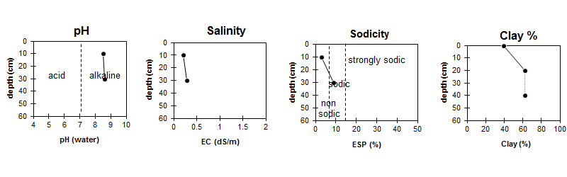
| The surface is moderately alkaline. The subsoil is strongly alkaline. | Salinity rating is low throughout the profile.. | The soil is non sodic in the surface and sodic in the subsoil. | The clay content is high throughout the profile. |
Horizon | Sample Depth (cm) | pH (water) | pH (CaCl2) | EC 1:5 | NaCl % | Exchangeable Cations | |||
Ca | Mg | K | Na | ||||||
meq/100g | |||||||||
Ap | 0-20 | 8.5 | 7.9 | 0.2 | 27 | 5.5 | 1.1 | 1 | |
B21 | 20-40 | 8.6 | 7.8 | 0.28 | <0.01 | 20 | 11 | 1.1 | 2.9 |
Horizon | Sample Depth (cm) | Organic Carbon % | Nitrogen % | Field Capacity pF2.5 | Wilting Point pF4.2 | Coarse Sand (0.2- 2.0 mm) | Fine Sand (0.02- 0.2 mm) | Silt (0.002- 0.02 mm) | Clay (<0.002 mm) |
Ap | 0-20 | 1.6 | 0.15 | 37.1 | 18.8 | 6 | 28 | 21 | 39 |
B21 | 20-40 | 56.1 | 31.2 | 4 | 12 | 13 | 62 |
Management Considerations:
Surface (A) Horizons
- The relatively high wilting point (i.e. 19%) indicates that plants will be unable to fully utilise light rains, when the soil is dry.
- Tillage of cracking clay soils should be avoided if the soil is wet (i.e. wetter than the plastic limit). At such moisture conditions, excessive tillage, trafficking or over stocking could result in structural damage (i.e. compaction, smearing) occurring. Ideally tillage and trafficking should take place when the soil is drier than the plastic limit.
- When the soil is dry, heavy rains will move down soil cracks. This rapid recharge can be valuable for the survival of plants near wilting. When wet, the soil will swell and further infiltration of water will be relatively slow.
Subsoil (B) Horizons
- The subsoil is strongly alkaline, which indicates that some nutrients (e.g. iron, manganese, copper, zinc) may be poorly available to plants.
Notes
- Line between Forest Rd and Railway line to the East confirms that calcareous topsoil is associated with east facing slope of the land straddled by Forest Rd. Grey prismatic/slickensided deeper subsoil occurs in pockets. Shallowest soil is nearest the road (sometimes <30 cm). Soil becomes darker towards railway line.