Victorian Resources Online (archived)
SW39
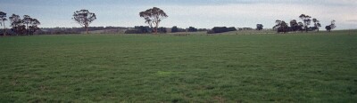
Location: Irrewillipe.
Australian Soil Classification: Melacic (& Vertic), Eutrophic, Black DERMOSOL
Map Unit: Map Unit 116 (Maher and Martin, 1987).
General Landscape Description: Level plain (possibly a terrace).
Site Description: Grazing paddock (dairy).
Geology: Quaternary sediments overlying Tertiary - Moorabool Viaduct Formation.
 SW39 Landscape |
Soil Profile Morphology:
Surface Soil
| A1 | 0-25 cm | Very dark brown (10YR2/2); very fine sandy clay loam; weak coarse blocky, parting to moderate coarse blocky structure; firm consistence moist; pH 5.4: | 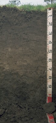 SW39 Profile |
| A21 | 25-40 cm | Very dark greyish brown (10YR3/2), sporadically bleached; very fine sandy clay loam; weak coarse blocky structure; weak consistence moist; pH 5.7: | |
| A22 | 40-65 cm | Dark greyish brown (10YR4/2) with brownish yellow (10YR6/6) mottles, sporadically bleached; fine sandy clay loam (heavy); weakly structured; weak consistence moist; pH 5.6: | |
| Subsoil | |||
| B21 | 65-90 cm | Very dark brown (10YR2/2); light clay (fine sandy); moderate coarse blocky structure; firm consistence moist; pH 5.6: | |
| B22 | 90+ cm | Very dark brown (10YR2/2) with a few yellowish brown (10YR5/8) mottles; medium clay; strong medium lenticular, parting to strong very fine lenticular structure; firm consistence moist; pH 5.7. |
Key Profile Features:
- · Very high salinity in the surface soil.
Soil Profile Characteristics:
pH | Salinity Rating | |||
Surface (A1 horizon) | Strongly Acid | Very High- Extremely High | Non-Sodic | None |
Subsoil (B21 horizon) | Moderately Acid | High | Marginally Sodic | Slight |
Deeper Subsoil (at 90+ cm) | Moderately Acid | Moderate-High | Marginally Sodic | None |
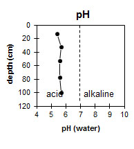 The surface horizon is strongly acid. The subsoil is moderately acid. | 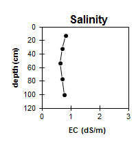 The salinity rating is very high to extremely high at the surface. The subsoil is high becoming moderate to high with depth. | 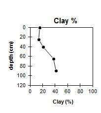 The clay content increases gradually with depth. |
Horizon | Horizon Depth (cm) | pH (water) | pH (CaCl2) | EC (dS/m) | NaCl % | Exchangeable Cations | |||
Ca | Mg | K | Na | ||||||
meq/100g | |||||||||
A1 | 0-25 | 5.4 | 4.9 | 0.81 | 0.18 | 4 | 1.5 | 0.2 | 0.4 |
A21 | 25-40 | 5.7 | 5.1 | 0.71 | 0.016 | 2.4 | 1.3 | 0.2 | 0.4 |
A22 | 40-65 | 5.6 | 5 | 0.64 | 0.015 | 2.5 | 1.2 | <0.1 | 0.4 |
B21 | 65-90 | 5.6 | 5.1 | 0.7 | 0.16 | 3.2 | 3.8 | <0.1 | 1 |
B22 | 90+ | 5.7 | 5.2 | 0.77 | 0.09 | 2.3 | 4.4 | <0.1 | 1.1 |
Horizon | Horizon Depth (cm) | Acidity meq/100g | Oxidisable Organic Carbon % | Total Nitrogen % | Field Capacity pF2.5 | Wilting Point pF4.2 | Coarse Sand (0.2- 2.0 mm) | Fine Sand (0.02- 0.2 mm) | Silt (0.002- 0.02 mm) | Clay (<0.002 mm) |
A1 | 0-25 | 3.7 | 0.23 | 30 | 9.7 | 9 | 50 | 20 | 15 | |
A21 | 25-40 | 24.9 | 5.4 | 8 | 54 | 23 | 14 | |||
A22 | 40-65 | 22.3 | 5.4 | 9 | 55 | 16 | 21 | |||
B21 | 65-90 | 7.1 | 31.9 | 14.4 | 6 | 40 | 18 | 37 | ||
B22 | 90+ | 33.1 | 15.9 | 5 | 37 | 18 | 41 |
Management Considerations:
- Friable surface soils (and subsoils) occur where there is a build up of organic matter, (and to some extent iron rich clay complexes) generally in cooler wetter areas (less extreme wetting and drying cycling).
- Bleached A2 horizons (or subsurface soils) are a major feature of many of soils within the Corangamite CMA region. They are an indication of restricted drainage, poor soil structure (often massive) and low organic matter, nutrient and water holding capacity, nearly always in conjunction with a restrictive soil below such as a clayey soil or a pan (eg. coffee rock). These bleached horizons may act as conduit for subsurface flow, particularly on sloping ground. If the soil is dispersive then gypsum application would be suitable, while increasing organic matter and maintaining vegetative cover is important.
Profile Described By: Mark Imhof and Austin Brown (June 1998).