Victorian Resources Online (archived)
SW58
Location: Cooriemungle.
Australian Soil Classification: Humose, Kurosolic, Redoxic HYDROSOL
Site Description: Drained dairy grazing paddock.
General Landscape Description: Flat valley floor in dissected plain.
Geology: Quaternary alluvium derived from Gellibrand Marl and Hanson Plain Sand.
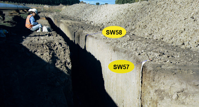 SW58 Landscape |
Soil Profile Morphology:
Surface Soil
| A1 | 0-30 cm | Very dark brown (10YR2/2); clay loam; weak medium polyhedral structure; weak consistence dry; pH 5.9; clear and smooth change to: | 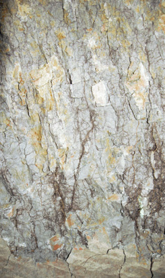 SW58 Profile. Note: Surface (A1) has been stripped from the soil profile. |
| Subsoil | |||
| B21 | 30-45 cm | Black (10YR2/1) with reddish yellow (5YR6/8) mottles common, mainly in root channels; medium clay; coarse polyhedral, parting to medium blocky structure; weak consistence dry; pH 5.3; abrupt and smooth change to: | |
| B22g | 45-75 cm | Dark grey (10YR4/1) with brownish yellow (10YR6/8) mottles common; medium clay; medium prismatic, parting to medium blocky structure; firm consistence dry; pH 5.5; clear and smooth change to: | |
| B23g | 75+ cm | Grey (10YR5/1) with many reddish yellow (7.5YR6/8) mottles; heavy clay; very coarse prismatic structure (larger at depth) parting to coarse blocky structure; very firm consistence dry; pH 5.8; strong sulphidic smell i.e. anaerobic. | |
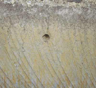
Drainage hole in profile.
Key Profile Features:
- Strong texture contrast between surface (A1) horizon and subsoil (B21) horizon.
Soil Profile Characteristics:
pH | Salinity Rating | |||
Surface (A1 horizon) | Moderately Acid | Low | Non-Sodic | None |
Subsoil (B21 horizon) | Strongly Acid | Low | Non-Sodic | None |
Deeper Subsoil (at 75-130 cm) | Moderately Acid | Low | Non-Sodic | None |
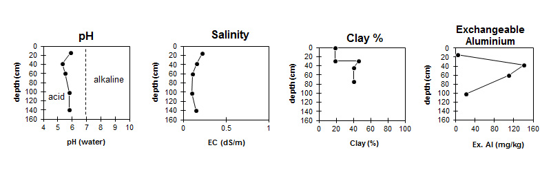
| The surface is moderately acid. The subsoil is strongly acid. | The salinity rating is low throughout the profile. | The clay content increases markedly at the surface / subsoil boundary. | Exchangeable Aluminium increases to very high levels in the subsoil. |
Horizon | Horizon Depth (cm) | pH (water) | pH (CaCl2) | EC (dS/m) | Exchangeable Cations | |||
Ca | Mg | K | Na | |||||
meq/100g | ||||||||
A1 | 0-30 | 5.9 | 5.4 | 0.22 | 12 | 2.8 | 0.4 | 0.46 |
B21 | 30-45 | 5.3 | 4.5 | 0.16 | 8.2 | 5.2 | 0.38 | 0.8 |
B22 | 45-75 | 5.5 | 4.6 | 0.11 | 5.1 | 5.2 | 0.34 | 0.71 |
B23g | 75-130 | 5.8 | 4.8 | 0.1 | 3.4 | 3.8 | 0.23 | 0.54 |
B23g | 130-150 | 5.8 | 5 | 0.15 | ||||
Horizon | Horizon Depth (cm) | Oxidisable Organic Carbon % | Total Nitrogen % | Exchangeable Aluminium mg/kg | Exchangeable Acidity meq/100g | Field Capacity pF2.5 | Wilting Point pF4.2 | Coarse Sand (0.2-2.0 mm) | Fine Sand (0.02-0.2 mm) | Silt (0.002-0.02 mm) | Clay (<0.002 mm) |
A1 | 0-30 | 4.8 | 0.4 | <10 | 13 | 36 | 15 | 5 | 46 | 21 | 19 |
B21 | 30-45 | 140 | 18 | 39 | 22 | 5 | 20 | 21 | 46 | ||
B22 | 45-75 | 110 | 12 | 36 | 24 | 9 | 28 | 20 | 40 | ||
B23g | 75-130 | 22 | 5.4 | 25 | 13 | 13 | 39 | 23 | 26 | ||
B23g | 130-150 |
Management Considerations:
Whole Profile
- The soil profile will be saturated for a number of months during most years. Drainage will be required for agricultural use.
- An additional subsoil horizon was sampled 10 m west of profile called SW57 to ensure adequate coverage of soil variability at this site.
- Exchangeable aluminium levels are reasonably high in the strongly acid upper subsoil. This may restrict the growth of aluminium sensitive species.
Profile Described By: Mark Imhof and Richard MacEwan (April 1999).