Victorian Resources Online (archived)
SW59
Location: Simpson.
Australian Soil Classification: Vertic, Sesquic, Semiaquic PODOSOL
Great Soil Group: podzol
General Landscape Description: Dissected Tertiary Sediments - Undulating Low Hills.
Sites description: Valley side, crest.
Geology: Veneer of Tertiary Hanson Plain Sand overlying Gellibrand Marl colluvium.
Land Use: Dairy cattle grazing.
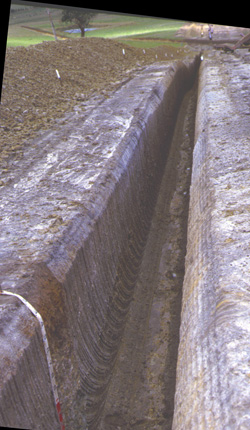
SW59 Landscape
Soil Profile Morphology:
Surface Soil
| A1 | 0-15 cm | Black (2.5Y2.5/1); sandy loam; pH 5.6; smooth change to: | 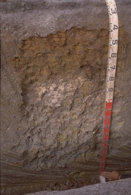 SW59 Profile. Note: Surface (A1) horizon has been stripped |
| A2 | 15-30 cm | Intermittent horizon; conspicuously bleached; clear and wavy change to: | |
| Subsoil | |||
| B21s | 15/30-60 cm | Mottled yellowish brown (10YR5/8) and very dark greyish brown (10YR3/2); sandy clay loam; weak very fine polyhedral structure; weak to firm consistence dry; weakly cemented 'coffee rock'; pH 5.3; gradual and wavy change to: | |
| B22g | 60-90 cm | Light olive brown (2.5Y5/4) with prominent yellow (10YR7/8) to yellowish brown (10YR5/8) mottles; sandy clay; very coarse polyhedral, parting to coarse blocky structure; whitish sand coatings on the larger ped faces; pH 5.5; clear and wavy change to: | |
| B23gss | 90+ cm | Light greenish grey (5GY7/1) with brownish yellow (10YR6/8) mottles; heavy clay; very coarse polyhedral, parting to coarse blocky structure; slickensides (>50 mm in size) present; pH 6.3. | |
Key Profile Features:
- Strong texture contrast between surface (A) horizons and subsoil (B21) horizon.
- Water logging in the subsoil.
pH | Salinity Rating | |||
Surface (A1 horizon) | Moderately Acid | Low | Non-Sodic | None |
Subsoil (B21 horizon) | Strongly Acid | Low | Non-Sodic | None |
Deeper Subsoil (at 90+ cm) | Slightly Acid | Low | - | - |
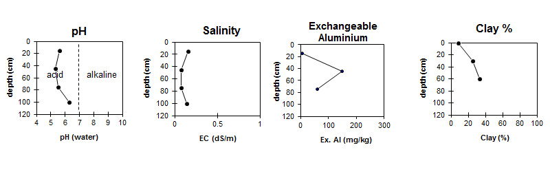
| The surface is moderately acid. The subsoil is strongly acid becoming slightly acid with depth. | The salinity rating is low throughout the profile. | Exchangeable Aluminium increases to very high levels in the subsoil. | The clay content increases slightly down the profile. |
Horizon | Horizon Depth (cm) | pH (water) | pH (CaCl2) | EC (dS/m) | Exchangeable Cations | |||
Ca | Mg | K | Na | |||||
meq/100g | ||||||||
A1 | 0-15 | 5.6 | 5 | 0.16 | * 5.8 | 0.87 | 0.26 | 0.33 |
| Sporadic A2 not sampled | ||||||||
B21 | 15/30-60 | 5.3 | 4.5 | 0.08 | 0.83 | 1 | 0.12 | 0.27 |
B22 | 60-90 | 5.5 | 4.6 | 0.08 | 1.2 | 2.8 | 0.14 | 0.41 |
B3 | 90+ | 6.3 | 5.2 | 0.14 | ||||
* High levels of Exchangeable Calcium could be due to liming.
Horizon | Horizon Depth (cm) | Oxidisable Organic Carbon % | Total Nitrogen % | Exchangeable Aluminium mg/kg | Exchangeable Acidity meq/100g | Field Capacity pF2.5 | Wilting Point pF4.2 | Coarse Sand (0.2-2.0 mm) | Fine Sand (0.02-0.2 mm) | Silt (0.002-0.02 mm) | Clay (<0.002 mm) |
A1 | 0-15 | 4.6 | 0.26 | <10 | 12 | 20 | 9 | 24 | 49 | 11 | 9 |
| Sporadic A2 not sampled | |||||||||||
B21 | 15/30-60 | 150 | 11 | 20 | 11 | 18 | 48 | 2 | 25 | ||
B22 | 60-90 | 61 | 5.7 | 22 | 12 | 18 | 44 | 4 | 33 | ||
B3 | 90+ | ||||||||||
Management Considerations:
Subsoil (B) Horizons
- Exchangeable aluminium levels are quite high in the strongly acid upper subsoil. This may restrict the growth of aluminium sensitive species.
- Contrast gleyed subsoil - sandy clay to heavy clay represents transition from overlying Hanson Plain Sand to underlying Gellibrand Marl.
Profile Described By: Mark Imhof and Richard MacEwan (March 1999)