Victorian Resources Online (archived)
Archived content — This page contains material from the Victorian Resources Online (VRO) website. It is no longer maintained and is provided for reference only. This content is hosted by CeRDI and is not endorsed by Agriculture Victoria.
Sitemap
2.1 Tomahawk Creek
|
This information has been developed from the publications:
- Sites of Geological and Geomorphological Significance in the Western Region of Melbourne (1986) by Neville Rosengren
- Sites of Geological and Geomorphological Significance on the Coast of Port Phillip Bay (1988) by Neville Rosengren.
- Sites of Geological and Geomorphological Significance in the Shire of Otway (1984) by Neville Rosengren.
Geological heritage sites, including sites of geomorphological interest and volcanic heritage sites, are under regular revision by the Geological Society of Australia, especially in the assessment of significance and values. Reference should be made to the most recent reports. See the Earth Science Heritage (external site) section of the Geological Society of Australia website for details of geological heritage reports, and a bibliography. |
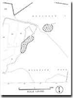
| Location: | 2-045394. Eleven kilometres east of Simpson. |
Access: |
Coradjil Road. |
Ownership: |
Crown land. |
Geology/Geomorphology: |
Tomahawk Creek is incised into the Gellibrand Marl and the formation is poorly exposed in a section of the creek bank. At this site, there is a short swampy sector along the valley extending into the mouth of a small tributary creek. |
Significance: |
Local. This is typical of the Tomahawk Creek drainage system. |