Victorian Resources Online (archived)
19.8 Carisbrook Falls
This information has been developed from the publications:
|
| Location: | 19-442142. Three kilometres west of Cape Patton. | 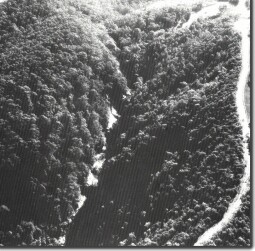 Carisbrook Falls |
Access: | Great Ocean Road. | |
Ownership: | Mainly Crown Land. | |
Geology/Geomorphology: | The Carisbrook Creek flows across beds of marine arkose that outcrop in the stream channel and dip in a downstream direction at 15o to 25o. This intersection gives rise to a series of rapids, cascades and small waterfalls along a stream distance of 500 metres that involves a total vertical fall of almost 200 metres. A number of structural controls on the configuration of the stream bed and the walls of the confining gorge are evident including the orientation of the channel, the height and slope of several small falls and cascades and the development of potholes and incised channel sectors. | |
Significance: | State. This is the longest and highest rapid and cascade section of any stream in the study area. It is an outstanding site to study the relationship between structure and stream development. | |
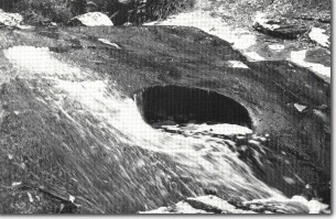 Abrasion pothole - Carisbrook Falls. |
