Victorian Resources Online (archived)
Archived content — This page contains material from the Victorian Resources Online (VRO) website. It is no longer maintained and is provided for reference only. This content is hosted by CeRDI and is not endorsed by Agriculture Victoria.
Sitemap
15.1 Chapple Creek Backswamp
|
This information has been developed from the publications:
- Sites of Geological and Geomorphological Significance in the Western Region of Melbourne (1986) by Neville Rosengren
- Sites of Geological and Geomorphological Significance on the Coast of Port Phillip Bay (1988) by Neville Rosengren.
- Sites of Geological and Geomorphological Significance in the Shire of Otway (1984) by Neville Rosengren.
Geological heritage sites, including sites of geomorphological interest and volcanic heritage sites, are under regular revision by the Geological Society of Australia, especially in the assessment of significance and values. Reference should be made to the most recent reports. See the Earth Science Heritage (external site) section of the Geological Society of Australia website for details of geological heritage reports, and a bibliography. |
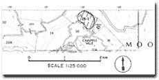
| Location: | 15-023220. Three hundred metres north-west of the road bridge at Chapple Vale. | |
Access: |
Mt McKenzie - Chapple Vale Road. |
Ownership: |
Private land. |
Geomorphology: |
The swamp occupies a depression below an old landslip on the north side of the confined floodplain of Chapple Creek. |
Significance: |
Local. Because the swamp is not drained or cleared, it represents the best unmodified flood plain swamp of Chapple Creek. The rate of transmission of water from the valley side through the wetland to the creek illustrates a major process of drainage development on the Tertiary sediments on the north western flank of the Otway Ranges. |