Victorian Resources Online (archived)
Archived content — This page contains material from the Victorian Resources Online (VRO) website. It is no longer maintained and is provided for reference only. This content is hosted by CeRDI and is not endorsed by Agriculture Victoria.
Sitemap
4.2 River Capture - Kawarren
This information has been developed from the publications:
- Sites of Geological and Geomorphological Significance in the Western Region of Melbourne (1986) by Neville Rosengren
- Sites of Geological and Geomorphological Significance on the Coast of Port Phillip Bay (1988) by Neville Rosengren.
- Sites of Geological and Geomorphological Significance in the Shire of Otway (1984) by Neville Rosengren.
Geological heritage sites, including sites of geomorphological interest and volcanic heritage sites, are under regular revision by the Geological Society of Australia, especially in the assessment of significance and values. Reference should be made to the most recent reports. See the Earth Science Heritage (external site) section of the Geological Society of Australia website for details of geological heritage reports, and a bibliography. |
| Location: | 4-269365. Two kilometres south east of Kawarren. | 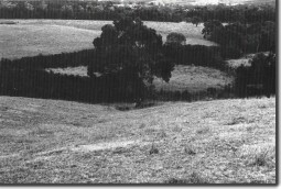
Stream capture site at Kawarren. |
Access: |
Kawarren East Road. |
Ownership: |
Private land. |
Geomorphology: |
A probable example of stream capture occurs on a small tributary of Love Creek. |
Significance: |
Local. This small feature clearly illustrates an unusual stage of drainage development. |