Victorian Resources Online (archived)
Birregurra Land System
Download the pdf version of this document: Birregurra Land System (PDF - 618 KB)
To view the information, PDF requires the use of a PDF reader. This can be installed for free from the Adobe website (external link).
| Lying between the basalt plains to the north and dissected lateritized landscapes to the south, much, if not all, of this flat plain apparently marks the eastern extent of a large former lake in western Victoria. The landscape slopes very gently to the east with increasing dissection as the height above the Barwon River flood plain increases from 10 m to about 40 m. The lacustrine deposits appear to be mainly calcareous and have formed soils with alkaline reaction trends. Dissolution of calcium carbonate has led to the development of sink holes in some areas, although levelling of paddocks has made these less apparent. The native vegetation has been almost completely removed for agricultural use and its original structure and composition are difficult to determine. In the east there is some evidence of a former woodland, but further west the soils are less well drained and possibly the communities were more stunted. | 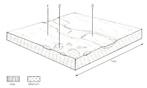 |
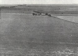 The western parts of the land system show very little dissection and form a flat plain between the Tertiary sediments in the south and the basalt in the north. | 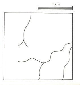 |
Area: 81 km2 | Component and its proportion of land system | ||
1 80% | 2 10% | 3 10% | |
| CLIMATE Rainfall, mm | Annual: 600 – 650, lowest January (30), highest February (75) | ||
Temperature, 0oC | Annual: 13, lowest July (8), highest February (19) | ||
Temperature: less than 10oC (av.) June - August | |||
Precipitation: less than potential evapotranspiration October – late April | |||
GEOLOGY Age, lithology | Pleistocene clay, silt and some sand | ||
TOPOGRAPHY Landscape | Flat plain bordering the present flood plain of the Barwon River | ||
Elevation, m | 110 – 130 | ||
Local relief, m | 10 | ||
Drainage pattern | Dendritic | ||
Drainage density, km/km2 | 0.8 | ||
Land form | Flat plain | ||
| Land form element | Flat plain | Sinkhole | Younger terrace |
Slope (and range), % | 1 (0-3) | 0 (0-1) | 2 (1-3) |
Slope shape | Linear | Concave | Linear |
NATIVE VEGETATION Structure | Woodland | Sedgeland | Woodland |
Dominant species | E. viminalis, E. ovata | Carex spp. Scirpus calocarpus, Schoenus apogon, Juncus spp. Ranunculus spp. | E. ovata, E. camaldulensis |
SOIL Parent material | Calcareous clay | Sedgeland | Woodland |
Description | Yellow-brown calcareous duplex soils, coarse structure | Grey calcareous sodic clay soils, uniform texture | Grey gradational soils |
Surface texture | Fine sandy loam | Clay | Clay loam |
Permeability | Very low | Very low | Very low |
Depth, m | >2 | >2 | >2 |
| LAND USE | Sheep and beef cattle grazing; dairy farming; cropping. | ||
| SOIL DETERIORATION HAZARD Critical land features, processes, forms | Dispersible clay subsoils of low permeability and prone to gully and tunnel erosion. Seasonally high water tables lead to soil salting. | High water tables and low permeability lead to waterlogging, soil compaction and soil salting. | High seasonal water table, low permeability and saline groundwater lead to waterlogging, soil compactions and soil salting. |