Victorian Resources Online (archived)
Ferguson Hill Land System
Download the pdf version of this document: Ferguson Hill Land System (PDF - 589 KB)
To view the information, PDF requires the use of a PDF reader. This can be installed for free from the Adobe website (external link).
| Most outcrops of Tertiary sediments to the west of the Otway Range are either deeply dissected or deeply weathered soils. However, some ridges and spurs are only mildly dissected and their soil profiles are only weakly developed. These areas are found at Ferguson Hill, just south of Simpson, along Pipeline Road and in an additional small area near Cape Otway. The parent material is Tertiary sand, silt and clay, with some minor areas of lateritic ironstone. The soils vary according to the nature of the outcropping beds, but in general their structure is weak and often the A and B horizons are not clearly differentiated. Profile drainage is good on all but those areas with hardpans, and these are the only areas prone to waterlogging despite the high annual rainfall. Eucalyptus obliqua and E. baxteri colonize most areas and often reach heights in excess of 30 m on the better-drained soils. However, these stands are decreasing in areas as much of the land is being cleared for agriculture. The soils are naturally quite stable and the major problems are likely to arise from nutrient decline. | 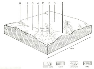 |
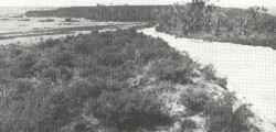 Along Pipeline Road the dissection is only mildly developed on these comparatively youthful soils. In the foreground E. nitida grown on grey sand soils, while in the distance tall open woodlands occur on red gradational soils with weak structures. | 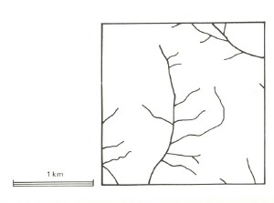 |
Area: 52 km2 | Component and its proportion of land system | |||||||
1 15% | 2 20% | 3 25% | 4 5% | 5 8% | 6 15% | 7 10% | 8 2% | |
| CLIMATE Rainfall, mm | Annual: 1,000 – 1,100, lowest January (40), highest August (130) | |||||||
| Temperature, 0oC | Annual: 13, lowest July (7.5), highest February (19) | |||||||
Temperature: less than 10oC (av.) June - August | ||||||||
Precipitation: less than potential evapotranspiration mid November – March | ||||||||
| GEOLOGY Age, lithology | Paleocene marine sand, clay and silt; some Pleistocene lateritic ironstone | |||||||
| TOPOGRAPHY Landscape | Undulating hills and ridges | |||||||
| Elevation, m | 30-230 | |||||||
| Local relief, m | 40 | |||||||
| Drainage pattern | Dendritic | |||||||
| Drainage density, km/km2 | 2.4 | |||||||
| Land form | Hill | Drainage line | Broad ridge | Scarp | ||||
| Land form element | Lower slope | Slope | Crest | Midslope | - | Crest, upper slope | Crest | - |
| Slope (and range), % | 4 (1-7) | 14 (5-37) | 5 (2-9) | 11 (3-15) | 4 (2-9) | 4 (0-11) | 4 (0-7) | 29 (25-37) |
| Slope shape | Straight | Straight | Convex | Straight | Concave | Convex | Straight | Concave |
| NATIVE VEGETATION Structure | Open forest | Open forest | Low woodland (variable) | Open forest | Open forest | Open forest | Tall woodland | Open forest |
| Dominant species | E. obliqua, E. ovata | E. baxteri, E. nitida, E. obliqua | E. nitida, E. baxteri | E. baxteri, E. radiata, E. obliqua, E. cypellocarpa | E. obliqua, E. baxteri | E. baxteri, E. obliqua | E. baxteri, E. obliqua | E. obliqua, E. baxteri, E. ovata, Acacia melanoxylon |
| SOIL Parent material | Clay and silt | Clay, silt and sand | Sand | Sand, silt and clay | Alluvial sand, silt and clay | Clay and silt; some lateritic remnants | Clay and silt; some lateritic remnants | Colluvial lateritic ironstone |
| Description | Grey-brown gradational soils | Yellow gradational soils, weak structure | Grey sand soils with hardpans, uniform texture | Red sandy loam soils uniform texture | Grey gradational soils | Mottled yellow and red gradational soils | Red gradational soils, weak structure | Stony red gradational soils |
| Surface texture | Fine sandy loam | Sandy loam | Loamy sand | Sandy loam | Sand loam | Sandy loam | Sandy loam | Gravelly loamy sand |
| Permeability | Moderate | High | Very low | Very high | Low | Moderate | High | Very high |
| Depth, m | >2 | >2 | >2 | >2 | >2 | >2 | 0.9 | >2 |
| LAND USE | Uncleared areas: Hardwood forestry for sawlogs, posts and poles; water supply; nature conservation; gravel extraction. Cleared areas: Sheep and beef cattle grazing; dairy farming; water supply | |||||||
| SOIL DETERIORATION HAZARD Critical land features, processes, forms | Minor hazards. | Weakly structured surfaces on steeper slopes are prone to sheet erosion. Low inherent fertility and high permeability lead to nutrient decline. | Weakly structured sands on hardpans are pone to sheet erosion and seasonal waterlogging. Permeable surface sands of high acidity and low inherent fertility are prone to nutrient decline. | Low inherent fertility and high permeability lead to nutrient decline. | High seasonal water table lead to soil compaction. | Low inherent fertility, phosphorus fixation and permeable surfaces lead to nutrient decline. | Low inherent fertility and high permeability lead to leaching of nutrients. | Steep slopes with weakly structured surface soils of low water holding capacity are prone to sheet erosion. |