Victorian Resources Online (archived)
Forrest Land System
Download the pdf version of this document: Forrest Land System (PDF - 713 KB)
To view the information, PDF requires the use of a PDF reader. This can be installed for free from the Adobe website (external link).
| From Upper Gellibrand to Peters Hill, steep spurs and ridges with long straight slopes and narrow valleys form the rugged northern margin of the Otway Range. The climate is significantly drier than in other parts of the Range, with most areas receiving an annual rainfall of about 900 mm. The inland extent of the land system marks the northern boundary of continuous Cretaceous outcrop, although sporadic outcrops occur in the adjacent Pennyroyal land system. The separation of these drier spurs and ridges from the rest of the Range is well reflected by changes in the structure and composition of the native vegetation. In particular, Eucalyptus radiata becomes a prominent member of the dominant stratum and the understorey changes from mesophytic species to drier sclerophyllous species such as Acacia mucronata, A. verticillata, Cassinia longifolia and Epacris impressa. Most of this land system remains forested and is selectively logged for millable timber. Some parts of the eastern areas have been cleared for grazing, but management is difficult due to rugged terrain. Softwood plantations have also been established. Landslips and sheet erosion have been severe in some areas, and rapid run-off from these hills creates problems of gully erosion in the Barwon River land system. | 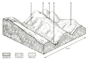 |
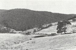 On the areas that have been cleared weeds such as blackberries and ragwort become a problem. | 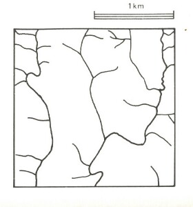 |
Area: 41 km2 | Component and its proportion of land system | ||||
1 10% | 2 50% | 3 4% | 4 35% | 5 1% | |
| CLIMATE Rainfall, mm | Annual: 900 – 1,100, lowest January (45), highest August (130) | ||||
Temperature, 0oC | Annual: 12, lowest July (7), highest February (17) | ||||
Temperature: less than 10oC (av.) June – September | |||||
Precipitation: less than potential evapotranspiration mid November – mid March | |||||
GEOLOGY Age, lithology | Lower Cretaceous feldspathic sandstone and mudstone | ||||
TOPOGRAPHY Landscape | Deeply dissected hills of the Otway Range | ||||
Elevation, m | 150 – 400 | ||||
Local relief, m | 150 | ||||
Drainage pattern | Dendritic | ||||
Drainage density, km/km2 | 3.8 | ||||
Land form | Hill | ||||
| Land form element | Steepest slope | North and west facing slopes | Crest, upper slope | South and east facing slopes | Lower slope, drainage line |
| Slope (and range), % | 60 (20-70) | 45 (25-65) | 20 (5-30) | 45 (25-65) | 20 (1-35) |
| Slope shape | Linear | Linear | Convex | Linear | Concave |
| NATIVE VEGETATION Structure | Woodland | Open forest | Open forest | Tall open forest | Tall open forest |
| Dominant species | E. radiata, E. cypellocarpa | E. obliqua, E. radiata, E. cypellocarpa | E. obliqua, E. radiata, E. cypellocarpa | E. cypellocarpa, E. obliqua | E. cypellocarpa, E. obliqua, E. ovata, Acacia melanoxylon |
| SOIL Parent material | Colluvium | In-site weathered rock | In-situ weathered rock | ||
| Description | Stony brown gradational soils | Brown duplex soils | Brown duplex soils | Brown gradational soils | Brown gradational soils, weak structure |
| Surface texture | Fine sandy loam | Loam | Loam | Loam | Silty loam |
| Permeability | Very high | Moderate | Moderate | High | Loam |
| Depth, m | 0.5 | 0.9 | 0.9 | 0.9 | >2 |
| LAND USE | Uncleared areas: Hardwood forestry for sawlogs, posts and poles; softwood forestry; nature conservation; active and passive recreation; water supply. Cleared areas: Beef cattle grazing on mainly unimproved pastures. | ||||
| SOIL DETERIORATION HAZARD Critical land features, processes, forms | Stony shallow soils with weak structure and low water holding capacity on steep slopes are prone to sheet erosion and landslips. | Dry aspect, steep slopes and weakly structured surfaces lead to sheet erosion. Clay subsoils on steep slopes subject to periodic saturation are prone to landslips. | Steeper slopes are prone to sheet erosion. | Steep slopes are prone to sheet erosion. Clay subsoils on steep slopes subject to periodic saturation are prone to landslips. | Weakly structured soils receiving run-off are prone to scour gullying, siltation and flooding. |