Victorian Resources Online (archived)
Gellibrand River Land System
Download the pdf version of this document: Gellibrand River Land System (PDF - 533 KB)
To view the information, PDF requires the use of a PDF reader. This can be installed for free from the Adobe website (external link).
| Many of the larger rivers in the wetter parts of the study area have extensive flood plains. Areas large enough to map exist on the Barham, Aire and Johanna Rivers as well as the Gellibrand River and its tributaries. The landscape is generally flat, but irregular areas occur in the form of infilled meanders and minor terraces. In general, most areas are poorly drained, with stunted vegetation. However, closer to the drainage lines, the improved drainage often results in conditions more favourable for plant growth. Most of these alluvial flats have been cleared and provide valuable summer grazing for dairy farms along the valleys. Areas prone to waterlogging have been drained and improved pastures established. However, the remoteness of the valleys, set among very infertile surrounding land, has hampered agricultural development. | 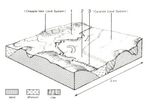 |
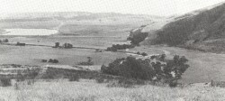 The Aire River has an extensive floodplain with many swamps and lakes where it emerges from the Otway Range near Hordern Vale. | 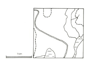 |
Area: 52 km2 | Component and its proportion of land system | ||
1 60% | 2 30% | 3 10% | |
| CLIMATE Rainfall, mm | Annual: 950 – 1,100, lowest January (45), highest August (135) | ||
| Temperature, 0oC | Annual: 13, lowest July (8), highest February (18) | ||
Temperature: less than 10oC (av.) June – September; July only near the coast | |||
Precipitation: less than potential evapotranspiration early November – late March; December – January near coast | |||
| GEOLOGY Age, lithology | Recent alluvium derived from the Otway Range and surrounding foothills. | ||
| TOPOGRAPHY Landscape | Alluvial flood plain of the Gellibrand, Aire and Barham Rivers | ||
| Elevation, m | 0 – 100 | ||
| Local relief, m | 3 | ||
| Drainage pattern | Major meandering stream with deranged tributaries | ||
| Drainage density, km/km2 | 1.3 | ||
| Land form | Alluvial terrace | Streambank, cut-off meander, lower terrace | |
| Land form element | Poorly drained lower reaches | Well-drained upper reaches | - |
| Slope (and range), % | 1 (0-2) | 0 (0-1) | 2 (0-5) |
| Slope shape | Linear | Linear | Convex |
| NATIVE VEGETATION Structure | Low woodland | Tall open forest | Tall open forest |
| Dominant species | E. obliqua, E. radiata, E. ovata | E. viminalis, E. obliqua, E. ovata, Acacia melanoxylon | E. viminalis, E. obliqua, Acacia melanoxylon |
| SOIL Parent material | Alluvial clay, silt and sand | Alluvial clay, silt and sand | Alluvial sand, silt and clay |
| Description | Grey gradational soils | Brown gradational soils, weak structure | Brown sandy loam soils, uniform texture |
| Surface texture | Fine sandy loam | Fine sandy loam | Sandy loam |
| Permeability | Very low | Moderate | Very high |
| Depth, m | >2 | >2 | >2 |
| LAND USE | Cleared areas: Dairy farming and beef cattle grazing on improved pastures; row and fodder cropping; water supply Uncleared areas: Water supply; nature conservation; hardwood forestry for sawlogs | ||
| SOIL DETERIORATION HAZARD Critical land features, processes, forms | High discharge rates along watercourses lead to flooding and siltation. High seasonal water table and low permeabilities lead to seasonal waterlogging and soil compaction. | High discharge rates along watercourses lead to flooding and siltation. Weakly structured soils are prone to surface compaction. | High discharge rates along watercourses with weakly structured soils lead to streambank erosion and siltation. High seasonal water table in some areas leads to waterlogging. |