Victorian Resources Online (archived)
Gherang Gherang Land System
Download the pdf version of this document: Gherang Gherang Land System (PDF - 562 KB)
To view the information, PDF requires the use of a PDF reader. This can be installed for free from the Adobe website (external link).
| Inland from Point Addis and extending west as far as Wormbete Creek, flat-topped hills represent the remnants of an extensive former lateritic plateau. Small remnants are also found further north towards Moriac. Over most of this landscape lateritic profiles are present, indicating former climatic conditions different from those experienced today. Where the Tertiary sediments contain excessive amounts of gravel, lateritic profiles are absent, but there is still evidence of deep weathering and leaching. The soils are generally infertile, carrying a vegetation of stunted woodlands of Eucalyptus obliqua and E. radiata. The cinnamon fungus, Phytophthora cinnamomi, is very common on these plateau remnants and large areas of dead and dying native vegetation can be found. Many of these remnants remain uncleared and are used for flora and fauna reserves and some minor forestry operations. Gravel extraction pits have been established on suitable areas of Crown land. These pits will not revegetate quickly without the appropriate management and have become popular with trail-bike-riders. | 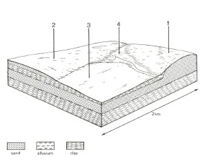 |
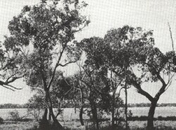 The flat lateritic plateaux carry woodland of E. obliqua and E. radiata, but the timber is generally unsuitable for milling. | 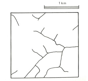 |
Area: 52 km2 | Component and its proportion of land system | |||
1 20% | 2 7% | 3 65% | 4 8% | |
| CLIMATE Rainfall, mm | Annual: 600 – 850, lowest January (35), highest August (80) | |||
| Temperature, 0oC | Annual: 14, lowest July (9), highest February (17) | |||
Temperature: less than 10oC (av.) July | ||||
Precipitation: less than potential evapotranspiration mid October - April | ||||
| GEOLOGY Age, lithology | Lateritized Tertiary clay, gravel and clayey silt | |||
Recent aeolian siliceous sand | ||||
| TOPOGRAPHY Landscape | Flat or gently dissected plateau remnants | |||
| Elevation, m | 50 - 230 | |||
| Local relief, m | 10 | |||
| Drainage pattern | Rectangular | |||
| Drainage density, km/km2 | 1.6 | |||
| Land form | Gently undulating plateau | |||
| Land form element | Crest, slope | Slope | Broad flat crest, slope | Swale, broad depression |
| Slope (and range), % | 2 (0-8) | 2 (0-3) | 2 (0-5) | 1 (0-3) |
| Slope shape | Convex | Irregular | Linear | Concave |
| NATIVE VEGETATION Structure | Woodland | Woodland | Open forest | Open forest |
| Dominant species | E. obliqua, E. radiata, E. ovata | E. radiata, E. nitida, E. obliqua | E. obliqua, E. baxteri, E. radiata, E. aromaphloia | E. ovata, E. viminalis |
| SOIL Parent material | Quartz gravel, sand, some clay | Siliceous sand | Lateritized sediments | Alluvial sand, clay, silt and plant remains |
| Description | Stony yellow gradational soils | Grey sand soils, uniform texture | Mottled yellow and red duplex soils with ironstone | Yellow-brown duplex soils, coarse structure |
| Surface texture | Gravelly loamy sand | Loamy sand | Loamy sand | Fine loamy sand |
| Permeability | Very high | Very high | Moderate | Very low |
| Depth, m | >2 | >2 | 1.2 | >2 |
| LAND USE | Uncleared areas: Hardwood forestry for posts, poles and firewood; nature conservation; passive and active recreation; gravel extraction. Cleared areas: Beef cattle grazing on unimproved pastures; residential | |||
| SOIL DETERIORATION HAZARD Critical land features, processes, forms | Low inherent fertility and high permeability lead to leaching of nutrients. | Low inherent fertility and high permeability lead to leaching of nutrients. Weakly structured sands with low water holding capacities are prone to wind erosion. | Low inherent fertility phosphate fixation and leaching of permeable upper horizons lead to nutrient decline. | High seasonal water table and weak surface structured lead to surface compaction. |