Victorian Resources Online (archived)
Pennyroyal Land System
Download the pdf version of this document: Penny Royal Land System (PDF - 441 )
To view the information, PDF requires the use of a PDF reader. This can be installed for free from the Adobe website (external link).
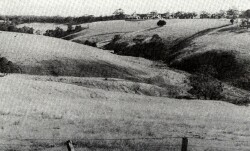
| Along the northern periphery of the Range, flat-topped spurs and ridges form an irregular band of foothills from Wormbete Creek to Barwon Downs. The terrain is variable, with steep slopes leading away from these gentle hill crests to wide valley floors. The ridge slopes upwards towards the Range and becomes narrower as the local relief increases. The gentle parts of the landscape are formed on Tertiary clay, silt and sand. These sediments overlie Cretaceous sandstones and mudstones, which outcrop on steep slopes on the valley sides. Soil and vegetation reflect changes in the parent material, with the soils on the upper parts of the landscape being somewhat deeply weathered with sandy surface horizons in contrast to loam or clay loam soils on the Cretaceous outcrops. Clearing has been widespread and sheep and beef cattle grazing as well as dairy farming are the main land uses. Some hardwood is logged from forested areas, and softwood plantations have been established in the east. Poor management of these hills can lead to rapid surface run-off along the valleys creating problems of gully erosion, siltation and flooding further downstream. | 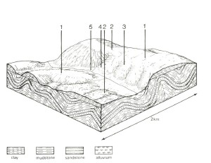 |
 Upper gentle slopes are formed on Tertiary clay, silt and sand, while Cretaceous sandstones and mudstones outcrop on steep slopes along the valley sides and Recent alluvium is found in the valley floor. | 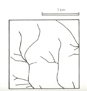 |
Area: 97 km2 | Component and its proportion of land system | ||||
1 35% | 2 15% | 3 35 | 4 12% | 5 3% | |
| CLIMATE Rainfall, mm | Annual: 700 – 1,050, lowest January (35), highest August (80) | ||||
| Temperature, 0oC | Annual: 12, lowest July (8), highest February (18) | ||||
Temperature: less than 10oC (av.) June – September | |||||
Precipitation: less than potential evapotranspiration November - March | |||||
| GEOLOGY Age, lithology | Tertiary unconsolidated clay, silt and sand. Minor remnants of lateritization | Lower Cretaceous sandstone and mudstone | Recent alluvial clay, silt and sand | ||
| TOPOGRAPHY Landscape | Steep rolling hills on the northern periphery of the Otway Range | ||||
| Elevation, m | 135 - 300 | ||||
| Local relief, m | 65 | ||||
| Drainage pattern | Dendritic | ||||
Drainage density, km/km2 | 1.9 | ||||
| Land form | Hill | Valley floor | |||
| Land form element | Gentle crest | Upper slope, crest | Gentle upper slope | Steep lower slope | - |
| Slope (and range), % | 3 (0-15) | 7 (0-25) | 15 (3-25) | 30 (5-45) | 1 (0-2) |
| Slope shape | Convex | Convex | Linear | Linear | Concave |
| NATIVE VEGETATION Structure | Open forest | Open forest | Open forest | Open forest | Tall open forest |
| Dominant species | E. obliqua, E. ovata, E. radiata, E. aromaphloia, E. nitida | E. obliqua, E. radiata, E. nitida, E. viminalis | E. obliqua, E. viminalis, E. radiata, E. ovata, Acacia melanoxylon | E. obliqua, E. radiata, E. cypellocarpa | E. obliqua, E. cypellocarpa, E. globulus |
| SOIL Parent material | Clay, silt and sand, often deeply weathered | Sand and clay | Clay, silt and sand | In-situ weathered rock | Alluvium |
| Description | Mottled yellow and red duplex soils | Yellow gradational soils, weak structure | Yellow-brown duplex soils, coarse structure | Brown duplex soils | Grey gradational soils |
| Surface texture | Sandy loam | Loamy sand | Fine sandy loam | Loam | Sandy loam |
| Permeability | Moderate | High | Low | Moderate | Low |
| Depth, m | >2 | >2 | >2 | 0.8 | >2 |
| LAND USE | Cleared areas: sheep and beef cattle grazing; dairy farming; water supply. Uncleared areas: Hardwood forestry for some sawlogs, posts and poles; softwood plantations; nature conservation; water supply; gravel extraction; passive recreation | ||||
| SOIL DETERIORATION HAZARD Critical land features, processes, forms | Low inherent fertility and phosphorus fixation lead to nutrient decline. Weakly structured surface soils on steeper slopes are prone to sheet erosion. | Low inherent fertility and high permeability lead to nutrient decline. Weakly structured soils on steepest slopes prone to sheet erosion. | Dispersible clay subsoils on steep slopes are prone to gully erosion. Soils of low permeability on steep slopes are prone to sheet erosion. | Steep slopes lead to sheet erosion, particularly on dry aspects. Clay subsoils on steep slopes subject to periodic saturation are pone to landslips. | High seasonal water table and low permeability lead to seasonal waterlogging, soil compaction and soil salting. High discharge rates, dispersible clay subsoils and dispersible sandy clay parent material of low mechanical strength lead to gully and tunnel erosion. |