Victorian Resources Online (archived)
Redwater Creek Land System
Download the pdf version of this document: Redwater Creek Land System (PDF - 423 )
To view the information, PDF requires the use of a PDF reader. This can be installed for free from the Adobe website (external link).
| In the southern parts of the Otway Range, gentle hill cappings of Tertiary quartzitic sands occur as remnants on the high parts of the landscape. Most creeks and rivers have dissected through these sands, exposing Cretaceous sandstone and mudstone on steep slopes leading down to the drainage lines. The capping of sand overlies Cretaceous sediments at a fairly shallow and uniform depth. The native vegetation on the sands is not dissimilar from that on the surrounding brown gradational soils, consisting of tall open forests of Eucalyptus obliqua, E. cypellocarpa and E. regnans on the better sites. These tall trees apparently extract nutrients from underlying weathering Cretaceous rocks. Nutrient cycling by leaf fall and decay has built up the fertility of the sands, far above that normally encountered on such parent material. Only minor parts of this land system have been cleared and it appears that a marked decline in soil fertility has resulted. Hardwood forestry is the main land use, together with a small industry in the cutting of tea-tree stakes. | 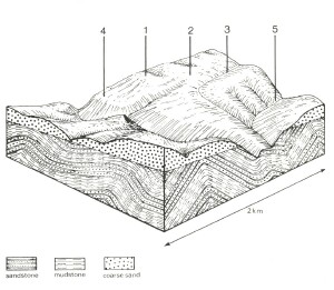 |
 The higher parts of the landscape form undulating hills, with E. regnans successfully competing with other trees on sand soils. | 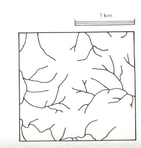 |
Area: 57 km2 | Component and its proportion of land system | ||||
1 5% | 2 40% | 3 5% | 4 25% | 5 25% | |
| CLIMATE Rainfall, mm | Annual: 1,150 – 1,60, lowest January (60), highest August (160) | ||||
| Temperature, 0oC | Annual: 12, lowest July (7), highest February (16) | ||||
Temperature: less than 10oC (av.) June – September | |||||
Precipitation: less than potential evapotranspiration December – mid February | |||||
| GEOLOGY Age, lithology | Paleocene unconsolidated quartz sand and gravel shallowly underlain by Lower Cretaceous sandstone and mudstone | Lower Cretaceous sandstone and mudstone | |||
| TOPOGRAPHY Landscape | Deeply dissected hills with broad gently hill cappings in the southern parts of the Otway Range. | ||||
| Elevation, m | 15 – 370 | ||||
| Local relief, m | 90 | ||||
| Drainage pattern | Dendritic with some radial areas | ||||
| Drainage density, km/km2 | 3.7 | ||||
| Land form | Rise | Scarp | |||
| Land form element | Crest | Crest, upper slope | Swale | Crest, upper slope | Steep slope |
Slope (and range), % | 4 (1-7) | 20 (3-35) | 3 (1-5) | 8 (3-15) | 35 (10-60) |
Slope shape | Linear | Convex | Concave | Irregular | Linear |
NATIVE VEGETATION Structure | Woodland | Tall open forest | Closed forest | Open forest | Tall open forest |
Dominant species | E. nitida, E. baxteri | E. obliqua, E. cypellocarpa, E. regnans, E. viminalis | Leptospermum juniperinum | E. regnans, E. obliqua, E. baxteri, occasionally E. viminalis | E. obliqua, E. regnans, E. cypellocarpa, E. viminalis |
SOIL Parent material | Deep deposits of quartz sand | Shallow deposits of quartz sand | Alluvial sand and gravel, organic matter | Shallow deposits of quartz sand and gravel | In-situ weathered rock |
Description | Grey sand soils with hardpans, uniform texture | Black sand soils, uniform texture | Black sand soils, uniform texture | White sand soils, uniform texture | Brown gradational soils |
Surface texture | Loamy sand | Sandy6 loam | Silty loam | (Gravelly) loamy sand | Sandy clay loam |
Permeability | Low | High | Moderate | Very high | Moderate |
Depth, m | 1.2 | >2 | >2 | >2 | 1.4 |
| LAND USE | Uncleared areas: Hardwood forestry for sawlogs and pulpwood; tea-tree stake harvesting; nature conservation; sand and gravel extraction. Minor cleared areas: Beef cattle grazing on unimproved pastures. | ||||
| SOIL DETERIORATION HAZARD Critical land features, processes, forms | Hardpans restrict vertical drainage, leading to seasonal waterlogging. Very low inherent fertility with some leaching of permeable highly acidic surfaces leads to nutrient decline. | Soils of high permeability in high-rainfall areas are prone to nutrient decline. Steeper slopes with compacted soils (tracks, clear-felled areas) are prone to sheet and rill erosion. | High water tables lead to waterlogging. Run-off from adjacent hills lead to flooding and siltation. | Soils of very low inherent fertility, low nutrient – holding capacity and high permeability in high-rainfall areas are prone to nutrient decline. | Clay subsoils on steeper slopes are subject to periodic saturation and are prone to landslips. Steeper slopes are prone to sheet erosion. |