Victorian Resources Online (archived)
Waarre Land System
Download the pdf version of this document: Waarre Land System (PDF - 364 KB)
To view the information, PDF requires the use of a PDF reader. This can be installed for free from the Adobe website (external link).
| Undulating plains to the north and west of Princetown are formed on Tertiary limestone, marl and calcareous clay. Only a small tract of this land lies within the study area, but the landscape is extensive in the neighbouring catchments of Scotts Creek and Cooriemungle Creek. Some faulting has led to occasional steep scarps, but most slopes are gentle and straight, separated by broad drainage lines. The gradational soils on these calcareous sediments are heavier-textured and significantly more fertile than soils formed on Tertiary sediments in adjacent land systems. Free lime is often present in the soil profile. Remnants of the native vegetation indicate that it was somewhat stunted, possibly as a result of the proximity of the coast. A large part of this land system lies within the Heytesbury Settlement Scheme and clearing has been widespread. Dairy farming is the main land use, although some of the earlier established areas close to the coast are used for sheep and beef cattle grazing. Subsoils are dispersible and gully erosion has occurred along some drainage lines. Landslip and slumping of road batters cause problems with road construction and access on the more undulating areas. Drainage lines remain waterlogged for most of the year and are prone to soil compaction by stock. | 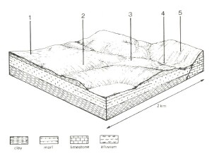 |
 Long straight slopes with broad drainage lines typify the landscape formed on these calcareous sediments, but occasional fault scarps are found close to the coast. | 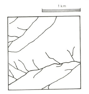 |
Area: 28 km2 | Component and its proportion of land system | ||||
1 4% | 2 65% | 3 20% | 4 8% | 5 3% | |
| CLIMATE Rainfall, mm | Annual: 900 – 1,000, lowest January (40), highest August (120) | ||||
| Temperature, 0oC | Annual: 14, lowest July (9), highest February (18) | ||||
Temperature: less than 10oC (av.) June – August | |||||
Precipitation: less than potential evapotranspiration November – March | |||||
| GEOLOGY Age, lithology | Miocene marine clay, marl and limestone in the lower reaches of the Gellibrand River catchment | ||||
| TOPOGRAPHY Landscape | Undulating plain with some fault scarps | ||||
| Elevation, m | 0 – 165 | ||||
| Local relief, m | 45 | ||||
| Drainage pattern | Dendritic | ||||
| Drainage density, km/km2 | 2.9 | ||||
| Land form | Rise | Drainage line | Fault scarp | ||
| Land form element | Upper slope, crest | Mid slope, crest | Lower slope | - | - |
| Slope (and range), % | 5 (2-9) | 11 (4-21) | 4 (1-7) | 0 (0-1) | 33 |
| Slope shape | Linear | Convex | Concave | Linear | Linear |
| NATIVE VEGETATION Structure | Open forest | Woodland | Woodland | Closed scrub | Woodland |
| Dominant species | E. obliqua, E. ovata, E. aromaphloia | E. ovata, E. radiata | E. obliqua, E. ovata | Melaleuca squarrosa, Leptospermum lanigerum | E. viminalis, Acacia melanoxylon |
| SOIL Parent material | Clay and sand | In-situ marl, limestone | Clay and sand | Plant remnants, alluvial sand and clay | In-situ marl and limestone |
| Description | Brown duplex soils, coarse structure | Brown calcareous gradational soils, coarse structure | Mottled yellow and grey gradational soils | Grey gradational soils | Black calcareous gradational soils |
| Surface texture | Fine sandy loam | Loam | Sandy loam | Silty loam | Clay |
| Permeability | Very low | Low | Moderate | Low | Moderate |
| Depth, m | >2 | 1.7 | >2 | >2 | >2 |
| LAND USE | Cleared areas: Grazing beef cattle; dairy cattle; sheep Minor uncleared areas: Nature conservation; includes the rugged coastline of the Port Campbell National Park | ||||
| SOIL DETERIORATION HAZARD Critical land features, processes, forms | Highly dispersible soils of low permeability are prone to gully and sheet erosion. Low inherent fertility and leaching of permeable surfaces lead to nutrient decline. | Clay subsoils on steeper slopes subject to periodic saturation are prone to landslips, slumping of road batters and gully erosion. | Dispersible subsoils are prone to gully erosion. | Dispersible subsoils of low permeability receiving run-off from surrounding hills are prone to gully erosion, waterlogging and soil compaction. | Clay soils on steep slopes subject to periodic saturation are prone to landslips and sheet erosion. |