Victorian Resources Online (archived)
Wonga Land System
Download the pdf version of this document: Wonga Land System (PDF - 365 KB)
To view the information, PDF requires the use of a PDF reader. This can be installed for free from the Adobe website (external link).
| Adjacent to the lateritic plateau around Simpson and at a similar elevation, a gently undulating plain without lateritic ironstone extends eastwards towards Barongarook. The parent material is mainly Tertiary sand and clay, with some minor redistribution on sand veneers in some parts and outcrops of deeply weathered Cretaceous sandstone along the sides of some of the drainage lines. The soils exhibit similar mottling and deep weathering to those found in the Simpson land system, and are prone to nutrient deficiencies and phosphate fixation. Open forests of Eucalyptus obliqua occur over most of the landscape, although E. baxteri tends to dominate on the polygenetic soils with hardpans. Acacia mucronata acts as a strong indicator of the presence of Cretaceous outcrops. Most areas remain uncleared and are selectively logged for hardwood timber, although most timber is of insufficient size to provide good sawlogs. | 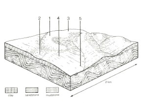 |
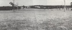 The cleared area in the foreground contrasts with the native hardwood forests. |  |
Area: 72 km2 | Component and its proportion of land system | ||||
1 45% | 2 7% | 3 25% | 4 15% | 5 8% | |
| CLIMATE Rainfall, mm | Annual: 850 – 950, lowest January (40), highest August (120) | ||||
| Temperature, 0oC | Annual: 13, lowest July (8), highest February (18) | ||||
Temperature: less than 10oC (av.) June – August | |||||
Precipitation: less than potential evapotranspiration late October – March | |||||
| GEOLOGY Age, lithology | Paleocene marine unconsolidated clay, silt and sand | Lower Cretaceous feldspathic sandstone and siltstone | |||
| TOPOGRAPHY Landscape | Undulating plain in the north part of the Gellibrand River catchment | ||||
| Elevation, m | 120 – 340 | ||||
| Local relief, m | 30 | ||||
| Drainage pattern | Parallel and dendritic | ||||
| Drainage density, km/km2 | 1.2 | ||||
| Land form | Undulating plain | ||||
| Land form element | Crest, upper slope | Colluvial fan, depression | Slope | Lower slope | Lower slope, drainage line |
Slope (and range), % | 7 (0-12) | 4 (0-7) | 7 (1-16) | 10 (4-14) | 10 (4-14) |
| Slope shape | Convex | Concave | Convex | Linear | Linear |
| NATIVE VEGETATION Structure | Open forest | Open woodland | Open forest | Open forest | Open forest |
| Dominant species | E. obliqua, E. radiata, E. baxteri, occasionally E. ovata, E. viminalis, E. aromaphloia | E. baxteri, E. ovata, E. nitida | E. baxteri, E. radiata, E. ovata, E. obliqua, occasionally E. aromaphloia | E. obliqua, E. radiata, E. ovata, E. baxteri | E. obliqua, E. ovata, E. radiata, E. aromaphloia |
| SOIL Parent material | Clay, silt and sand | Colluvial sand on sand, silt and clay | Colluvial sand on sand, silt and clay | Clay, silt and sand | In-situ weathered rock |
| Description | Mottled yellow and red gradational soils | Grey sand soils, weakly structured clay underlay | Grey sand soils, structured clay underlay | Yellow-brown gradational soils, coarse structure | Yellow-brown gradational soils, coarse structure |
| Surface texture | Sandy loam | Sandy loam | Sandy loam | Sandy loam | Fine sandy clay loam |
| Permeability | Moderate | Low | Low | Low | Low |
| Depth, m | >2 | >2 | >2 | >2 | 1.5 |
| LAND USE | Uncleared areas: Hardwood forestry for sawlogs, posts and poles; water supply; nature conservation; gravel extraction. Minor cleared areas: Beef cattle grazing; dairy farming | ||||
| SOIL DETERIORATION HAZARD Critical land features, processes, forms | Low inherent fertility and phosphorus fixation lead to nutrient decline. | Low permeability and perched water tables lead to seasonal waterlogging and soil compaction. | Low inherent fertility and leaching of permeable surfaces lead to nutrient decline. Low permeabilities lead to seasonal waterlogging and soil compaction. | Dispersible clay subsoils of low permeability are prone to gully erosion. Steeper slopes are prone to sheet erosion. | Dispersible subsoils receiving run-off from adjacent areas are prone to gully erosion. |