Victorian Resources Online (archived)
Yeodene Creek Land System
Download the pdf version of this document: Yeodene Land System (PDF - 829 KB)
To view the information, PDF requires the use of a PDF reader. This can be installed for free from the Adobe website (external link).
| West of Yeodene, a rolling and irregular landscape forms part of a broad ridge extending from the foothills of the Ranges towards Colac. Tertiary sand outcrops on most parts of the landscape, often forming a veneer over exposures of Tertiary silt and clay. The soils have loamy sand or sandy loam surface textures and are prone to nutrient and moisture deficiencies. Hardpans between the sand veneers and clay horizons may result in perched water tables, although only small areas have such poor site drainage that frequent waterlogging occurs. Sand and gravel have been extensively mined in some areas, and pine plantations have been established near Yeodene. However, most of the area remains in a fairly natural state and constitutes a significant area of natural vegetation close to Colac. Its potential for recreation is at present not fully utilized. Only minor areas have been cleared for agriculture, but the establishment of improved pastures is difficult. | 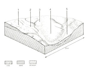 |
 Acid sands in this comparatively dry area will not support vigorous pastures and the control of weeds such as Pteridium esculentum and Rubus spp. is difficult. | 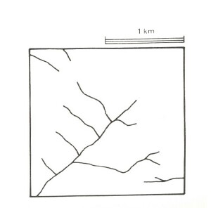 |
Area: 58 km2 | Component and its proportion of land system | ||||
1 35% | 2 25% | 3 5% | 4 30% | 5 5% | |
| CLIMATE Rainfall, mm | Annual: 750 – 850, lowest January (40), highest August (100) | ||||
| Temperature, 0oC | Annual: 13, lowest July (8), highest February (9) | ||||
Temperature: less than 10oC (av.) June – August | |||||
Precipitation: less than potential evapotranspiration late October – early April | |||||
| GEOLOGY Age, lithology | Paleocene unconsolidated sand, silt and clay Recent sand veneer | ||||
| TOPOGRAPHY Landscape | Rolling plain in the western parts of the Barwon catchment and northern parts of the Gellibrand catchment | ||||
| Elevation, m | 120 – 260 | ||||
| Local relief, m | 40 | ||||
| Drainage pattern | Dendritic | ||||
| Drainage density, km/km2 | 1.5 | ||||
| Land form | Plain | ||||
| Land form element | Crest, slope | Slope | Broad slightly depressed area | Crest, slope | Drainage line |
Slope (and range), % | 9 (1-15) | 15 (5-20) | 2 (0-5_ | 8 (1-15) | 3 (1-5) |
Slope shape | Convex | Irregular | Concave | Linear | Concave |
NATIVE VEGETATION Structure | Woodland | Woodland | Low woodland | Open forest | Low woodland |
Dominant species | E. viminalis, E. obliqua, E. radiata | E. radiata, E. ovata, E. viminalis, occasionally E. obliqua | E. nitida, E. radiata, occasionally E. viminalis | E. obliqua, E. radiata | E. ovata, Acacia melanoxylon, Leptospermum juniperinum, Melaleuca squarrosa |
SOIL Parent material | Quartz sand | Silt and clay with sand veneer | Silt and clay with sand veneer | Clay, silt and sand | Colluvial and alluvial sand, silt and clay, plant remains |
Description | Grey sand soils, uniform texture | Grey sand soils, weakly structured clay underlay | Grey sand soils, weakly structured clay underlay | Yellow gradational soils, weak structure | Black sand soils, uniform texture |
Surface texture | Loamy sand | Loamy sand | Loamy sand | Sandy loam | Silty loam |
Permeability | Very high | Low | Low | High | Moderate |
Depth, m | >2 | >2 | 0.6 | >2 | >2 |
| LAND USE | Uncleared areas: Hardwood forestry for posts, poles and fuel; sand and gravel extraction; forest grazing; water supply; passive and active recreation; softwood forestry. Minor cleared areas: Sheep and beef cattle grazing; dairy farming | ||||
| SOIL DETERIORATION HAZARD Critical land features, processes, forms | Very low inherent fertility and high permeability lead to nutrient decline. | Low inherent fertility and leaching of permeable surfaces lead to nutrient decline. Weakly structured surfaces and low permeabilities lead to sheet erosion on steeper slopes. | Low permeability and poor site drainage lead to seasonal waterlogging and soil compaction. | Weakly structured surfaces on steeper slopes are prone to sheet erosion. | High water tables lead to waterlogging and soil compaction. Run-off from adjacent hills leads to siltation and flooding. |