Victorian Resources Online (archived)
Mt Gellibrand Soil Pit Sites
Back to: Corangamite Soil
 Participants at Australian Society of Soil Science excursion to Mt Gellibrand. |
Soil pits were described in the Mt Gellibrand area for an Australian Society of Soil Science (ASSS) excursion held on November 6th 2004. The soil pits were selected to further characterise some of the main soils described by Leeper et al. (1936). The assistance and hospitality of Lachlan and Janet Gordon (owners of the 'Turkeith' property where the soil pits were excavated) is gratefully acknowledged. |
|
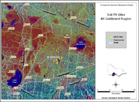
This map shows the location of the ASSS soil pits. It shows radiometric data superimposed on a Digital Terrain Model, which is part of an image prepared for Bernie Joyce (University of Melbourne) by David Moore, Senior Geophysicist, Geoscience Victoria (DPI). |