Victorian Resources Online (archived)
CLRA01
Location: Leopold
Australian Soil Classification: Melanic, Eutrophic, Grey DERMOSOL / Endocalcareous, Self-Mulching, Grey VERTOSOL
General Landscape Description: Stagnant alluvial plain.
Site Description: Flat.
Geology: Quaternary alluvium, colluvium, lagoon and swamp deposits: gravel, sand, silt.
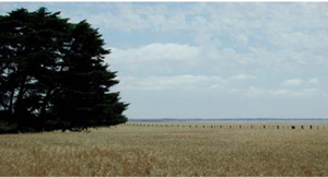
CLRA1 Landscape. Near level alluvial plain near Leopold.
Soil Profile Morphology:
Horizon | Depth (cm) | |||
A11 | 0–5 | Very dark grey (10YR3/1); sapric silty loam; weak medium sub-angular blocky, parting to strong fine polyhedral structure; roughfabric; very firm consistence dry; pH 6.0; smooth abrupt boundary to: | 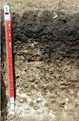 CLRA1 Profile | |
A12 | 5–30 | Black (10YR2/1); light medium clay; very few angular sandstone (2–20 mm) coarse fragments; strong fine polyhedral structure; rough fabric; strong consistence dry; pH 6.5; smooth clear boundary to: | ||
A3 | 30–45 | Dark grey (10YR4/1) with common medium distinct brown (10YR5/3) mottles; silty medium heavy clay; weak medium prismatic, parting to strong fine polyhedral structure; smooth fabric; strong consistence dry; pH 6.5; smooth clear boundary to: | ||
B21 | 45–80 | Light yellowish brown (2.5Y6/3) with very few large distinct red and yellow mottles; silty heavy clay; strong medium prismatic, parting to strong medium angular blocky structure; smooth fabric; few distinct clay skins and other cutans; very strong consistence dry; common calcareous soft segregations (6–20 mm); pH 8.5; wavy gradual boundary to: | ||
B22 | 80–130+ | Light yellowish brown (2.5Y6/3); many moderate faint yellow (10YR6/6) mottles; silty heavy clay; strong medium prismatic, parting to strong medium angular blocky structure; smooth fabric; few distinct clay skin and other cutans; strong consistence dry; common calcareous soft segregations (6–60 mm); pH 9.0. | ||
Soil Profile Characteristics:
Horizon | Sample Depth (cm) | pH (water) | pH (CaCl2) | EC 1:5 | NaCl % | Exchangeable Cations | |||
Ca | Mg | K | Na | ||||||
meq/100g | |||||||||
A11 | 0–5 | 6.2 | 5.9 | 0.37 | 0.02 | 29 | 5.1 | 2.9 | 0.3 |
A12 | 5–30 | 7.1 | 6.7 | 0.21 | - | 25 | 4.7 | 3.2 | 0.58 |
A3 | 30–45 | 8 | 7.5 | 0.36 | 0.02 | 27 | 6.8 | 2.5 | 1.2 |
B21 | 45–80 | 8.2 | 7.8 | 0.63 | 0.05 | 20 | 9.2 | 1.3 | 1.3 |
B22 | 80–130 | 8.2 | 7.9 | 0.77 | 0.08 | 17 | 13 | 1.5 | 1.9 |
Horizon | Sample Depth (cm) | Exchangeable Aluminium mg/kg | Exchangeable Acidity cmolc/kg | Field Capacity pF2.5 | Wilting Point pF4.2 | Coarse Sand (0.2- 2.0 mm) | Fine Sand (0.02- 0.2 mm) | Silt (0.002- 0.02 mm) | Clay (<0.002 mm) |
A11 | 0–5 | 17 | 11 | 48.9 | 37.9 | 10 | 24 | 17 | 32 |
A12 | 5–30 | 17 | 5.2 | 41.9 | 24.5 | 4.3 | 24.6 | 14.5 | 49.5 |
A3 | 30–45 | 59.0 | 31.9 | 1.8 | 11.8 | 7 | 73 | ||
B21 | 45–80 | 50.1 | 27.0 | 2.8 | 10.9 | 6.5 | 65.5 | ||
B22 | 80–130 | 49.4 | 26.4 | 2.9 | 11.6 | 7.5 | 65 |
Management Considerations:
- Clay soils are generally impermeable when saturated and require similar attention to the cracking soils; moisture status is important. Incorporation of organic matter may help structure and provide micro environments for roots.
- Friable surface soils (and subsoils) occur where there is a build up of organic matter [OC: A11; 9.4%, A12; 2.7%], (and to some extent iron rich clay complexes) generally in cooler wetter areas (less extreme wetting and drying cycling).
- Alkaline subsoils are associated with a high nutrient load but produce an imbalance in nutrient availability and do not suit some plant species (eg. potatoes). These soils are often associated with sodic and calcic soil materials. The high organic carbon levels of the upper soil and the high calcium levels are responsible for a stable soil [Emerson class 7 for the upper soil and Emerson class 5 for the subsoil] at this site.
- Calcium carbonate nodules (segregations; soft and hard) are associated with alkaline soils, usually as secondary lime found in the deep subsoil in many basalt derived soils. In this case much of the carbonate is of marine or estuarine origin (shells).
Profile Described By: David Rees (December 2002).
Source: Robinson et al (2003) A land resource assessment of the Corangamite region. Department of Primary Industries, Centre for Land Protection Research Report No. 19