Victorian Resources Online (archived)
CLRA04
Location: Murradoc, St Leonards district, Bellarine Peninsula
Australian Soil Classification: Eutrophic, Mottled-Hypernatric, Brown SODOSOL
General Landscape Description: Flat plain.
Geology: Quaternary alluvium, colluvium, lagoon and swamp deposits: gravel, sand, silt
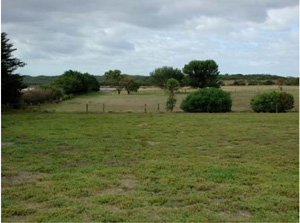
CLRA4 Landscape. Near level alluvial plains near St Leonards.
Soil Profile Morphology:
Surface Soil
| A1 | 0–15 cm | Dark grey (10YR4/1); fine sandy loam; weak medium sub-angular blocky structure; rough fabric; weak consistence dry; pH 5.5; wavy clear boundary to: | 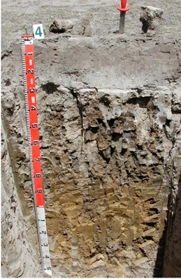 CLRA4 Profile. CLRA4 Profile. | |||
| A2 | 15–30 cm | Light brownish grey (10YR6/2), conspicuous bleach (10YR8/1 dry); heavy fine sandy loam; apedal massive structure; earthy fabric; very firm consistence dry; pH 6.0; smooth abrupt boundary to: | ||||
| Subsoil | ||||||
| B21 | 30–80 cm | Brown (10YR5/3) with many medium distinct orange grey and red (10YR5/6, 10YR4/1, 2.5YR5/6) mottles; light medium clay; strong coarse columnar, parting to strong medium angular blocky structure; smooth fabric; common prominent clay skin and other cutans; very strong consistence dry; few (6–60 mm) ferruginous soft concretions; pH 7.0; wavy gradual boundary to: | ||||
| B22 | 80–120 cm | Yellowish brown (2.5Y5/4); light medium clay; weak coarse columnar parting to medium and strong medium prismatic structure; smooth fabric; few distinct clay skin cutans; strong consistence dry; pH 8.5; wavy gradual boundary to: | ||||
| B23/B3 | 120–145+ cm | Light yellowish brown (2.5Y6/4) with few large yellow faint mottles; medium clay; weak coarse columnar, parting to medium and strong medium prismatic structure; smooth fabric; very few faint clay skin cutans; strong consistence dry; pH 8.5. | ||||
Soil Profile Characteristics:
Horizon | Sample Depth (cm) | pH (water) | pH (CaCl2) | EC 1:5 | NaCl % | Exchangeable Cations | |||
Ca | Mg | K | Na | ||||||
meq/100g | |||||||||
A1 | 0–15 | 5.2 | 4.6 | 0.12 | 2.7 | 1.2 | 0.57 | 0.51 | |
A2 | 15–30 | 5.7 | 5.1 | <0.05 | 0.58 | 0.31 | 0.1 | 0.16 | |
B21 | 30–80 | 7.4 | 6.4 | 0.29 | 0.04 | 3.7 | 10 | 0.3 | 4.9 |
B22 | 80–120 | 8.1 | 7.1 | 0.41 | 0.06 | 2.3 | 8.1 | 0.3 | 5.1 |
B23/B3 | 120–145+ | 8.1 | 7.2 | 0.61 | 0.11 | 3.4 | 12 | 0.4 | 8 |
Horizon | Sample Depth (cm) | Exchangeable Aluminium mg/kg | Exchangeable Acidity cmolc/kg | Field Capacity pF2.5 | Wilting Point pF4.2 | Coarse Sand (0.2- 2.0 mm) | Fine Sand (0.02- 0.2 mm) | Silt (0.002- 0.02 mm) | Clay (<0.002 mm) |
A1 | 0–15 | 12 | 9.1 | 23.4 | 5.9 | 10.6 | 62.4 | 14 | 7 |
A2 | 15–30 | <10 | 2 | 15.2 | 1.5 | 11.6 | 68.2 | 19 | 2.5 |
B21 | 30–80 | 37.3 | 17.2 | 7.4 | 46.4 | 8 | 34.5 | ||
B22 | 80–120 | 33.1 | 15.0 | 6.2 | 49.9 | 10 | 30.5 | ||
B23/B3 | 120–145+ | 43.3 | 27.8 |
Management Considerations:
- This soil has a strong texture contrast between the surface soil and the subsoil as well as sodic subsoils.
- It is important to maintain or improve the upper soil by increasing organic matter (particularly in the subsurface soil). The organic carbon content of the surface is 2% and the subsurface is 0.36%.
- Maintenance of a vegetative cover is important for soil stability particularly where the surface soil is light and susceptible to water and wind erosion.
- Root penetration of the subsoil may be difficult with the hardsetting nature of the soil, coarse structure and nutrient imbalance (alkalinity with high sodicity and some salinity).
- It would be advisable not to bring the very dispersive subsoil [Emerson class1] to the surface as it would promote surface sealing (hardsetting) as well as adverse nutrient affects.
Profile Described By: David Rees (December 2002).
Source: Robinson et al (2003) A land resource assessment of the Corangamite region. Department of Primary Industries, Centre for Land Protection Research Report No. 19