Victorian Resources Online (archived)
CLRA07
Location: Drysdale district, Bellarine Peninsula
Australian Soil Classification: Melacic, Sesquic, Aeric, PODOSOL
General Landscape Description: Crest of Dunes unit.
Geology: Quaternary Aeolian: coastal and inland dunes: dune sand, some swamp deposits
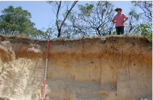
CLRA7 Landscape. Cutting in side of dune at Curlewis Golf Club
Soil Profile Morphology:
Surface Soil
A11 | 0–10 cm | Very dark grey (10YR3/1); loamy sand; weak medium sub-angular blocky structure; rough fabric; very weak consistence dry; pH 4.5; smooth clear boundary to: | 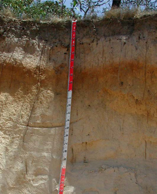 CLRA7 Profile | |||
A12 | 10–20 cm | Very dark grey (10YR3/1); light loamy sand; apedal single grain structure; sandy fabric; very weak consistence dry; pH 4.5; smooth gradual boundary to: | ||||
A2 | 20–50 cm | Light yellowish brown (10YR6/3), conspicuous bleach (10YR7/2); sand; apedal single grain structure; sandy fabric; very weak consistence dry; pH 5.0; wavy clear boundary to: | ||||
Subsoil | ||||||
Bhs | 50–90 cm | Brown (7.5YR4/3); heavy sand; apedal massive structure; sandy fabric; very weak consistence dry; pH 6.0; wavy diffuse boundary to: | ||||
C1 | 90–140 cm | Yellowish brown (10YR5/4); sand; apedal single grain structure; sandy fabric; very weak consistence dry; few argillaceous laminae; pH 6.0; wavy diffuse boundary to: | ||||
C2 | 140–195 cm | Very pale brown (10YR7/4); sand; apedal massive structure; sandy fabric; weak consistence dry; few argillaceous laminae; pH 7.0; wavy diffuse boundary to: | ||||
C3 | 195–210+ cm | Brownish yellow (10YR6/8); sand; apedal massive structure; sandy fabric; strong consistence dry; pH 6.5. | ||||
Soil Profile Characteristics:
Horizon | Sample Depth (cm) | pH (water) | pH (CaCl2) | EC 1:5 | Exchangeable Cations | |||
Ca | Mg | K | Na | |||||
meq/100g | ||||||||
A11 | 0–10 | 4.8 | 3.9 | 0.09 | 1.9 | 1.4 | 0.21 | 0.25 |
A12 | 10–20 | 4.6 | 3.8 | 0.05 | 0.8 | 0.5 | 0.1 | 0.13 |
A2 | 20–50 | 4.6 | 4 | <0.05 | 0.38 | 0.26 | 0.05 | 0.08 |
Bhs | 50–90 | 5.4 | 4.6 | <0.05 | 0.49 | 0.43 | 0.1 | 0.09 |
C1 | 90–140 | 5.9 | 5.2 | <0.05 | 0.22 | 0.42 | <0.05 | 0.08 |
C2 | 140–195 | 5.9 | 5.1 | <0.05 | - | - | - | - |
C3 | 195+ | 6.3 | 5.2 | 0.13 | 0.47 | 2.1 | 0.13 | 0.95 |
Horizon | Sample Depth (cm) | Organic Carbon % | Exchangeable Aluminium mg/kg | Exchangeable Acidity cmolc/kg | Field Capacity pF2.5 | Wilting Point pF4.2 | Coarse Sand (0.2- 2.0 mm) | Fine Sand (0.02- 0.2 mm) | Silt (0.002- 0.02 mm) | Clay (<0.002 mm) |
A11 | 0–10 | 5.5 | 16 | 10 | 12.3 | 12.7 | 16.6 | 74.9 | 1 | 3 |
A12 | 10–20 | 2.9 | 28 | 6.2 | 8.1 | 3.5 | 14.8 | 71 | 4.5 | 8.5 |
A2 | 20–50 | 23 | 2.4 | 9.2 | 1.6 | 16.6 | 71.3 | 6.5 | 4 | |
Bhs | 50–90 | 32 | 2.9 | 9.7 | 1.8 | 13.1 | 83.2 | 0.5 | 4 | |
C1 | 90–140 | <10 | - | 7.3 | 0.8 | 13.5 | 82.6 | 0.5 | 1.5 | |
C2 | 140–195 | - | 5.9 | 0.5 | 30.4 | 66.2 | 0 | 2 | ||
C3 | 195+ | 1 | 7.2 | 2.8 | 34.1 | 55.1 | 0.5 | 9.5 |
Management Considerations:
- This soil has a strong consistence contrast between the loose/weakly coherent deep sandy soil and the coherent subsoil which is sodic.
- It is important to maintain or improve the upper soil by increasing organic matter (particularly in the subsurface soil). The organic carbon content of the upper surface (A11) is 5.5% and the surface (A12) is 2.9%. This surface organic layer is important for soil stability as is the maintenance of a vegetative cover is important particularly where the surface soil is light and susceptible to water and wind erosion and variable slope (dunefield in this case).
- Root penetration of the “coffee rock” at depth may be difficult with the hardsetting nature of the layer, but the sandy soil above provides a suitable physical medium for growth though with little water and nutrient holding capacity.
Profile Described By: David Rees (December 2002).