Victorian Resources Online (archived)
SW64
|
| SW64 | 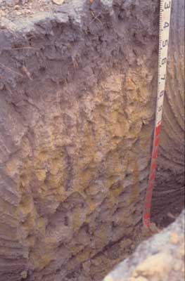 Humose–Acidic, Kandosolic, Redoxic HYDROSOL | |
| Simpson; north of Tomahawk Creek Road | |||
| Gently undulating plain | |||
| Neogene Hanson Plain Sand Formation | |||
| Gentle slope | |||
| 1% | |||
| South | |||
Horizon | Depth (cm) | Description | ||
A11 | 0–40/45 | Black (2.5Y2.5/1), grey (2.5Y6/1 dry) to light yellowish brown (2.5Y6/4 dry); light fine sandy loam; weakly pedal, very weak consistence; moderate amount of roots present; pH 5.1; clear boundary to: | ||
A12 | 45–55/60 | Greyish brown (2.5Y5/2 moist and dry); loamy sand; apedal; firm consistence; diffuse boundary to: | ||
B21g | 55/60–120 | Yellowish brown (10YR5/8) and light yellowish brown (2.5Y6/3) mottled; clayey sand; apedal; firm consistence; pH 4.8; gradual boundary to: | ||
B22g | 120 + | Light brownish grey (10YR6/2) with very coarse prominent yellowish brown (10YR5/6 and 5/8) mottles; clayey sand; apedal. | ||
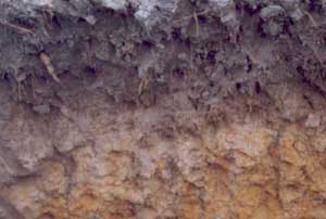
| Management considerations | ||||
| Acidity of the profile and waterlogging are the major limitations. The high organic carbon content of the topsoil (7.7%) and overall topsoil depth are compensating factors. | ||||
Analytical data
Site SW64 | Sample depth | pH | EC | NaCl | Ex Ca | Ex Mg | Ex K | Ex Na | Ex Al | Ex acidity | FC (-10kPa) | PWP (-150kPa) | KS | FS | Z | C | |
Horizon | cm | H2O | CaCl2 | dS/m | % | cmolc/kg | cmolc/kg | cmolc/kg | cmolc/kg | mg/kg | cmolc/kg | % | % | % | % | % | % |
| A1 | 0–40 | 5.1 | 4.5 | 0.26 | N/R | 2.3 | 0.5 | 0.5 | 0.3 | 17 | 16 | N/R | N/R | 37 | 38.4 | 10 | 4.5 |
| B21g | 55–120 | 4.8 | 4.2 | 0.06 | N/R | 0.09 | 0.54 | <0.05 | 0.18 | 150 | 5.7 | N/R | N/R | 27.7 | 41.6 | 11.5 | 20.5 |