Victorian Resources Online (archived)
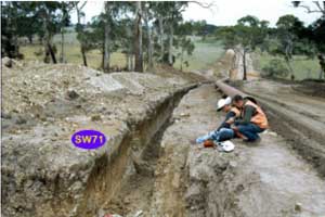
SW71
|
| SW71 | 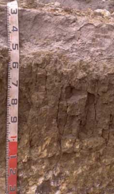 Bleached-Vertic (and mottled), Magnesic, Brown CHROMOSOL | |
| Foothills south of Colac; between Irrewillipie road and Colac-Lavers Hill road | |||
| Undulating low hills | |||
| Cretaceous Otway Group: volcanogenic sandstone | |||
| Waxing upper slope | |||
| 8% | |||
| West | |||
Horizon | Depth (cm) | Description | ||
A1 | 0–20 | Dark grey (10YR4/1 moist), greyish brown (10YR5/2 dry), fine sandy loam; moderately pedal; weak to firm consistence; pH 5.5; boundary to: | ||
A2e | 20–50/60 | Light brownish grey (2.5Y6/2 moist), conspicuously bleached (2.5Y8/1 dry); fine sandy loam; hardsetting; common (<20%) fine ferromanganiferous gravel (mostly not magnetic) sporadic and not in thick layer; very firm consistence; clear to gradual change (incipent B1) to; pH 5.8; boundary to: | ||
B21ss | 50/60–100/120 | Dark yellowish brown (10YR3/4 moist and dry); many (~25%), faint, fine to coarse (5-20 mm) yellow brown/dark red mottles; heavy clay; coarse (50-120 mm) prismatic, parting to thick lenticular or angular blocky structure; slickensides; pH 6.0;diffuse yellower; boundary to: | ||
C/B | 100/120+ | Brownish yellow (10YR6/8 moist) to yellow (10YR8/8 dry); fine sandy with white (10YR8/1 moist) and very dark grey (5YR3/1 moist) ped faces; below 150 cm extremely hard to break with geopick; cemented ferruginised sandstone. | ||
| Management considerations | ||||
| Fine sandy loam topsoil overlying this swelling clay (80% clay in the subsoil) renders this profile subject to waterlogging. Water erosion is also a hazard for this soil. Chemical fertility is low and the soil is acidic – Aluminium toxicity to plant growth is likely to reduce pasture yields unless lime is applied. | ||||
Analytical data
Site SW71 | Sample depth | pH | EC | NaCl | Ex Ca | Ex Mg | Ex K | Ex Na | Ex Al | Ex acidity | FC (-10kPa) | PWP (-150kPa) | KS | FS | Z | C | |
Horizon | cm | H2O | CaCl2 | dS/m | % | cmolc/kg | cmolc/kg | cmolc/kg | cmolc/kg | mg/kg | cmolc/kg | % | % | % | % | % | % |
A1 | 0–10 | 5.5 | 4.7 | 0.12 | N/R | 3.2 | 2.1 | 0.23 | 0.35 | 23 | 14 | 33.5 | 11.4 | 9.5 | 38 | 26.5 | 18 |
A2 | 30–50 | 5.8 | 4.7 | <0.05 | N/R | 0.67 | 0.96 | <0.05 | 0.17 | 23 | 6.2 | 19.1 | 6.8 | 7.8 | 44.5 | 24 | 23.5 |
B21 | 65–85 | 6 | 4.9 | 0.1 | N/R | 1.2 | 12 | 0.15 | 1.4 | 19 | 13 | 43 | 27 | 1.4 | 11.4 | 7 | 79.5 |