Victorian Resources Online (archived)
Soil/Landform Unit 168
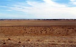 The broad hills crests and plains of the dissected plain has resulted in development for hills. Land is mainly used for cropping and grazing |
0.28% of CMA region The undulating low hills in the Maude and Moriac areas comprise predominantly Neogene unconsolidated sediments with woodland vegetation. These deeply weathered soils of the undulating low hills form part of the Western Plains. Soils are mainly brown texture contrast soils with occasional deep uniform sands. Surface soil horizons are naturally low in plant available nutrients and also have low water holding capacities. Most areas are cleared and support open woodlands (Plains Grassy Woodland and Grassy Woodland) dominated by Eucalyptus leucoxylon and E. camaldulensis. Other areas have been cleared for agricultural purposes including grazing and cropping. The main hazards to land use are leaching of nutrients and gully erosion. |  |
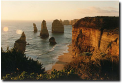
 The scarps and steep slopes that occur on the western boundary of the unit are composed of a source of geologies |  |
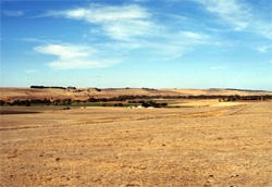
 | 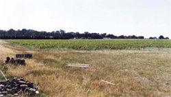 Potato crop at the base of Mount Duneed within this unit |
Component | 1 | 2 | 3 | 4 | 5 | 6 | 7 | 8 |
Proportion of soil-landform unit | 50% | 8% | 8% | 4% | 5% | 14% | 3% | 8% |
| CLIMATE Rainfall (mm) | Annual: 590 | |||||||
| Temperature (oC) | Minimum 9, Maximum 19 | |||||||
| Precipitation less than potential evapotranspiration | October-April | |||||||
| GEOLOGY Age and lithology | Neogene unconsolidated sediments | Quaternary basalt | Neogene unconsolidated sediments - gravel, sand and clay | Various Neogene Paleogene strata basalt, unconsolidated sediemnts (limestone, etc) | Ordovician slates and sandstones interbedded | Pleistocene basalt | ||
| Geomorphology | ||||||||
| LANDUSE | Uncleared: Nature conservation; water supply Cleared: Cropping; beef and cattle grazing; low quality forestry; gravel extraction; town sites | |||||||
| TOPOGRAPHY Landscape | Undulating low hills | |||||||
| Elevation range (m) | 8-193 | |||||||
| Local relief (m) | 12 | |||||||
| Drainage pattern | Dendritic | |||||||
| Drainage density (km/km2) | 0.7 | |||||||
| Landform | Undulating plains | Scarp | Sides of the river valley | Sides of the river valley | Sides of the river valley | Long gentle slopes with stony rises | ||
| Landform element | Upper plain | Drainage line | Lower plain | Stony upper slope or crest | Upper slope or crest | Mid-slope | Lower slope | Slopes |
| Slope and range (%) | 3 (2-5) | 1 (1-2) | 2 (1-5) | 45 (20-60) | 25 (10-50) | 20 (10-50) | 20 (10-50) | 2 (1-3) |
| Slope shape | Straight | Concave | Straight | Convex to straight | Convex | Straight to concave | Straight to concave | Straight |
| NATIVE VEGETATION Structure | Plains Grassy Woodland (0.9%) | Grassy Woodland (0.7%) | ||||||
| Dominant species | E. camaldulensis | E. camaldulensis | E. leucoxylon, Acacia spp. | E. leucoxylon, E. camaldulensis | E. leucoxylon, E. camaldulensis | E. leucoxylon, E. camaldulensis | E. leuxocylon, E. melliodora, E. viminalis | E. leucoxylon |
| SOIL Parent material | Unconsolidated clay, silt, sand and gravel | Unconsolidated sediments and recent alluvial deposits | Unconsolidated clay, silt, sand and gravel | In situ weathered basalt | In situ unconsolidated sediments with some areas of colluvial basalt | In situ unconsolidated sediments and limestone, with colluvium from higher land. Some quartzite outcrops | In situ slates and sandstone with colluvium | In situ weathered rock |
| Description (Corangamite Soil Group) | ||||||||
| Soil type sites | ||||||||
| Surface texture | Fine sandy loam | Sandy loam | Sandy loam | Clay loam | Clay to clay loam | Mostly clay with some sandy areas | Fine sandy clay loam | Sandy loam |
| Permeability | Moderate | Moderate to low | Low | Moderate | Moderate to low | Moderate | Moderate to low | Moderate to low |
| Depth (m) | 1.0-2.0 | 1.5-2.5 | 2 | 0.1-0.5 | 0.5-1.2 | 0.3-2.0 | 0.3-1.0 | 1.0-3.0 |
| LAND CHARACTERISTICS, POTENTIAL AND LIMITATIONS | Hardsetting surface can cause overland flow and minor sheet erosion. | Seasonal high watertables along with periodic waterlogging and minor gully erosion are the main erosion issues. | Dispersible subsoils and overland flow/subsurface flow conribute to moderate gully erosion. | Steep slopes, undercutting, slumping and falling rocks are minor hazards. | Moderate to steep slopes with deep black clayey soils, are known to be of moderate slip hazard. Rilling on exposed soils also occurs. | Moderate to steep slopes with deep black clayey soils, are known to be of moderate slip hazard. Rilling on exposed soils also occurs. | Moderate to steep slopes with deep black clayey soils, are known to be of moderate slip hazard. Rilling on exposed soils also occurs | Hardsetting surfaces and slowly permeable subsoils contribute to overland flow. Periodic waterlogging and soil compaction is an issue. |