Victorian Resources Online (archived)
Soil/Landform Unit 2
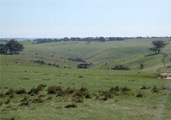
 Scarps and steep slopes are very typical within this landscape |
3.53 % of CMA region | 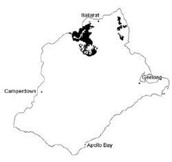 |
|
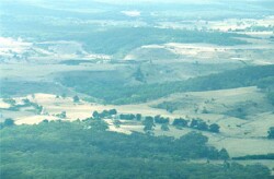
 Upper slopes leading to deeply dissected valleys and drainage depressions | 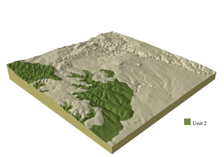 |
 | 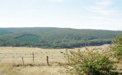 Plantation of Pinus radiata within a native vegetation stand at Garibaldi |
Component | 1 | 2 | 3 | 4 | 5 | 6 |
Proportion of soil-landform unit | 20% | 15% | 35% | 23% | 2% | 5% |
| CLIMATE Rainfall (mm) | Annual: 710 | |||||
| Temperature (oC) | Minimum 7, Maximum 18 | |||||
| Precipitation less than potential evapotranspiration | October-March | |||||
| GEOLOGY Age and lithology | Cambro-Ordovician marine sandstone and shale, minor Quaternary basalt and Neogene clay, sand and gravel. | |||||
| Geomorphology | ||||||
| LANDUSE | Uncleared: Nature conservation; sport and recreation; residential development, softwood plantations. Cleared: Softwood plantation; residential developement; sheep and beef cattle grazing | |||||
| TOPOGRAPHY Landscape | Rolling low hills and ridges | |||||
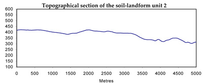
| Elevation range (m) | 180-670 | |||||
| Local relief (m) | 100 | |||||
| Drainage pattern | Dendritic | |||||
| Drainage density (km/km2) | 3.1 | |||||
| Landform | Hills | Drainage line | Ridges | |||
| Landform element | Broad crests | Gentle plains and rises | Rolling hills | Moderately steep slopes | Drainage line | Ridge/ravine |
| Slope and range (%) | 4(1-7) | 4(2-7) | 5(2-9) | 11(3-15) | 4(2-9) | 25(0-50) |
| Slope shape | Convex | Convex | Convex | Straight | Concave | Convex |
| NATIVE VEGETATION Ecological Vegetation Class | Heathy Dry Forest (36.5%); Grassy Dry Forest (5.2%); Herb-rich Foothill Forest (2.6%); Valley Grassy Forest (2.5%); Creekline Herb-rich Woodland (1.2%); Plains Grassy Woodland (1.2%) | |||||
| SOIL Parent material | In situ weathered sandstone and shale | In situ weathered sandstone and shale | In situ weathered sandstone and shale | In situ weathered sandstone and shale | Alluvium colluvium clay, silt, sand and gravel | In situ weathered sandstone and shale |
| Description (Corangamite Soil Group) | Acid and neutral mottled brown, grey or yellow texture contrast soils and shallow light texture soils (25) | Shallow light textured soils and acid and neutral mottled brown, grey or yellow texture contrast soils (25) | ||||
| Soil type sites | ||||||
| Surface texture | Gravelly loam | Fine sandy loam to clay loam | Fine sandy loam to clay loam | Gravelly loam | Clay loam | Gravelly loam |
| Permeability | High | Moderate | Moderate | High | Moderate | High |
| Depth (m) | <0.1 | <2 | <1.5 | <1.5 | 2 | <0.7 |
| LAND CHARACTERISTICS, POTENTIAL AND LIMITATIONS | Gentle slopes with low permeability leads to overland flow. This flow often creates sheet and rill erosion with major rainfall events. Leaching of salts also occur | Gentle slopes with low permeability lead to overland flow. This flow often creates sheet and rill erosion with major rainfall events. Leaching of nutrients and salts also occur. | Slopes and overland flow combine to increase the likelihood of leaching, sheet erosion and nutrient decline. | Steep slopes and overland flow combine to increase the likelihood of leaching, sheet erosion and nutrient decline | Moderate permeability soils. Overland flow often creates sheet and rill erosion wth major rainfall events. Waterlogging is periodic and gully erosion is most common here. | Steep slopes and overland flow continue to increase the likelihood of leaching, sheet erosion and nutrient decline. |