Victorian Resources Online (archived)
Soil/Landform Unit 3
 Forestry is the dominant land use on teh north-eastern boundary of the catchment. This area is particularly important with respect to water supply catchment. |
0.36% of CMA region |  |
|
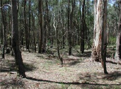 Open forests with deep soils on undulating slopes |  |
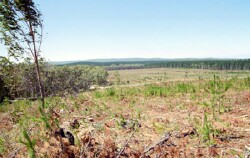
 | 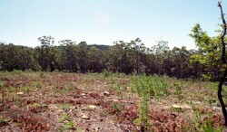 Cleared pine forestry plantation with new seedlings |
Component | 1 | 2 | 3 | 4 |
Proportion of soil-landform unit | 20% | 15% | 60% | 5% |
| CLIMATE Rainfall (mm) | Annual:1000 | |||
| Temperature (oC) | Minimum 6, Maximum 16 | |||
| Precipitation less than potential evapotranspiration | October-March | |||
| GEOLOGY Age and lithology | ||||
| Geomorphology | ||||
| LANDUSE | Uncleared: Nature conservation; water supply; sport and recreation; residential development; softwood plantations Cleared: Softwood plantations; water supply; residiential development; sheet and beef cattle grazing | |||
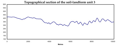
| TOPOGRAPHY Landscape | Rolling hills | |||
| Elevation range (m) | 560-740 | |||
| Local relief (m) | 30 | |||
| Drainage pattern | Dendritic | |||
| Drainage density (km/km2) | 2.2 | |||
| Landform | Hills | |||
| Landform element | Crest and steep slope | Sloep with deep soil | Slope with shallow soil | Drainage line |
| Slope and range (%) | 12 (5-20) | 10 (5-20) | 20 (5-30) | 2 (1-4) |
| Slope shape | Convex | Straight | Straight | Concave |
| NATIVE VEGETATION Ecological Vegetation Class | Herb-rich Foothll Forest/Shrubby Foothill Forest Complex (49.6%); Shrubby Foothill Forest (4.1%); Sedgy Riparian Woodland (3.4%); Herb-rich Foothill Forest (2.0%) | |||
| Dominant species | E. obliqua, E. dives, E. radiata, E. rubida | E. obliqua, E. viminalis, E. radiata, E. rubida, E. cypellocarpa | E. obliqua, E. viminalis, E. radiata, E. rubida, E. dives | E. obliqua, E. viminalis, E. radiata, E. rubida |
| SOIL Parent material | In situ weathered sandstone and shale | In situ weathered sandstone and shale | In situ weathered sandstone and shale | Alluvium, colluvium clay, silt, sand and gravel |
| Description (Corangamite Soil Group) | ||||
| Soil type sites | ||||
| Surface texture | Gravelly loam | Fine sandy loam to clay loam | Fine sandy loam to clay loam | Clay loam |
| Permeability | High | High | Moderate to high | Moderate |
| Depth (m) | 0.5 | 2 | 1 | 2 |
| LAND CHARACTERISTICS, POTENTIAL AND LIMITATIONS | Steep slopes and low permeability leads to overland flow. This flow often creates sheet and rill erosion with major rainfall events. Leaching of salts also occur. | Steep slopes and low permeability leads to overland flow. This flow often creates sheet and rill erosion with major rainfall events. Leaching of salts also occur with nutrient decline. | Steep slopes and low permeability leads to overland flow. This flow often creates sheet and rill erosion with major rainfall events. Leaching of salts also occur with nutrient decline. | Moderate permeability and overland flow are common. Subsurface waterlogging is seasonal.. Gully erosion and leaching of salts also occur. Surface compaction can benefit from controlled traffic. |