Victorian Resources Online (archived)
Soil/Landform Unit 61
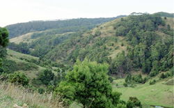 Wild Dog Creek is an example of terrain that is difficult to manage due to prominent steep slopes and landslips of this landscape |
5.75% of CMA region The dissected ranges of the Southern Uplands includes steeply dissected spurs and ridges in the wetter parts of the Otway Range (the largest land system in the study area). Rapid downcutting of streams following uplift of the range has been responsible for forming this rugged landscape, with many slopes more than 60% and cliffs and bluffs in the central area north of Apollo Bay. The soils are young and moderately fertile brown gradational soils. Tall open forests of Eucalyptus regnans reach heights approaching 100 m in the Calder River catchment, but most of the tallest trees have now been milled. E. obliqua and E. cypellocarpa are also common, while E. viminalis occurs in the west and E. globulus is found close to the coast. Pine forests cover large areas of this unit and other parts have been cleared for agriculture. The main hazards to land use are landslips and sheet erosion. Losses in organic matter and soil structure are often apparent following clearing. | 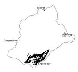 |
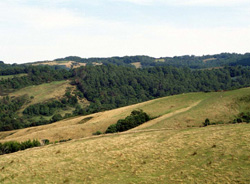 Dissected hills north of Johanna | 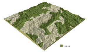 |
 | 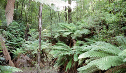 Tree ferns and remnants of tall open forests |
Component | 1 | 2 | 3 |
Proportion of soil-landform unit | 10% | 80% | 10% |
| CLIMATE Rainfall (mm) | Annual: 1100-1750, lowest January (60), highest August (170) | ||
| Temperature (oC) | Annual: 11, lowest July (7), highest February (16) | ||
| Precipitation less than potential evapotranspiration | Temperature: less than 10oC (av.) May-September Precipitation: less than potential evapotranspiration December-February | ||
| GEOLOGY Age and lithology | |||
| Geomorphology | |||
| LANDUSE | Uncleared areas: Hardwood forestry; softwood plantations; nature conservation; water supply; passive recreation Minor cleared areas: Beef cattle grazing and dairy frming on mainly improved pastures; row cropping on gentler slopes | ||
| TOPOGRAPHY Landscape | Deeply dissected hills of the Otway Range | ||
| Elevation range (m) | 90-560 | ||
| Local relief (m) | 165 | ||
| Drainage pattern | Trellis pattern with isolated radial areas | ||
| Drainage density (km/km2) | 3.1 | ||
| Landform | Hills | ||
| Landform element | Crest | Upper and middle slope | Lower slope and drainage line |
| Slope and range (%) | 25 (5-30) | 40 (25-80) | 25 (5-40) |
| Slope shape | Convex | Linear | Concave |
| NATIVE VEGETATION Structure | Tall open forest | Tall open forest | Tall open forest to tall closed forest |
| Dominant species | E. obliqua, E. cypellocarpa, E. regnans, E. ovata, E. globulus, E. viminalis, Acacia melanoxylon | E. regnans, E. cypellocarpa, E. obliqua, E. ovata, E. viminalis, E. globulus | E. regnans, E. obliqua, Acacia melanoxylong, Nothofagus cunninghamii, E. cypellocarpa, E. ovata, E. viminalis, E. globulus |
| SOIL Parent material | In situ weathered sandstone, siltstone and mudstone | In situ weathered sandstone, siltstone and mudstone | Alluvium and colluvium |
| Description (Corangamite Soil Group) | |||
| Soil type sites | OTR416, COF01 | OTR428, OTR736 | |
| Surface texture | Loam | Loam | Loam |
| Permeability | Moderate | Moderate | High |
| Depth (m) | 1.4 | 1.2 | >2 |
| LAND CHARACTERISTICS, POTENTIAL AND LIMITATIONS | High rainfall, moderate permeability and leaching plus loss of organic matter and soil structure upon disturbance lead to nutrient decline and soil compaction, also sheet erosion on steeper slopes. | Clay subsoils on steep slopes subject to periodic saturation are pone to landslips. Steep slopes are prone to sheet and rill erosion. High rainfall, moderate permeability and leaching plus loss of organic matter and soil structure upon disturbance lead to nutrient decline and soil compaction. | Rapid surface runoff from adjacent hills lead to scour gullying, siltation and flooding. High rainfall, high permeability and leaching plus loss of organic matter and soil structure upon disturbance lead to nutrient decline and soil compaction. |