Victorian Resources Online (archived)
Soil/Landform Unit 69
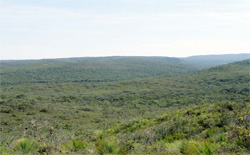 Low open woodland of E. nitida and Xanthorrhoea australis in the understorey typify this landscape, hardpan areas are defined by the absence of tree stratum |
0.67% of CMA region Inland from Anglesea is a deeply dissected landscape with very stunted native vegetation, referred to as the Bald Hills. The Paleogene sediments exposed here include both sands and clays and are characterised by soils of extremely low fertility. Heaths and low woodlands are found on the upper parts of the landscape, where sandy soils are dominant. Xanthorrhoea australis is particularly common and tends to dominate on sites with hardpans developed in the soil profile. Lower down in the landscape, low forests or open forests of Eucalyptus nitida and E. obliqua tend to occur. Productive land uses are limited to the mining of sand and gravel in numerous shallow extraction pits, and mining of coal near Anglesea. Nature conservation and recreation are other forms of land use. | 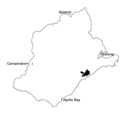 |
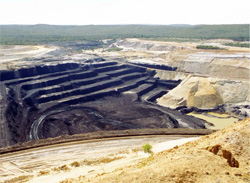 Anglesea coalworks | 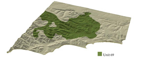 |
 | 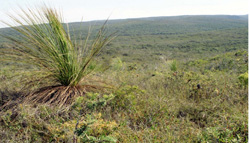 Low open woodland of E. nitida with Xanthorrhoea australis |
Component | 1 | 2 | 3 | 4 | 5 |
Proportion of soil-landform unit | 10% | 25% | 10% | 40% | 15% |
| CLIMATE Rainfall (mm) | Annual: 7000-1000, lowest January (35), highest August (100) | ||||
| Temperature (oC) | Annual: 13, lowest July (8), highest February (18) | ||||
| Seasonal growth limitations | Temperature: less than 10oC (av.) mid June-mid August Precipitation: less than potential evapotranspiration November-March | ||||
| GEOLOGY Age and lithology | Paleogene unconsolidated quartz sand, gravel and clayey silt | ||||
| Geomorphology | |||||
| LANDUSE | Uncleared areas: Nature conservation; extraction of gravel and sand; active and passive recreation; some attempts at pine establishment Minor cleared areas: Mining for coal; some grazing | ||||
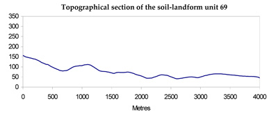
| TOPOGRAPHY Landscape | Deeply dissected hills to the north-west of Anglesea | ||||
| Elevation range (m) | 0-210 | ||||
| Local relief (m) | 90 | ||||
| Drainage pattern | Dendritic | ||||
| Drainage density (km/km2) | 3.0 | ||||
| Landform | Hills | Valley floor | |||
| Landform element | Upper slope and crest | Steep upper slope and crest | Broad, slightly depressed areas of impeded drainage | Lower slope | - |
| Slope and range (%) | 7 (3-15) | 15 (2-35) | 7 (3-12) | 19 (10-35) | 1 (0-3) |
| Slope shape | Convex | Convex | Concave | Linear | Concave |
| NATIVE VEGETATION Structure | Low woodland | Low open woodland | Closed heath | Open forest | Closed scrub |
| Dominant species | E. nitida | E. nitida | Xanthorrhoea australis, Casuarina Pusilla, Platylogium obtusangulum, Leptospermum myrrsinoides | E. obliqua, E. nitida | E. ovata, L. juniperinum, L. lanigerum, Acacia verticillata |
| SOIL Parent material | Kaolinitic silty clay, surface layers of quyartz sand | Quartz sand and gravel | Quartz sand and gravel | Sand, silt and clay | Plant remains; alluvial silt, sand and gravel |
| Description (Corangamite Soil Group) | |||||
| Soil type sites | OTR500 | OTR742, OTR426 | OTR497, OTR742, CLRA13 | OTR733, CLRA13 | |
| Surface texture | Sandy loam | Loamy sand | Loamy sand | Loamy sand | Silty loam |
| Permeability | Low | Very high | Low | High | Very low |
| Depth (m) | >2 | >2 | 0.6 | >2 | >2 |
| LAND CHARACTERISTICS, POTENTIAL AND LIMITATIONS | Weakly structured surface soils and slowly permeabile subsoils on moderate slopes are prone to sheet and rill erosion. Clay subsoils subject to periodic saturation are prone to landslips. | Very low inherent fertility and high permeability lead to nutrient decline. Steeper slopes with compacted soils are prone to sheet, rill and gully erosion (scouring). | Very low inherent fertility with some leading of permeable surface soils leads to nutrient decline. Impermeable hardpans prevent vertical drainage leading to seasonal waterlogging. | Low inherent fertility and high permeability lead to nutrient decline. Steeper slopes with weak structured surface soils are prone to sheet erosion. | High seasonal watertable leads to waterlogging and soil compaction. Rapid runoff from adjacent hills leads to flooding, siltation and gully erosion. |