Victorian Resources Online (archived)
Soil/Landform Unit 75
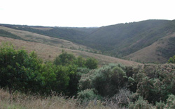 Steeply dissected coastal plain with blue gum plantations near Johanna |
0.20% of CMA region In the vicinity of Cape Otway, outcrops of Paleogene clay, silt, sand, limestone and marl all exist. Three separate areas - Johanna, Hordern Vale, and inland from Point Franklin and Blanket Bay. All areas are generally similar, but possess distinct differences in specific features. The limestone and marl outcrops are confined to marine terraces at Hordern Vale. The Johanna area is distinguished by its dominance of red sands. The area east of Cape Otway includes hilltops of kaolinitic clay and silt and these carry rare low woodlands of Eucalyptus kitsoniona. In general, these landscapes are old with areas of ferruginised soils on the highest parts. Recent dissection has often been superimposed on the more undulating areas, resulting in straight slopes with youthful soil profiles. Land uses are very diverse. Areas that have been cleared are used for dairy farming, grazing of sheep and beef cattle, a small amount of potato growing and more recently blue gum plantations. Those areas that remain uncleared are selectively logged, and also have nature conservation values. Sheet erosion and landslips have been quite severe on some of the steeper areas, and some gully erosion occurs on the slopes coming away from the ferruginised areas. |  |
 Valley floor with steep lower colluvial slopes | 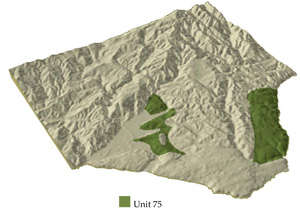 |
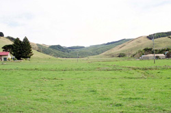
 | 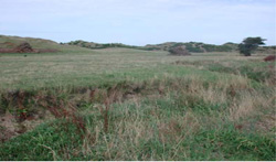 Floodplain of the valley floor near Johanna |
Component | 1 | 2 | 3 | 4 | 5 | 6 | 7 |
Proportion of soil-landform unit | 20% | 8% | 7% | 4% | 25% | 30% | 6% |
| CLIMATE Rainfall (mm) | Annual: 900-1250, lowest January (50), highest July (130) | ||||||
| Temperature (oC) | Annual: 13, lowest July (9), highest February (17) | ||||||
| Seasonal growth limitations | Temperature: less than 10oC (av.) July Precipitation: less than potential evapotranspiration late November-February | ||||||
| GEOLOGY Age and lithology | Paleogene marine carbonaceous clay to sand; Cretaceous fluvio-volcanic sediments; Neogene marine marl. | ||||||
| Geomorphology | |||||||
| LANDUSE | Cleared areas: Beef cattle grazing; dairy frming; sheet grazing; row crops Uncleared areas: Hardwood forestry for sawlogs and pulpwood; sand extraction; nature conservation; passive recreation | ||||||
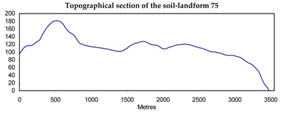
| TOPOGRAPHY Landscape | Undulating coastal plain surrounding Cape Otway | ||||||
| Elevation range (m) | 0-200 | ||||||
| Local relief (m) | 60 | ||||||
| Drainage pattern | Dendritic | ||||||
| Drainage density (km/km2) | 2.2 | ||||||
| Landform | Rises | Valley floors | Rises | ||||
| Landform element | Upper slope and crest | Slope and river terrace | Swale | Marine terrace | Steeper slope | Upper slope and crest | Rise |
| Slope and range (%) | 5 (1-15) | 7 (1-15) | 0 (0-1) | 25 (10-55) | 30 (3-45) | 8 (2-20) | 3 (0-7) |
| Slope shape | Convex | Linear | Concave | Convex | Linear | Linear | Irregular |
| NATIVE VEGETATION Structure | Open forest | Open forest | Closed scrub | Woodland | Open forest | Tall open forest | Low woodland |
| Dominant species | E. obliqua, E. baxteri, E. cypellocarpa, E. aromaphloia, E. viminalis | E. obliqua, E. baxteri, E. viminalis, E. ovata | Leptospermum lanigerum | E. obliqua, E. viminalis | E. obliqua, E. cypellocarpa. E. baxteri | E. cypellocarpa, E. obliqua, E. viminalis, E. globulus | E. kitsoniana, Melaleuca squarrosa, Melaleuca ericifolia |
| SOIL Parent material | Ferruginsed sediments | Clay, silt and sand | Alluvial clay, silt and sand | Freshely weathered limestone and marl | Quartz sand | Clay, silt and sand | Kaolinitic clay, silt and sand |
| Description (Corangamite Soil Group) | |||||||
| Soil type sites | OTR782 | OTR750 | OTR722 | - | - | ||
| Surface texture | Gravelly sand | Fine sandy loam | Sandy loam | Fine sandy clay loam | Loamy sand | Fine sandy loam | Silty loam |
| Permeability | Moderate | Low | Very low | Low | Very high | High | Very low |
| Depth (m) | >2 | >2 | >2 | 0.5 | >2 | >2 | >2 |
| LAND CHARACTERISTICS, POTENTIAL AND LIMITATIONS | Low inherent fertility and phosphorus fixation lead to nutrient decline. | Dispersible subsoils are prone to gully erosion. | Clay subsoils on steep slopes subject to periodic saturation are prone to landslips. | Steep slopes with weakly structured soils are prone to some sheet erosion. High rainfall and high permeability lead to nutrient decline. | High rainfall, high permeability and leaching lead to nutrient decline and surface compaction upon disturbance. | Low permeability and high annual rainfall lead to waterlogging and soil compaction. | |