Victorian Resources Online (archived)
Site SW21
| Location: Simpson | Australian Soil Classification: Humose-Acidic, Dystrophic, Grey DERMOSOL |
| General Landscape Description: Grazing paddock (dairy). | Geology: Tertiary - Moorabool Viaduct Formation. |
| Mapping Unit: Simpson Land System (Pitt, 1981). | Site Description: Gently undulating plain 'grass-tree country'. |
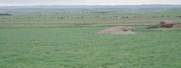 Site SW21 Landscape |
Soil Profile Morphology:
Surface Soil
| A1 | 0-20 cm | Black (10YR2/1); fine sandy loam; weak coarse blocky, parting to medium blocky structure; weak to firm consistence moist; pH 4.9; clear change to: | 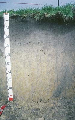 Site SW21 profile photo. |
| A2 | 20-40 cm | Dark greyish brown (10YR4/2); light fine sandy clay loam; weak to moderate medium polyhedral structure; firm consistence moist; very few (<1%) ferromanganiferous nodules (5 mm size); some rusty root channel mottling present; pH 4.8; clear change to: | |
| Subsoil | |||
| B1 | 40-60 cm | Dark greyish brown (10YR4/2) with yellowish brown (10YR5/8) and light yellowish brown (10YR6/4) mottles; fine sandy clay loam; weakly structured; very firm consistence moist; pH 4.8; gradual change to: | |
| B21 | 60-90 cm | Light brownish grey (10YR6/2) with yellowish brown (10YR5/8) mottles; light clay; weak to moderate coarse blocky, parting to medium blocky structure; firm consistence moist; pH 4.7; gradual change to: | |
| B22 | 90+ cm | Light brownish grey (10YR6/2) with yellowish brown (10YR5/8) mottles; light medium clay; weak to moderate coarse blocky, parting to medium blocky structure; very few (1%) iron nodules (5-10 mm size) and quartz fragments (2-3 mm size); pH 4.6. | |
Key Profile Characteristics:
pH | Salinity Rating | |||
Surface (A1 horizon) | Very Strongly Acid | Low | Non-Sodic | None |
Subsoil (B21 horizon) | Very Strongly Acid | Very Low | Non-Sodic | None |
Deeper subsoil (at 90+ cm) | Very Strongly Acid | Very Low | Non-Sodic | None |
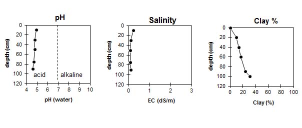 |
Horizon | Horizon Depth (cm) | pH (water) | pH CaCl2 | EC 1:5 | Exchangeable Cations | |||
Ca | Mg | K | Na | |||||
meq/100g | ||||||||
A1 | 0-20 | 4.9 | 4.3 | 0.22 | 6.2 | 0.7 | 0.4 | 0.1 |
A2 | 20-40 | 4.8 | 4.1 | 0.1 | 0.7 | 0.5 | 0.05 | 0.05 |
B1 | 40-60 | 4.8 | 4.2 | 0.08 | 0.4 | 0.3 | 0.05 | 0.05 |
B21 | 60-90 | 4.7 | 4.1 | 0.08 | 0.3 | 0.4 | 0.05 | 0.05 |
B22 | 90+ | 4.6 | 4 | 0.1 | 0.3 | 0.6 | 0.05 | 0.05 |
Horizon | Horizon Depth (cm) | Field Capacity pF2.5 | Wilting Point pF4.2 | Coarse Sand (0.2-2.0 mm) | Fine Sand (0.02-0.2 mm) | Silt (0.002-0.02 mm) | Clay (<0.002 mm) |
A1 | 0-20 | 31 | 20 | 26 | 36 | 11 | 10 |
A2 | 20-40 | 19 | 8 | 25 | 40 | 15 | 14 |
B1 | 40-60 | 18 | 7 | 26 | 40 | 14 | 17 |
B21 | 60-90 | 20 | 8 | 24 | 39 | 10 | 24 |
B22 | 90+ | 22 | 11 | 21 | 34 | 15 | 31 |
Profile Described By: Mark Imhof and Austin Brown, August 1998.