Victorian Resources Online (archived)
Site SW23
| Location: Simpson | Australian Soil Classification: Acidic, Mesotrophic, Brown DERMOSOL |
| General Landscape Description: Grazing paddock (dairy). | Mapping Unit: Tomahawk Creek Land System (Pitt, 1981). |
| Site Description: Creek Terrace. | Geology: Tertiary - Moorabool Viaduct Formation. |
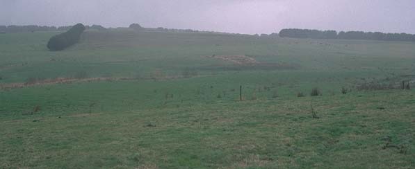 Site SW23 landscape |
Soil Profile Morphology:
Surface Soil
| A1 | 0-10 cm | Dark brown (10YR3/3); fine sandy clay loam; weak consistence moist; pH 5.6; abrupt change to: | 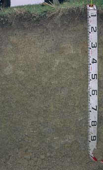 Site SW23 profile photo. |
| A2 | 10-25 cm | Light brownish grey (10YR6/2); silty clay loam; weak coarse blocky structure; rusty root channel mottling present; pH 5.4; clear change to: | |
| Subsoil | |||
| B1 | 25-40 cm | Light yellowish brown (2.5Y6/4) with reddish yellow (7.5YR6/6) mottles; heavy silty clay loam; weak to moderate coarse blocky structure; pH 5.2; clear change to: | |
| B21 | 40-70 cm | Brown (10YR5/3) with reddish yellow (7.5YR6/6) mottles; silty clay; moderate coarse blocky, parting to strong medium polyhedral structure; pH 5.0; clear change to: | |
| B22 | 70+ cm | Light brownish grey (10YR6/2) with brownish yellow (10YR6/6); light medium clay; weak very coarse prismatic, parting to strong coarse blocky and strong fine to medium polyhedral structure; pH 5.0. | |
Key Profile Features:
- Gradual increase in texture (clay percentage) down the soil profile.
Key Profile Characteristics:
pH | Salinity Rating | |||
Surface (A1 horizon) | Moderately Acid | Very low | Non-sodic | none |
Subsoil (B21 horizon) | Strongly Acid | Very low | Non-sodic | none |
Deeper subsoil (at 70+ cm) | Strongly Acid | Very low | Non-sodic | none |
 |
Horizon | Horizon Depth (cm) | pH (water) | pH CaCl2 | EC 1:5 | Exchangeable Cations | |||
Ca | Mg | K | Na | |||||
meq/100g | ||||||||
A1 | 0-10 | 5.6 | 4.9 | 0.15 | 5.4 | 1.1 | 0.2 | 0.1 |
A2 | 10-25 | 5.4 | 4.6 | 0.1 | 1.9 | 0.8 | 0.3 | 0.05 |
B1 | 25-40 | 5.2 | 4.3 | 0.11 | 1.7 | 1.3 | 0.3 | 0.1 |
B21 | 40-70 | 5 | 4.2 | 0.13 | 1.8 | 1.8 | 0.3 | 0.2 |
B22 | 70+ | 5 | 4.2 | 0.15 | 2.2 | 3.9 | 0.3 | 0.3 |
Horizon | Horizon Depth (cm) | Field Capacity pF2.5 | Wilting Point pF4.2 | Coarse Sand (0.2-2.0 mm) | Fine Sand (0.02-0.2 mm) | Silt (0.002-0.02 mm) | Clay (<0.002 mm) |
A1 | 0-10 | 36 | 13 | 5 | 43 | 25 | 16 |
A2 | 10-25 | 26 | 8 | 2 | 50 | 30 | 16 |
B1 | 25-40 | 27 | 11 | 2 | 47 | 26 | 25 |
B21 | 40-70 | 29 | 13 | 2 | 42 | 26 | 30 |
B22 | 70+ | 31 | 17 | 1 | 35 | 21 | 42 |
Profile described by: Mark Imhof and Austin Brown, August 1998.