Victorian Resources Online (archived)
Site SW25
| Location: Camperdown | Australian Soil Classification: Ferric (& Sodic), Eutrophic, Brown CHROMOSOL |
| General Landscape Description: Grazing paddock (dairy). | Mapping Unit: Unit 2 (Maher and Martin, 1987). |
| Site Description: Gently undulating plain. | Geology: Quaternary - Newer volcanics (scoria). |
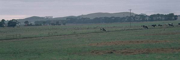 Site SW25 landscape |
Soil Profile Morphology:
Surface Soil
| A11 | 0-10 cm | Very dark brown (10YR2/2); very fine sandy clay loam; weak coarse blocky, parting to moderate medium polyhedral structure; very firm consistence dry; pH 5.3; gradual change to: | 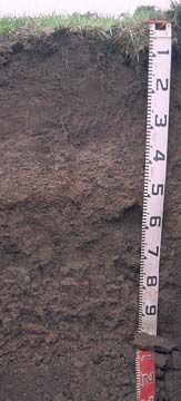 Site SW25 profile photo. |
| A12 | 10-30 cm | Very dark greyish brown (10YR3/2); very fine sandy clay loam; moderate medium polyhedral, parting to moderate to strong fine polyhedral structure; pH 5.3; firm consistence moist; clear change to: | |
| A2 | 30-50 cm | Dark brown (10YR4/3); conspicuously bleached; gravelly clay loam; contains many (50%) ferruginous nodules (2-10 mm size); pH 6.2; abrupt change to: | |
| Subsoil | |||
| B21 | 50-60 cm | Dark brown (7.5YR4/4); medium clay; moderate coarse polyhedral, parting to strong medium polyhedral structure; strong consistence dry; pH 6.7: | |
| B22 | 60-80 cm | Dark brown (10YR4/3); medium heavy clay; strong coarse prismatic, parting to medium prismatic and moderate coarse blocky structure; strong consistence dry; pH 7.0: | |
| B23 | 80+ cm | Dark brown (7.5YR4/2) with yellowish brown (10YR5/8) mottles; medium clay; strong coarse prismatic, parting to medium prismatic and moderate coarse to medium blocky structure; pH 7.2. | |
Key Profile Features:
- Many ferruginous nodules in subsurface (A2).
- Strong texture contrast between surface (A) horizons & subsoil (B21) horizon.
Key Profile Characteristics:
pH | Salinity Rating | ||
Surface (A1 horizon) | Strongly Acid | Very Low | Non-Sodic |
Subsoil (B21 horizon) | Slightly Acid | Very Low | Non-Sodic |
Deeper subsoil (at 80+ cm) | Slightly Alkaline | Very Low | Sodic |
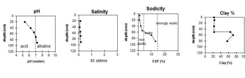 |
Horizon | Horizon Depth (cm) | pH (water) | pH CaCl2 | EC 1:5 | NaCl % | Exchangeable Cations | |||
Ca | Mg | K | Na | ||||||
meq/100g | |||||||||
A11 | 0-10 | 5.3 | 4.7 | 0.31 | 0.02 | 7.9 | 1.6 | 1.2 | 0.1 |
A12 | 10-30 | 5.3 | 4.6 | 0.11 | 6.7 | 2 | 0.4 | 0.1 | |
A2 | 30-50 | 6.2 | 5.3 | 0.07 | 5.1 | 2.6 | 0.3 | 0.2 | |
B21 | 50-60 | 6.7 | 5.8 | 0.11 | 6.2 | 8.4 | 0.2 | 0.8 | |
B22 | 60-80 | 7 | 6.1 | 0.14 | 5.9 | 11 | 0.3 | 2 | |
B23 | 80+ | 7.2 | 6.2 | 0.16 | 6.6 | 15 | 0.3 | 3.2 | |
Horizon | Horizon Depth (cm) | Field Capacity pF2.5 | Wilting Point pF4.2 | Coarse Sand (0.2-2.0 mm) | Fine Sand (0.02-0.2 mm) | Silt (0.002-0.02 mm) | Clay (<0.002 mm) |
A11 | 0-10 | 39 | 16 | 9 | 34 | 21 | 22 |
A12 | 10-30 | 34 | 12 | 9 | 37 | 23 | 23 |
A2 | 30-50 | 28 | 11 | 23 | 34 | 17 | 22 |
B21 | 50-60 | 44 | 28 | 6 | 16 | 8 | 64 |
B22 | 60-80 | 51 | 32 | 3 | 12 | 11 | 71 |
B23 | 80+ | 53 | 31 | 5 | 20 | 16 | 56 |
Profile described by: Mark Imhof and Austin Brown, August 1998.